- Masoala National Park
-
Masoala National Park IUCN Category II (National Park)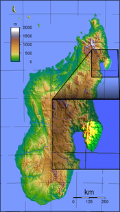
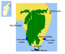
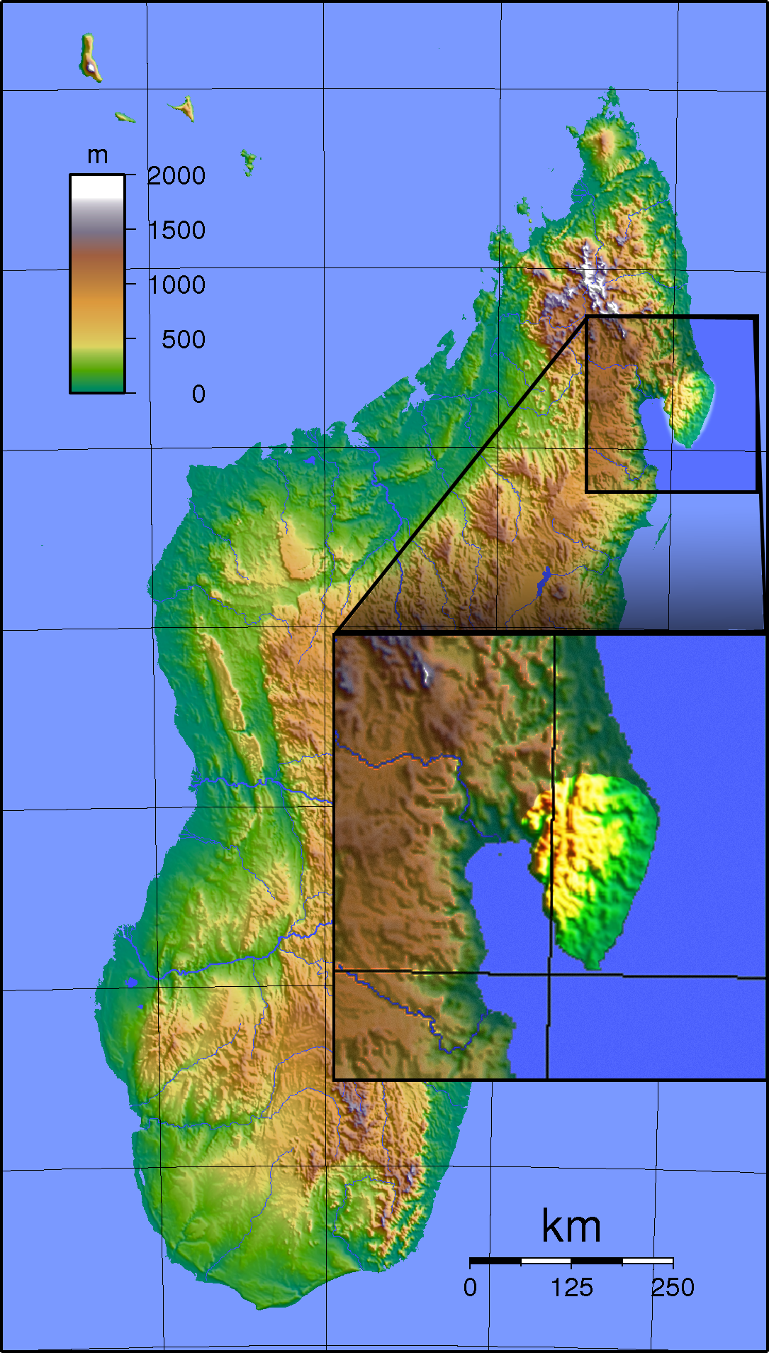
Location of Masoala National ParkLocation North-east Madagascar Nearest city Maroantsetra and Antalaha Coordinates 15°18′01″S 50°03′09″E / 15.30028°S 50.0525°ECoordinates: 15°18′01″S 50°03′09″E / 15.30028°S 50.0525°E Area 2,400 km² Established 1997 Visitors 3000 (in 2005) Governing body Madagascar National Parks Association Masoala National Park, in northeast Madagascar, is the largest of the island's protected areas. Most of the park is situated in Sava Region and a part in Analanjirofo. Created in 1997, the park protects 2,300 square kilometres of rainforest and 100 square kilometres of marine parks. The Masoala peninsula is exceptionally diverse due to its huge size, and variety of habitats. Altogether, the park protects rainforest, coastal forest, flooded forest, marsh, and mangrove. Three marine parks protect coral reefs and a dazzling array of marine life.
 The forested coast of Masoala National Park
Masoala provides an excellent opportunity to experience the unique flora and fauna of the big island. There are ten lemur species, including the flamboyant Red Ruffed Lemur, which is native to the peninsula. The island reserve of Nosy Mangabe is one of the best sites in Madagascar to try and glimpse the elusive nocturnal Aye-aye.
Masoala harbors many other novelties, such as the Madagascar day gecko, Leaf-tailed gecko, chameleons of all sizes, spectacular birds such as the Helmet Vanga, and rare species such as the Red Owl and Tomato frog. Masoala is also home to the spectacular day-flying sunset moth, Chrysiridia rhipheus. The Madagascar Serpent-eagle was recently rediscovered here, and exists in healthy populations only in this part of north east Madagascar.
Three marine parks are included in the Masoala National Park: Tampolo in the West, Ambodilaitry in the South, and Ifaho in the East. These are among the most interesting marine environments in Madagascar and are superb destinations for kayaking and snorkeling.
Each year from July to early September, hundreds of Humpback Whales visit the Antongil Bay during their long migration. The warm protected waters of the bay provide an ideal breeding and calving ground for these magnificent marine mammals.
 A leaf-tailed gecko, Uroplatus fimbriatus, one of Madagscar's extraordinary endemic reptiles
The park can be accessed from the towns of Maroantsetra or Antalaha. From Maroantsetra, transport by motor boat can be arranged. From Antalaha, the park can be accessed by road to Cap Est using daily bush taxis or by mountain bike as far as the village of Masoala. The park is accessible from several lodges on the peninsula, and there are six park-maintained campsites. Camping materials can be hired in Maroantsetra. The main trails for visitors are at Nosy Mangabe, Tampolo/Ambodiforaha, Cap Est, and a several-day hike is possible across the peninsula. Campsites are maintained at Nosy Mangabe, Cap Est, Ambatolaidama, and each of the three marine parks. Many villages on the peninsula also provide inexpensive bungalows or basic guest rooms. Antalaha and Maroantsetra both offer a wide array of accommodations, as well as guides and porters for travel on the peninsula. All visits to the park must be accompanied by an official park-approved guide. Detailed information on arranging trips is available from the National Park or guide offices in Maroantsetra and Antalaha.
 Masoala National Park
This is an exceptionally wet area of Madagascar. The driest part of the year is from September to December. As the park is accessible only by a three-hour boat journey, the cyclone season (January to March) is best avoided.
In June 2007, Masoala was designated as a World Heritage Site as part of a cluster of parks that represent the biodiversity of the eastern rainforests of the country. The other national parks included are Marojejy, Zahamena, Ranomafana, Andringitra, and Andohahela.[1]
During 2009 and 2010, the national park has invaded by thousands of illegal loggers searching for rosewood.
See also
- Antongil Bay
- National parks of Madagascar
- Illegal logging in Madagascar
References
External links
- Masoala National Park official site
- Trouble in Lemur Land- a professional 50 minute HD film about illegal rosewood logging in Madagascar and the impact on the silky sifaka lemur
- Human Rights Issues, see www.humanrightsmasoala.org
National Parks and Reserves of Madagascar Strict Nature Reserves 
National parks Montagne d'Ambre · Andohahela · Andringitra · Ankarafantsika · Baie de Baly · Bemaraha · Isalo · Kirindy Mitea · Mantadia · Marojejy · Masoala · Midongy du sud · Ranomafana · Tsimanampetsotsa · Zahamena · Zombitse-VohibasiaWildlife Reserves Analamazoatra · Analamerana · Andranomena · Ambatovaky · Forêt d'Ambre · Ambohijanahary · Ambohitantely · Anjanaharibe-Sud · Ankarana · Bemarivo · Beza Mahafaly · Bora · Kalambatritra · Kasijy · Manombo · Mangerivola · Maningoza · Manongarivo · Marotandrano · Nosy Mangabe · Pic d'Ivohibe · Tampoketsa AnalamaitsoCategories:- IUCN Category II
- National parks and reserves of Madagascar
- Sava Region
- Analanjirofo
- Protected areas established in 1997


Wikimedia Foundation. 2010.