- O'Leary, Prince Edward Island
-
Village of O’Leary — Village — 
SealLocation of O'Leary in Prince Edward Island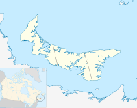

Coordinates: 46°42′25″N 64°13′50″W / 46.70694°N 64.23056°W Country Canada Province Prince Edward Island County Prince County Parish Halifax Government - Type Community Council - Chairperson Nancy Wallace - Vice-Chair Dana Harris - Administrator Beverley Shaw - Councilors Judy Milligan
Linda Stetson
Frances Dewar
Sean O'Halloran
Eric GavinArea - Total 4.1 km2 (1.57 sq mi) Elevation 31 m (102 ft) Population - Total 861 - Density 547.2/km2 (1,417.2/sq mi) Canadian Postal code C0B Area code(s) 902 Telephone Exchange 859 NTS Map 021I09 GNBC Code BABYS Website http://www.community.oleary.pe.ca/ O'Leary (2001 population: 860) is a Canadian village in Prince County, Prince Edward Island.
The community's economy is tied to the potato farming industry and is home to the Prince Edward Island Potato Museum.
Climate
Climate data for O'Leary Month Jan Feb Mar Apr May Jun Jul Aug Sep Oct Nov Dec Year Record high °C (°F) 13.5
(56.3)13
(55)16.5
(61.7)21.5
(70.7)32.2
(90.0)33.5
(92.3)32.8
(91.0)32.5
(90.5)32.5
(90.5)24
(75)20
(68)13.9
(57.0)33.5
(92.3)Average high °C (°F) −4.4
(24.1)−3.8
(25.2)0.7
(33.3)6.5
(43.7)14.3
(57.7)19.8
(67.6)23.2
(73.8)22.8
(73.0)18
(64)11.4
(52.5)5.1
(41.2)−1.2
(29.8)9.4 Average low °C (°F) −12.7
(9.1)−12.2
(10.0)−7
(19)−1.2
(29.8)4.3
(39.7)9.8
(49.6)13.8
(56.8)13.6
(56.5)9.5
(49.1)4.1
(39.4)−0.9
(30.4)−7.9
(17.8)1.1 Record low °C (°F) −31
(−24)−29.4
(−20.9)−25.6
(−14.1)−13.9
(7.0)−6.1
(21.0)−1.1
(30.0)3.9
(39.0)3.3
(37.9)−1.1
(30.0)−6.7
(19.9)−15
(5)−27.2
(−17.0)−31
(−24)Precipitation mm (inches) 97.1
(3.823)78.3
(3.083)89.4
(3.52)85.2
(3.354)95.6
(3.764)82.6
(3.252)100.1
(3.941)84.9
(3.343)99.7
(3.925)107.9
(4.248)110.2
(4.339)109.7
(4.319)1,140.7
(44.909)Source: Environment Canada[1] References
- ^ Environment Canada Canadian Climate Normals 1971–2000, accessed 15 July 2009
Coordinates: 46°42′25″N 64°13′50″W / 46.70694°N 64.23056°W
 Subdivisions of Prince Edward Island
Subdivisions Cities Towns  Category:Prince Edward Island ·
  Portal:Prince Edward Island ·
  WikiProject:Prince Edward IslandCategories:
- Communities in Prince County, Prince Edward Island
- Prince Edward Island geography stubs

Wikimedia Foundation. 2010.