- Ninewells
-
Coordinates: 56°27′47″N 3°02′19″W / 56.463190°N 3.038596°W
Ninewells
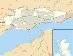
 Ninewells shown within the City of Dundee
OS grid reference NO361306 Council area City of Dundee Lieutenancy area Dundee Country Scotland Sovereign state United Kingdom Post town DUNDEE Postcode district DD2 Dialling code 01382 Police Tayside Fire Tayside Ambulance Scottish EU Parliament Scotland UK Parliament Dundee West Scottish Parliament Dundee West
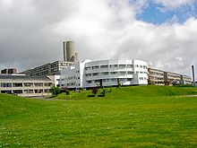
North East ScotlandList of places: UK • Scotland • Ninewells is an area of Dundee, Scotland, known for its hospital.
Transport
Many bus routes in Dundee terminate or call at Ninewells Hospital. Ninewells was the western terminus for Dundee trams prior to their removal.
History
Ninewells Hospital is built on what was Menzieshill and Gowriehill farms. The village of Ninewells was on the South side of the Perth Road.
At one time Ninewells had a shop,blacksmiths,nursery and a garage. It also had a tram terminus. Only the garage still remains.
Areas of Dundee (category) Ardler · Balgay · Balgillo · Balgowan · Barnhill · Beechwood · Blackness · Broughty Ferry · Camperdown · Charleston · City Centre · Claverhouse · Craigiebank · Douglas · Downfield · Fairmuir · Fintry · Gowrie Park · Hilltown · Kirkton · Law · Linlathen · Lochee · Logie · Menzieshill · Mid Craigie · Mill o' Mains · Ninewells · Pitkerro · St Marys · Stobswell · West End · Woodside · WhitfieldSee also: List of places in DundeeCategories:- Areas of Dundee
- Tayside geography stubs
Wikimedia Foundation. 2010.


