- Alabama State Route 267
Infobox road
state=AL
type=AL
route=267
alternate_name=Shug Jordan Parkway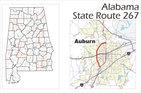
length_mi=5.1
length_ref=Distances computed with Google Maps' direction features on2008-04-15 .]
length_round=1
established=1986 [http://colepages.com/routes251275.html#ala267 Highway Route Info Routes 251 - 275] ]
direction_a=South
direction_b=North
starting_terminus=
junction= at Auburn
ending_terminus= at Auburn
previous_route=265
next_route=269State Route 267 is a
state highway inAlabama and a loop route of State Route 147, bypassing downtown Auburn to the west. For its entire 5.1 mile (8.2 km) length, SR-267 is known as the Shug Jordan Parkway (named forAuburn University football coach Ralph "Shug" Jordan).Route description
With the exception of a 900-yard segment at the northern terminus, State Route 267 lies wholly within the city limits of
Auburn, Alabama . The highway makes up the western half of Auburn's cicumfrential inner loop, University Drive.State Route 267 begins at State Route 147 (South College Street) at the southernmost point of the
Auburn University campus. From there, it heads north-northwest and travels through the college's agricultural research fields for the next two miles. At milepost 2.3, SR-267 has ajughandle interchange with SR-14. SR-267 then turns to the northeast for the next 2.8 miles before terminating back at SR-147 (now North College Street).History
The original designation of SR-267 was
U.S. Route 29 . In 1986, the 5.1 mile segment in Auburn was reassigned as the present-day SR-267. [http://colepages.com/usroutes.html#us29 U.S. Highway Routes] ]The initial planning for State Route 267 began in the mid-1950s, when the City of Auburn first began planning for a perimeter road. While the eastern half of this perimeter road (named University Drive in the early 1960s) would follow segments of existing roads, the western half would be completely new. In addition, the western segment would cut across the property of
Auburn University , a state institution over which the city had no power ofeminent domain to acquire right-of-way. As such, this western segment was turned over to the Alabama Department of Transportation for construction and maintenance.Initial right-of-way acquisition began in 1966, with construction beginning the following year. The original design called for a four-lane limited-access
expressway , with interchanges at State Route 14 and Wire Road; however, budget constraints eliminated all grade separations except for the one at SR 14. The highway was completed in 1971 as "West University Drive", and was soon renamed "Shug Jordan Parkway" for the famed Auburn University football coachRalph Jordan .Major intersections
jctint|state=AL
county=Lee
cspan=3
location=Auburn
lspan=3
mile=0.0
road=
notes=Southern terminusjctint|state=AL
mile=2.2
road=
notes=jctint|state=AL
mile=5.1
road= SR-14
notes=Northern terminusReferences
Wikimedia Foundation. 2010.