- Alabama State Route 147
Infobox road
state=AL
type=AL
route=147
length_mi=
length_round=
length_ref=
established=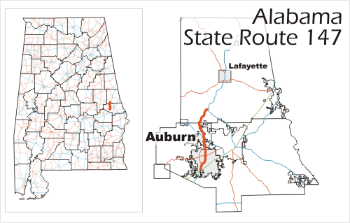
direction_a=South
starting_terminus=
junction=
direction_b=North
ending_terminus=
counties=Lee County, Chambers County
previous_type=AL
previous_route=146
next_type=AL
next_route=148State Route 147 is a public
highway maintained by the state ofAlabama in east central Alabama. The highway acts as a connector between U.S. Highway 29 and Interstate 85 in the southern part ofAuburn, Alabama , U.S. Highway 280 in northern Auburn, and U.S. Highway 431 between Auburn andLafayette, Alabama .State Route 267 is a bypass of SR-147.
Route description
SR-147 lies mostly within the city limits of
Auburn, Alabama . Approximately one mile of the road runs through unincorporated Lee County, while 4.2 miles lies in rural Chambers County.* SR-147 is routed along College Street in Auburn from its beginning through mile 8.6.
* SR-147 shares a route with State Route 14 for one block in downtown Auburn.
* SR-147 is routed along Birmingham Highway in Auburn from mile 8.6 to mile 9.0.
* SR-147 shares a route with U.S. Highway 280 (State Route 38) from mile 8.6 to mile 9.0.
* SR-147 is routed along Heath Road in northern Auburn.History
In 1939, the state of Alabama constructed the original segment of SR-147, connecting U.S. Highway 29 in downtown Auburn to what was then U.S. Highway 241 (now US-280) at The Bottle. In 1947, SR-147 was extended north three miles to Gold Hill. The final extension from Gold Hill to U.S. Highway 431 to complete the northern portion of the highway did not occur until 1960. In 1998, the relocation of U.S. Highway 29 to the Interstate 85 freeway led to the movement of the southern terminus of the highway from the intersection of Mitchum Avenue and College Street in downtown Auburn to a point four miles south at the College Street interchange with Interstate 85.
Future
In 2006, the Alabama Department of Transportation began a relocation study for the southern half of SR-147. The study is to look at the possibility of rerouting the highway some four miles west of Auburn, along the route of the proposed Auburn Outer Loop. The proposed relocation would begin at Interstate 85 at the under-development Cox Road interchange (Exit 50) and would travel north thirteen miles to connect with US-280 at mile marker 101.4, where it would join the current northern section of SR-147.
Major intersections
Alabama 147 intersects with the following highways:
* Interstate 85 at Exit 51 in southern Auburn (mile 0.0).
* U.S. Highway 29 (State Route 15) in southern Auburn (mile 0.0).
* State Route 267 in southern Auburn (mile 1.4).
* State Route 14 in downtown Auburn (mile 3.9-4.0)
* State Route 267 in northern Auburn (mile 5.8)
* U.S. Highway 280 (State Route 38) in northern Auburn (mile 8.6-9.0)
* U.S. Highway 431 (State Route 1), ten miles south of Lafayette (mile 16.9).
Wikimedia Foundation. 2010.