- Øverbygd
-
Øverbygd herred — Former Municipality — Øvre Dividal park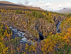
Coordinates: 69°01′27″N 19°17′45″E / 69.02417°N 19.29583°ECoordinates: 69°01′27″N 19°17′45″E / 69.02417°N 19.29583°E Country Norway County Troms District Nord-Norge Municipality ID NO-1923 Adm. Center Skjold Area[1] – Total 2,132 km2 (823.2 sq mi) Created from Målselv in 1925 Merged into Målselv in 1964 Øverbygd is a former municipality in Troms county in Norway. It is located in the present-day municipality of Målselv from the Lille Rostavatn lake along the Målselva river through the Målselvdalen valley. The village of Skjold is home to a large garrison for the Norwegian Army. The Øvre Dividal National Park is also located here.
Contents
History
 ØverbygdØverbygd, Norway
The municipality of Øverbygd was established on 1 July 1925 when it was separated from the municipality of Målselv. It had an initial population of 566 inhabitants. On 1 January 1964, Øverbygd was merged back into a newly enlarged Målselv municipality. Prior to the merger, Øverbygd had a population of 1,232.[1][2]
World War II
During World War II, the German army created a military base at Øverbygd. The base was initially a supply point for the German forces attack on Murmansk. German soldiers on retreat at the end of the war came through Øverbygd. Maukstadmoen and Holmen were undeveloped pine forests,but virtually all of the commercial forest was cut down to provide German troops land and building materials.
Large barracks for the officer's quarters were established on Maukstadmoen. They also built large stock barracks, a cold storage plant, and a German military hospital. A Prisoner-of-war camp for Russian prisoners of war and medical camp was built near Holmen.
References
- ^ a b "Øverbygd – kommune" (in Norwegian). Store norske leksikon. http://www.snl.no/%C3%98verbygd/kommune. Retrieved 2010-01-21.
- ^ Jukvam, Dag (1999) (in Norwegian) (PDF). Historisk oversikt over endringer i kommune- og fylkesinndelingen. Statistisk sentralbyrå. http://www.ssb.no/emner/00/90/rapp_9913/rapp_9913.pdf.
External links
Categories:- Former municipalities of Norway
- Målselv
- Populated places of Arctic Norway


Wikimedia Foundation. 2010.