- Northern Liberties Township, Pennsylvania
-
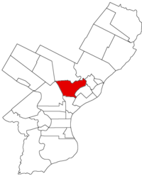 Map of Philadelphia County, Pennsylvania highlighting Northern Liberties Township prior to the Act of Consolidation, 1854
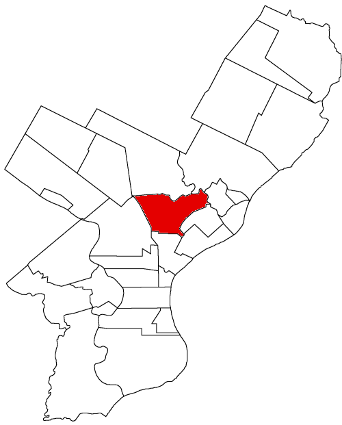
Northern Liberties Township is a defunct township that was located in Philadelphia County, Pennsylvania. The township ceased to exist and was incorporated into the City of Philadelphia after the passage of the Act of Consolidation, 1854.
History
The Liberties was a term applied by William Penn to certain tracts of land lying north and west of the city. It contained what was called "the liberty land or free lots" because the proprietaries gave to the first purchaser of ground in the colony, according to the extent of their purchase, a portion of the land within those limits free of price. The original idea of Penn was to lay out a great town of 10,000 acres (40 km²); but when the commissioners came to survey this space of ground it was found somewhat difficult, and when Penn arrived in 1682 he determined to divide the great town into two parts, one to be called the city and the other the Liberties. The city contained about 1,820 acres (7.4 km²). The Liberties extended north of Vine Street to the mouth of Cohocksink Creek and up the same so as to go round the lands of Jurian Hartsfelder, which had already been granted away before Penn came to the colony.
There were Swedish, Dutch and English grants of land made before Penn came to be proprietor that had to be respected, so that the Liberty lands were very irregular in their boundaries, and ran by various courses along the Cohocksink, Wissinoming, Tacony, Wingohocking and other streams, and Germantown and Bristol townships, to the Schuylkill, and over the same and out to Cobbs Creek, and down the same and along the west side of the Schuylkill to a point opposite Vine Street, at the north city line, and along the same to the place of beginning. This survey was made in 1682, and the Liberties contained on the east side of the Schuylkill, 9,161 acres (37 km²); west side, 7,074 acres (29 km²); total, 16,235 acres (66 km²). These liberty lands on the east side of the Schuylkill became a township nearly from the time of survey, and were called the Northern Liberties, while the western Liberties, beyond the Schuylkill, became a portion of the township of Blockley.
The territory between the Delaware and Schuylkill was subsequently divided; the western part was called Penn township, and the eastern part was sometimes called the Unincorporated Northern Liberties. Whenever so spoken of, the reference was to that portion of the township which had not been taken up by the formation of districts, and by the time of consolidation the area of the township was very small, the districts of Northern Liberties, Spring Garden, Kensington, Penn, Richmond, and the township of Penn and the boroughs of Aramingo and Bridesburg, having been carved out of it. In 1854 the township or Unincorporated Northern Liberties was the space of land north of Kensington, west of Richmond and Aramingo, and a portion of Frankford, south of a portion of Oxford and Bristol townships, and east of Penn township. A part of it was west of the Frankford Road, and all it was east of Germantown Road.
In 1790, and for several censuses, the township was the sixth most populous urban place in the United States.[1]
Resources
- Chronology of the Political Subdivisions of the County of Philadelphia, 1683-1854
- Information courtesy of ushistory.org
- Incorporated District, Boroughs, and Townships in the County of Philadelphia, 1854 By Rudolph J. Walther - excerpted from the book at the ushistory.org website
Incorporated Districts, Boroughs, and Townships in the County of Philadelphia, Pennsylvania prior to the Act of Consolidation, 1854 Aramingo Borough | Belmont District | Blockley Township | Bridesburg Borough | Bristol Township | Byberry Township | Delaware Township | Frankford Borough | Germantown Borough | Germantown Township | Kensington District | Kingsessing Township | Lower Dublin Township | Manayunk Borough | Moreland Township | Moyamensing District | Northern Liberties District | Northern Liberties Township | Oxford Township | Passyunk Township | Penn District | Penn Township | Philadelphia City | Roxborough Township | Richmond District | Southwark District | Spring Garden District | West Philadelphia Borough | Whitehall Borough
 Categories:
- Municipalities in Philadelphia County prior to the Act of Consolidation, 1854
Wikimedia Foundation. 2010.