- Moorea-Maiao
-
Moorea-Maiao

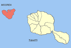
Location of the commune (in red) within the Windward Islands. The atoll of Maiao lies outside of the map. Administration Country France Overseas collectivity French Polynesia Administrative subdivision Windward Islands Mayor Teriitepaiatua Maihi Statistics Elevation 0–1,207 m (0–3,960 ft) Land area 141.8 km2 (54.7 sq mi) Population1 16,490 (August 2007 census) - Density 116 /km2 (300 /sq mi) INSEE/Postal code 98729/ 98728 1 Population without double counting: residents of multiple communes (e.g., students and military personnel) only counted once. Coordinates: 17°31′35″S 149°49′05″W / 17.526303°S 149.817978°W
Moorea-Maiao is a commune of French Polynesia, an overseas territory of France in the Pacific Ocean. The commune is in the administrative subdivision of the Windward Islands.
The commune of Moorea-Maiao is made up of the island of Moorea (133 km²/51 sq. miles; 16,191 inhabitants at the 2007 census) and the much smaller atoll of Maiao (8.8 km²/3.4 sq. miles; 299 inhabitants at the 2007 census),[1] located 78 km (48 mi) southwest of Moorea. The administrative centre of the commune is the settlement of Afareaitu, on the island of Moorea.
References
- ^ (French) Institut Statistique de Polynésie Française (ISPF). "TABLEAU II Population des communes et communes associées de Polynésie française" (PDF). Archived from the original on 2008-02-29. http://web.archive.org/web/20080229183317/http://www.ispf.pf/(k1aciwf4z0fyap45ghzhgm55)/stat/demo/rp2007/pdfs/poplegales_commass2007.pdf. Retrieved 2007-12-02.
Categories:- Communes of French Polynesia
- French Polynesia geography stubs
Wikimedia Foundation. 2010.
