- Maiao
-
Coordinates: 17°39′S 150°38′W / 17.65°S 150.633°W
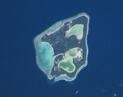
Maiao is an 8.8 km2 (3.4 sq mi) island formation located 78 km (48 mi) southwest of Moorea and one of the Windward Islands (French: Îles du Vent) in French Polynesia.
Geography
The island formation consists of one high island with a peak elevation of 154 meters (505') and a low island (or motu) that winds along the base of the high island. The formation encloses two hypersaline lagoons called Roto Iti and Roto Rahi. The island also has a lagoon at its edge. All lagoons are connected through narrow channels. The island is home to 299 people (as of Aug. 2007 census).[1]
Administration
The island is administratively part of the commune (municipality) of Moorea-Maiao, itself in the administrative subdivision of the Windward Islands.
References
- ^ (French) Institut Statistique de Polynésie Française (ISPF). "TABLEAU II Population des communes et communes associées de Polynésie française" (PDF). Archived from the original on 2008-02-29. http://web.archive.org/web/20080229183317/http://www.ispf.pf/(k1aciwf4z0fyap45ghzhgm55)/stat/demo/rp2007/pdfs/poplegales_commass2007.pdf. Retrieved 2007-12-02.
- Maiao at Oceandots.com (accessed June 22, 2006)
- Lesser known Society Islands at colonialvoyage.com (accessed Oct. 22, 2006)] (includes image)


Archipelagos of French Polynesia: Australs • Gambiers • Marquesas • Societies • Tuamotus Categories:- Islands of the Society Islands
- French Polynesia geography stubs

Wikimedia Foundation. 2010.