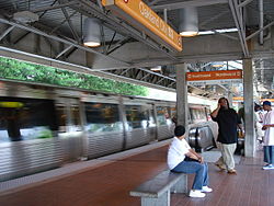
- Oakland City (MARTA station)
-
Oakland City
MARTA rapid transit station
Station statistics Address 1400 Lee Street SW
Atlanta, GA 30310Coordinates 33°43′01″N 84°25′31″W / 33.716848°N 84.4252°WCoordinates: 33°43′01″N 84°25′31″W / 33.716848°N 84.4252°W Lines Structure Elevated Platforms 1 island platform Tracks 2 Parking 337 spaces; Free daily parking Bicycle facilities 8 spaces Other information Opened December 15, 1984 Accessible 
Code S3 Breeze Card Yes Services Preceding station MARTA Following station toward AirportRed Line toward North SpringsGold Line toward DoravilleOakland City is an elevated Rail station on the Red and Gold lines of the Metropolitan Atlanta Rapid Transit Authority (MARTA) rail system. It has one island platform between two tracks. It was opened on December 15, 1984. For both entrances to this station, you have to go through the fare gates and an underground passageway to go up to the platform. On the Lee St. entrance (on the west side of station), you go through fare gates, then the passageway goes under the street. From the other side, the passageway goes under the street and freight line tracks. It is located on the border of the Oakland City and Capitol View neighborhoods in Atlanta. It has an at grade style though its nature is elevated, similar to many of those stations on the East-West line.
Like the West End Station, it also serves many neighborhoods in Southwest Atlanta, including those on Campbellton Road, Sylvan Road & Dill Ave. It provides connecting bus service to Atlanta Christian College, Barge Road Park n' Ride, and Greenbriar Mall.
Taxi Stand/Parking Lot and Station House
Bus routes
- Route 83 - Campbellton / Greenbriar
- Route 162 - Headland Drive / Alison Court
- Route 172 - Sylvan Road / Virginia Avenue
- Route 193 - Sylvan Hills
External links
Categories:- MARTA stations
- Railway stations opened in 1984
- Railway stations in Atlanta, Georgia
- Atlanta, Georgia stubs
- Rapid transit stubs
Wikimedia Foundation. 2010.

