- Buckland Airport
-
Buckland Airport 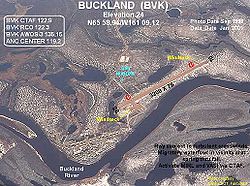
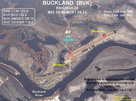
IATA: BKC – ICAO: PABL – FAA LID: BVK Summary Airport type Public Owner State of Alaska DOT&PF - Northern Region Serves Buckland, Alaska Elevation AMSL 31 ft / 9 m Coordinates 65°58′54″N 161°08′57″W / 65.98167°N 161.14917°W Runways Direction Length Surface ft m 11/29 3,200 975 Gravel Source: Federal Aviation Administration[1] Buckland Airport (IATA: BKC, ICAO: PABL, FAA LID: BVK, formerly 7K5) is a state-owned public-use airport located one nautical mile (1.85 km) southwest of the central business district of Buckland,[1] a city in the Northwest Arctic Borough of the U.S. state of Alaska. The airport is situated on the Buckland River.
Although most U.S. airports use the same three-letter location identifier for the FAA and IATA, this airport is assigned BVK by the FAA[1] and BKC by the IATA[2] (which assigned BVK to Huacaraje, Bolivia[3]). The airport's ICAO identifier is PABL.[4]
Contents
Facilities and aircraft
Buckland Airport covers an area of 184 acres (74 ha) at an elevation of 31 feet (9 m) above mean sea level. It has one runway designated 11/29 with a gravel surface measuring 3,200 by 75 feet (975 x 23 m).[1]
Airlines and non-stop destinations
Airlines Destinations Bering Air Deering, Kotzebue[5] Era Alaska Kotzebue [6] References
- ^ a b c d FAA Airport Master Record for BVK (Form 5010 PDF), effective 2009-07-02.
- ^ Great Circle Mapper: BKC / PABL - Buckland, Alaska
- ^ Great Circle Mapper: BVK / SLHJ - Huacaraje, Bolivia
- ^ "Alaskan ICAO Identifiers". Federal Aviation Administration. http://www.faa.gov/air_traffic/publications/atpubs/LID/L_G2.htm. Retrieved 2009-08-07.
- ^ Bering Air: Kotzebue Flight Schedule (PDF). Retrieved 29-Aug-2007.
- ^ Era Alaska Timetable (PDF). Retrieved April 17, 2011.
External links
- FAA Alaska airport diagram (GIF)
- FAA Terminal Procedures for BVK, effective 20 October 2011
- Resources for this airport:
- AirNav airport information for PABL
- ASN accident history for BKC
- FlightAware airport information and live flight tracker for PABL
- NOAA/NWS latest weather observations for PABL
- SkyVector aeronautical chart for BVK
Categories:- Airports in Northwest Arctic Borough, Alaska
Wikimedia Foundation. 2010.