- Valdez Airport
-
Valdez Airport
Pioneer Field
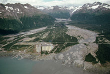
Valdez Airport, left background, as seen in an aerial photo taken 1974 IATA: VDZ – ICAO: PAVD – FAA LID: VDZ Summary Airport type Public Operator State of Alaska DOT&PF - Northern Region Serves Valdez, Alaska Elevation AMSL 121 ft / 37 m Coordinates 61°08′02″N 146°14′54″W / 61.13389°N 146.24833°W Runways Direction Length Surface ft m 6/24 6,500 1,981 Asphalt Statistics (2008) Aircraft operations 13,000 Based aircraft 31 Source: Federal Aviation Administration[1] Valdez Airport (IATA: VDZ, ICAO: PAVD, FAA LID: VDZ)[2], also known as Pioneer Field, is a state-owned public-use airport located three nautical miles (6 km) east of the central business district of Valdez, a city in the Valdez-Cordova Census Area of the U.S. state of Alaska.[1]
Contents
Facilities and aircraft
Valdez Airport covers an area of 140 acres (57 ha) at an elevation of 121 feet (37 m) above mean sea level. It has one asphalt paved runway designated 6/24 which measures 6,500 by 150 feet (1,981 x 46 m).[1]
For the 12-month period ending January 1, 2008, the airport had 13,000 aircraft operations, an average of 35 per day: 50% air taxi, 42% general aviation and 8% military. At that time there were 31 aircraft based at this airport: 65% single-engine, 3% jet, 23% helicopter and 10% ultralight.[1]
Airline and destination
there is no schedudled flights to any city
References
- ^ a b c d FAA Airport Master Record for VDZ (Form 5010 PDF), effective 2008-06-05
- ^ Great Circle Mapper: VDZ/PAVD - Valdez, Alaska
External links
- FAA Alaska airport diagram (GIF)
- FAA Terminal Procedures for VDZ, effective 20 October 2011
- Resources for this airport:
- AirNav airport information for PAVD
- ASN accident history for VDZ
- FlightAware airport information and live flight tracker for PAVD
- NOAA/NWS latest weather observations for PAVD
- SkyVector aeronautical chart for VDZ
Categories:- Airports in the Valdez–Cordova Census Area, Alaska
- Alaska airport stubs
Wikimedia Foundation. 2010.
