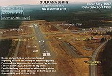
- Gulkana Airport
-
Gulkana Airport 
IATA: GKN – ICAO: PAGK – FAA LID: GKN Summary Airport type Public Operator State of Alaska DOT&PF Location Gulkana, Alaska Elevation AMSL 1,580 ft / 481.6 m Coordinates 62°09′18″N 145°27′24″W / 62.155°N 145.45667°WCoordinates: 62°09′18″N 145°27′24″W / 62.155°N 145.45667°W Runways Direction Length Surface ft m 14/32 5,000 1,524 Asphalt Gulkana Airport (IATA: GKN, ICAO: PAGK, FAA LID: GKN) is a public airport located eight miles (13 km) southwest of the central business district (CBD) of Gulkana and five miles (8 km) northeast of Glenallen, in the Valdez-Cordova Census Area of the U.S. state of Alaska. The airport covers 1,678 acres (679 ha) and has one runway.
Airline
Airline service is subsidized by the Essential Air Service program.
- Ellis Air Taxi (Anchorage) (McCarthy)
References
External links
- Ellis Air Taxi
- Alaska FAA Airport Diagram (GIF)
- Resources for this airport:
- AirNav airport information for PAGK
- ASN accident history for GKN
- FlightAware airport information and live flight tracker for PAGK
- NOAA/NWS latest weather observations for PAGK
- SkyVector aeronautical chart for GKN
- Essential Air Service documents (Docket Number 492) from the U.S. Department of Transportation:
Categories:- Essential Air Service
- Airports in the Valdez–Cordova Census Area, Alaska
- Alaska airport stubs
Wikimedia Foundation. 2010.
