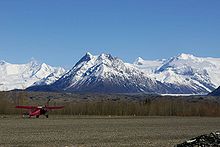
- McCarthy Airport
-
McCarthy Airport 
IATA: MXY – ICAO: PAMX – FAA LID: 15Z Summary Airport type Public Operator State of Alaska DOT&PF Location McCarthy, Alaska Elevation AMSL 1,531 ft / 466.6 m Coordinates 61°26′13″N 142°54′13″W / 61.43694°N 142.90361°WCoordinates: 61°26′13″N 142°54′13″W / 61.43694°N 142.90361°W Runways Direction Length Surface ft m 1/19 3,500 1,067 Gravel McCarthy Airport (IATA: MXY, ICAO: PAMX, FAA LID: 15Z) is a public airport located one mile (2 km) northeast of the central business district (CBD) of McCarthy, Alaska, USA. It has two gravel runways and is built for small planes. In winter it is maintained irregularly. An average of 27 planes fly through it in a week.
Airline
- Ellis Air Taxi (Gulkana) - subsidized by the Essential Air Service program
- Wrangell Mountain Air (Chitina) - Service available May 15 to Sept. 15
References
External links
- Alaska FAA airport diagram (GIF)
- Resources for this airport:
- AirNav airport information for PAMX
- ASN accident history for MXY
- FlightAware airport information and live flight tracker for PAMX
- NOAA/NWS latest weather observations for PAMX
- SkyVector aeronautical chart for 15Z
- Essential Air Service documents (Docket Number 2009) from the U.S. Department of Transportation:
Categories:- Essential Air Service
- Airports in the Valdez–Cordova Census Area, Alaska
- Alaska airport stubs
Wikimedia Foundation. 2010.
