- Markland Locks and Dam
-
Markland Locks and Dam 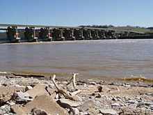
Markland Locks and Dam (gates open)Location  Gallatin County, Kentucky / Switzerland County, Indiana USA
Coordinates 38°46′29″N 84°57′51″W / 38.77472°N 84.96417°W Construction began March 1956 Opening date June 1964 Dam and spillways Length 1395 ft (425.2 m) Impounds Ohio River Bridge Vertical clearance no overhead clearance Toll Free The Markland Locks and Dam is a concrete dam bridge and locks that span the Ohio River. It is 1395 feet (425.2 m) long, and connects Gallatin County, Kentucky, and Switzerland County, Indiana.
The locks and dam were reviewed by the Board of Engineers for River and Harbours to replace the Ohio River locks and dams Number 35, 36, 37, 38 and 39. Then the project was approved by the Secretary of the Army on March 11, 1953. Construction on the locks began in March 1956 and they were placed in operation in May 1959. The dam construction began in April 1959 and was finished in June 1964.
Federal Power Commission granted a license for Cinergy to operate a hydroelectric power plant at the dam. The plant has a capacity of 81,000 kVA.[1]
On September 27, 2009, the 1,200-foot lock failed and the gates "mismitered" due to a solenoid malfunction. The lock was repaired and reopened on March 1, 2010. The 1,200-foot lock chamber remained closed for 155 days, but the 600-foot lock continued to lock traffic albeit with delays Corps.[2]
Contents
See also
References
External references
References
- ^ United States Army Corps of Engineers: Louisville District
- ^ United States Army Corps of Engineers: Louisville District
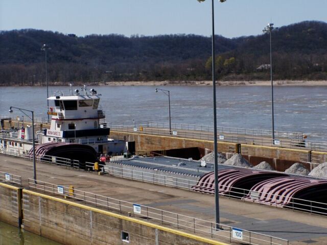
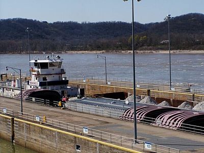 Steven J Mason (Ingram Barge Co.) locking through.
Bridges of the Ohio River Upstream
Carroll C. Cropper Bridge

Markland Locks and Dam
 KY 1188
Downstream
Milton-Madison Bridge

Power stations in Indiana Coal-fired
generating stationsA.B. Brown • Bailly • Cayuga • Clifty Creek • Crawfordsville Mun. • F.B. Culley • Eagle Valley • Edwardsport • R. Gallagher • Gibson • Harding St. (formerly E.W. Stout) • Jasper Mun. • Logansport • Merom • Michigan City • D.H. Mitchell • Noblesville • Perry K. • Peru Mun. • Petersburg • H.T. Pritchard • F.E. Ratts • Rockport • R.M. Schahfer • State Line • Tanner's Creek • Wabash River • Warrick • Whitewater ValleyOil-fired peaking stations Connersville • Miami-WabashGas-fired peaking stations Anderson • Broadway • Georgetown • Henry County • Lawrence County • Lawrenceburg • Montpelier • Noblesville • Northeast • Portside • Richmond • Vermillion • Wheatland • Whiting Clean Energy • WorthingtonHydroelectric dams Markland Dam • Norway Dam • Oakdale Dam • Twin Branch DamWind farms Biomass to energy plants Attempted nuclear plants Utility companies Duke Energy Indiana • Hoosier Energy • Indiana-Michigan Power • Indianapolis Power & Light • NiSource • VectrenDuke Energy Indiana Coal-fired stations Peaking stations Connersville • Henry County • Miami-Wabash • Noblesville • WheatlandDams Markland DamCoordinates: 38°46′29″N -84°57′57.71″E / 38.77472°N 83.0339694°W
Categories:- Dams in Indiana
- Dams in Kentucky
- Hydroelectric power plants in Indiana
- Hydroelectric power plants in Kentucky
- Buildings and structures in Gallatin County, Kentucky
- Ohio River
- Buildings and structures in Switzerland County, Indiana
- Bridges completed in 1964
- Transportation in Switzerland County, Indiana
- Road bridges in Indiana
- Road bridges in Kentucky

Wikimedia Foundation. 2010.