- GNR Derbyshire and Staffordshire Extension
-
The GNR Derbyshire and Staffordshire Extension, locally known as the (Derby) Friargate Line is a now closed railway line that was part of the Derbyshire and Staffordshire extension of the Great Northern Railway. It linked Nottingham and Grantham to the east of the East Midlands counties to Burton upon Trent to the south west of the area. The route cut a direct line through the midlands industrial city of Derby whereupon an impressive warehouse was constructed, large sidings and the pretty Derby Friargate Station. The line had such an impact on Derby, Friargate and the surrounding areas that it became known as the Derby Friargate Line.
The GNR acquired the Stafford and Uttoxeter Railway in July 1881 gaining a through route from Grantham to Wales via the Ambergate, Nottingham, Boston and Eastern Junction Railway.
Contents
History of the line
Businessmen and councillors alike (which at the time often amounted to one and the same thing), wanted to exploit the coal seams around northern Nottinghamshire and Derbyshire, the rail transport of which was controlled by the Midland Railway company which dictated prices; this increased the price of coal dramatically and it was agreed diminished Derby's competitive position as a Midlands industrial town. So eager were Councillors and the general powers that be, to have a second railway line serve Derby, that when the Act ((the Great Northern (Derbyshire and Staffordshire) Act of 1872)), authorising its creation was passed by Parliament, it contained very little protection for local residents. A route had been agreed that practically sliced through the city from East to West and it was not until construction began that the people of Derby belatedly realised what had been signed up to. The Great Northern Railway had carte blanche authority to do practically whatever it needed to complete the route as economically as possible. In fact, looking at an aerial view of the city today, the route of the line can still be made out, almost 50 years after it was closed.
 GNR Derbyshire and Staffordshire Extension
In particular the residential areas around Friargate and South Street were affected, with South Street actually losing almost half its length and truncated by the embankment carrying the Permanent Way. A worse fate was in store for what was Baxter Street which vanished completely beneath the Great Northern Railway's yard and warehouse. Similarly, Short Street and Cherry Street were demolished to make way for the line. In the case of South Street, the railway company sought to appease the dissatisfaction of residents by building a cast iron footbridge connecting Ponsonby Terrace and Dog Kennel Lane (Great Northern Road). However this was not a particularly satisfactory solution; the problem for Derby Council was that as the railway company had signed up to nothing legally binding to protect the integrity of the area or interests of the residents, any requirements covering such factors had to be done by consent of the Great Northern via mutual agreement with the Council. The result was not a particularly happy relationship!
In addition Uttoxeter Old Road had to be raised above the railway at the point where it was eight tracks wide, creating an awkwardly steeped road and a difficult junction with Parcel Terrace as well as resulting in the demolition of more of the original Victorian terraced housing.
Route of the line through Derby
Ilkeston to Friargate
From East to West, the line crossed the famous Bennerley Viaduct (which still stands today) and then headed towards the Derbyshire village of Morley where it cut a route through Morley Tunnel (238 yds) emerging towards Breadsall where a fine country station was built to the same model of those at Mickleover and Etwall. The line then continued on an embankment adjacent to Derby Race Course and then a viaduct (blown up in 1979) carrying the line towards Chester Green, then below several streets being; North Parade, North Street, Arthur Street, Henry Street, Edward Street and King Street whereupon it was carried over an arched bridge over Brook Street and Agard Street to Friargate Station. This is where the railway usurped Short Street which, as the name suggests, was a short street linking Agard Street to Friargate, which vanished beneath the arches carrying the railway. These arches were later used as the depot for Derby Tramway Company.
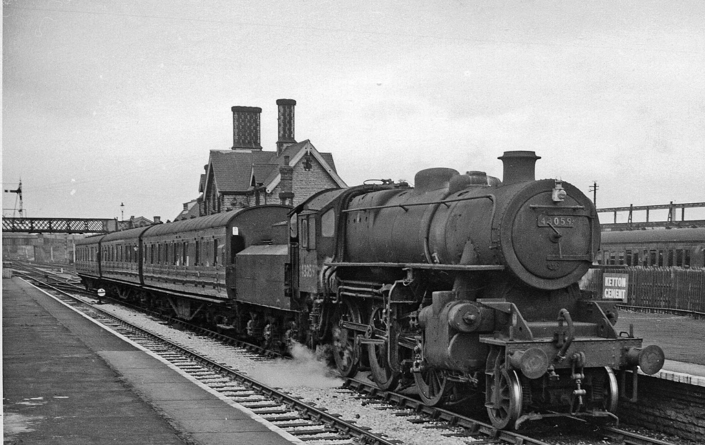
 The 17.18 Nottingham (Victoria) to Derby (Friargate) service at Basford North in 1963
Friargate to Egginton Junction
On leaving Friargate Station westbound, the line passed underneath the aforementioned Uttoxeter Old Road and then parallel to Slack Lane, adjacent to where the Sainsbury's site now stands, under an extant road bridge (now carrying just a pavement), which used to carry Kingsway and then through Mickleover Tunnel (464 yds). On emerging from the tunnel in a cutting the line then ran under a bridge carrying Station Road and into Mickleover (for Radbourne) Station. Both the station buildings and The Great Northern Hotel, a pub on the other side of Station Road are extant, but the tunnel entrance and cutting as far as the Western side of Station road were infilled with land fill in the early nineteen eighties. The bridge carrying Station Road is still there and there is a small hump in the road as it passes over it, but whereas there would once have been a cutting containing the railway the ground adjacent to the bridge is now at ground level, sloping steeply towards the station on the western side of the bridge. The line then ran through fields and into Etwall which had a country station almost identical to those at Mickleover and Breadsall, thence running south into Egginton and the junction with the main line from Derby to Crewe.
References
Further reading
- Henshaw, Alfred (2000). The Great Northern Railway in the East Midlands. RCTS. ISBN 0-9011-1588-6.
External links
This part of the line became British Rail's test track between 1965 and 1990 - see here for more information about the test track.
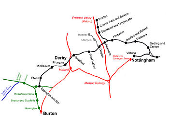
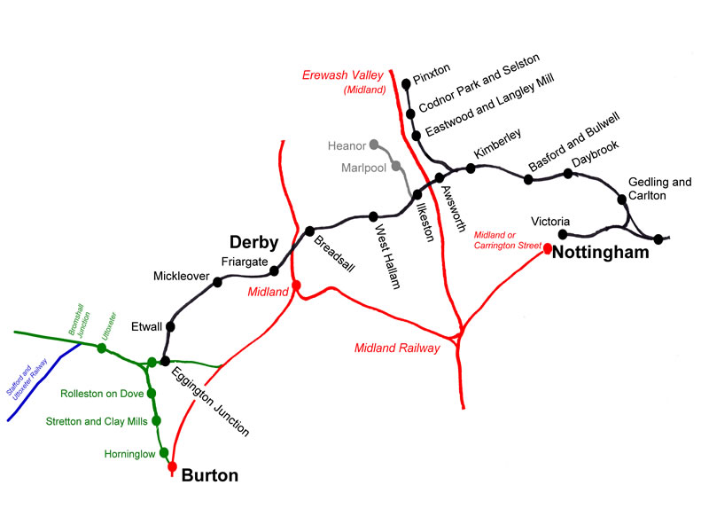
Complete route map of the GNR Derbyshire and Staffordshire Extension (Friargate Line)
On the following webpage you can follow the entire route of the former Friargate line using a modern interactive map. The route (marked with a blue transparent line) has been overlayed on top of a modern map with satellite imagery. This allows you to see its exact route from Egginton to Nottingham. Along the route various points of interest are marked with clickable markers to reveal more information on all the bridges, Tunnels and the serving stations.
Categories:- Closed railway lines in the East Midlands
- Great Northern Railway (Great Britain)
- Rail transport in Derby
- Rail transport in Derbyshire
- Rail transport in Nottinghamshire
- Railway lines opened in 1878
Wikimedia Foundation. 2010.