- Cheorwon
-
This article is about the South Korean county. For the DPRK's neighboring kun of the same name (formerly Anhyŏp), see Chorwon.
Cheorwon
철원— County — Korean transcription(s) - Hangul 철원군 - Hanja 鐵原郡 - Revised Romanization Cheorwon-gun - McCune-Reischauer Ch'ŏrwŏn-gun 
Emblem of Cheorwon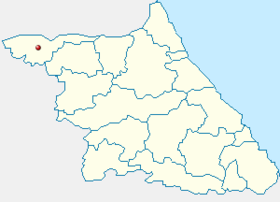
Country  South Korea
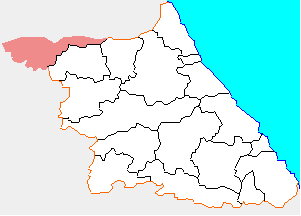
Region Gwandong Administrative divisions 4 eup, 3 myeon Area - Total 899.82 km2 (347.4 sq mi) Population (2001) - Total 54,040 - Density 60.05/km2 (155.5/sq mi) - Dialect Gangwon Cheorwon County (Cheorwon-gun), also spelt Cholwon, is a county in Gangwon Province, South Korea. It is located right next to the border with North Korea.
Contents
History
- Goguryeo - First named Moeuldongbi.
- Silla Dynasty - name changed to Cheolseong.
- During the Later Three Kingdoms Period of Korea, Gung Ye determined it capital of Taebong.
- Goryeo Dynasty
- In 918, during the rule of King Taejo of Goryeo, its name was changed to Cheorwon and then renamed as Dongju.
- Joseon Dynasty
- King Taejong changed its name into 'Dohobu'.
- In 26th year of King Sejong's reign (1434), it was transferred from Gyeonggi-do to Gangwon.
- On May 26 of the King Gojong, altered to Chuncheon-bu.[1]
Symbol
- County Tree : Korean Nut Pine
- County Flower : Royal Azalea
- County Bird : Crane
Location
Cheorwon plays an important role in providing passage from Seoul to Wonsan and Kumgangsan
Since the expansion of the 43 National Road which connects Cheorwon and Seoul, the ease of transportation has been improved greatly. [2]
Climate
Climate data for Cheorwon (1981−2010) Month Jan Feb Mar Apr May Jun Jul Aug Sep Oct Nov Dec Year Average high °C (°F) 0.7
(33.3)4.2
(39.6)9.8
(49.6)17.5
(63.5)22.5
(72.5)26.2
(79.2)27.7
(81.9)28.7
(83.7)24.8
(76.6)18.9
(66.0)10.4
(50.7)3.1
(37.6)16.2 Daily mean °C (°F) −5.5
(22.1)−2.3
(27.9)3.5
(38.3)10.4
(50.7)16.3
(61.3)20.8
(69.4)23.5
(74.3)23.8
(74.8)18.7
(65.7)11.5
(52.7)4.1
(39.4)−2.8
(27.0)10.2 Average low °C (°F) −11.4
(11.5)−8.3
(17.1)−2.5
(27.5)3.3
(37.9)10.3
(50.5)15.9
(60.6)20.0
(68.0)19.9
(67.8)13.5
(56.3)5.3
(41.5)−1.3
(29.7)−8.1
(17.4)4.7 Precipitation mm (inches) 20.6
(0.811)26.4
(1.039)40.2
(1.583)64.0
(2.52)102.0
(4.016)138.0
(5.433)400.9
(15.783)338.2
(13.315)148.5
(5.846)44.7
(1.76)46.4
(1.827)21.2
(0.835)1,391.2
(54.772)% humidity 68.9 64.9 62.6 58.9 65.5 72.1 80.7 79.9 76.8 72.9 71.1 70.6 70.4 Avg. precipitation days (≥ 0.1 mm) 7.3 6.3 7.9 8.0 9.7 11.3 17.0 14.1 8.7 6.8 7.7 7.9 112.7 Sunshine hours 161.4 166.3 178.7 195.8 207.8 178.4 128.4 165.0 178.6 192.5 147.7 149.4 2,050.1 Source: Korea Meteorological Administration [3] Sister cities
See also
References
- ^ :: Welome to Cheorwon county! ::
- ^ :: Welome to Cheorwon county! ::
- ^ "평년값자료(1981−2010) 철원(95)". Korea Meteorological Administration. http://www.kma.go.kr/weather/climate/average_30years.jsp?yy_st=2011&stn=95&norm=M&x=22&y=3&obs=0&mm=5&dd=2. Retrieved 2011−05−02.
- ^ 제주특별자치도 서귀포시 방문을 환영합니다
External links
Gangwon 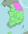
Capital Cities Counties Coordinates: 38°12′33″N 127°13′03″E / 38.20917°N 127.2175°E
Categories:- Cheorwon
- Counties of Gangwon

Wikimedia Foundation. 2010.