- Teton Dam
Infobox_Dam
dam_name = Teton Dam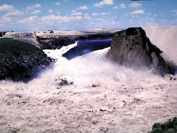
caption = The reservoir behind the Teton Dam was emptied within hours of the initial breach
official_name = Teton Dam
crosses =Snake River
reservoir = Teton Reservoir
locale =Eastern Idaho
maint =United States Bureau of Reclamation
length = convert|3100|ft|m
height = convert|305|ft|m
width = convert|1700|ft|m
began = 1975
open = 1976
cost = $3,825,849
reservoir_capacity = convert|234259|acre feet
bridge_id =
map_cue =
map_
map_text =
map_width =
coordinates =
extra =The Teton Dam was a federally built earthen dam on the Teton River in southeastern
Idaho in theUnited States which existed for less than one year before suffering a catastrophic failure onJune 5 ,1976 . The collapse of the dam resulted in the deaths of 11 peoplecite news|url=http://www.cnn.com/2007/LIVING/wayoflife/07/26/mf.gov.projects/index.html|title=5 of the largest, oddest and most useless state projects|work=CNN|author= Doug Cantor|date=27 Jul 2007|accessdate=2007-07-29] and 13,000 head of cattle. The dam cost about USD $100 million to build, and the federal government paid over $300 million in claims related to the dam failure. Total damage estimates have ranged up to $2 billion.cite book|title=Cadillac Desert |author=Marc Reisner|isbn=0-14-017824-4|year=1993|pages=407] The dam was never rebuilt.Geology
The dam site is located in the eastern
Snake River Plain , which is a broad tectonic depression on top of rhyolitic ash-flowtuff . The tuff, a late-Cenozoic volcanic rock dating to about 1.9 million years, sits on top ofsedimentary rock . The area is very permeable, highly fissured and unstable. Test boreholes, drilled by Bureau engineers and geologists, showed that one side of the canyon was highly fissured, a condition unlikely to be remediated by the Bureau's favoured method of "grouting" (injecting concrete into the substrates under high pressure).No seepage was noted on the dam itself before the date of the collapse. However, on June 3, 1976 workers found two small springs had opened up downstream.The collapse and immediate aftermath
At the time of the collapse, spring runoff had almost filled the new reservoir to capacity, with a maximum depth of convert|240|ft|m. Water began seeping from the dam on the Thursday before the collapse, an event not unexpected for an earthen dam.
At 7:30 a.m. on Saturday, June 5, a muddy leak appeared, suggesting sediment was in the water, but engineers didn't believe there was a problem. By 9:30 a.m. the downstream face of the dam had a wet spot on it and embankment material began to wash out. Crews with
bulldozer s were sent to plug the leak, but were unsuccessful. Local media appeared at the site, and at 11:15 officials told the county sheriff's office to evacuate downstream residents. Work crews were forced to flee on foot as the widening gap swallowed their equipment. The operators of two bulldozers caught in the eroding embankment were pulled to safety withrope s. At 11:55 a.m.Mountain Daylight Time (UTC-6:00), the top of the dam collapsed; two minutes later the remainder disintegrated. By 8:00 p.m. that evening, the reservoir had completely emptied.The communities immediately downstream, Rexburg, Wilford, Sugar City, Salem, and Hibbard, suffered horribly. Thousands of homes and businesses were destroyed. One estimate placed damage to Rexburg, population 10,000, at 80 percent of existing structures. The small community of Sugar City was literally wiped from the river bank. To the southwest, communities such as Roberts on a lower section of the Snake River received significant damage. The city of Idaho Falls, even further down on the flood plain, had time to prepare. At the old and unstable
American Falls Dam downstream, engineers released a significant volume of water before the flood arrived. That dam held, and the flood was over, but tens of thousands of acres of land near the river were stripped of topsoil. Cleaning up took the rest of the summer.Rebuilding and claims
After the dam's collapse, cleanup and rebuilding of damaged property continued for several years. Within a week after the disaster, President
Gerald Ford requested a $200 million appropriation for initial payments for damages, without assigning responsibility for Teton Dam’s failure.Fact|date=July 2007 The dam was never rebuilt.The Bureau of Reclamation set up claims offices in Rexburg, Idaho Falls, and Blackfoot. Disaster victims filed over 4,800 claims by January 4, 1977, totalling $194 million. The Federal government paid 3,813 of those claims, $93.5 million, by that date.
Originally scheduled to end in July 1978, the Claims Program continued into the 1980s. At the end of the Claims Program in January 1987, the Federal government had paid 7,563 claims for a total amount of $322 million.
Cause of the collapse
A wide-ranging controversy erupted from the dam's collapse. According to the Bureau of Reclamation, blockquote|Today, Bureau of Reclamation engineers assess all Reclamation dams under strict criteria established by the Safety of Dams program. Each structure is periodically reviewed for resistance to seismic stability, internal faults and physical deterioration. [cite web|title=The Failiure of Teton Dam|publisher=Bureau of Reclamation|url=http://www.usbr.gov/pn/about/Teton.html|accessdate=2007-07-29]
However, it is arguable that the tragedy was preventable. There were four key reasons, known prior to construction, why the Teton Dam should not have been built in the first place:
:1. it failed cost-benefit analysis, delivering irrigation water at prices far out of reach of local farmers;:2. supposed flood control benefits were illusory, in light of subsequent events tragically so;:3. a significant number of local interests did not want it built and challenged the legality of it in court;:4. it was sited in an area of known instability.
The fact that the Bureau, and state officials, nevertheless insisted that the dam be built remains a blot on the reputations of all concerned.
Notes
ee also
*
Buffalo Creek Flood
*Johnstown Flood
*St. Francis Dam
*Kelly Barnes Dam External links
* [http://www.usbr.gov/dataweb/html/teton.html The Teton Basin Project] , Eric A. Stene, Bureau of Reclamation History Program, 1996
* [http://www.usbr.gov/pn/about/Teton.html US Bureau of Reclamation site with several photos]
* [http://www.geol.ucsb.edu/faculty/sylvester/Teton%20Dam/narrative.html Informative geology site at the U of California, Santa Barbara]
* [http://www.usbr.gov/pn/about/tetonmit.html More geology, US Bureau of Reclamation]
* [http://www.lib.utah.edu/spc/photo/p211/p211.html University of Utah site with many gripping photographs]
* [http://www.idahoptv.org/outdoors/shows/bofr/teton/brown.html "The Bureau That Changed the West" One That Got Away: Teton Dam] (site critical of USBR)
* [http://www.rexcc.com/thingstodo/attractions/tetonflood.html Teton Dam Flood Museum, Rexburg, Idaho]
* [http://abish.byui.edu/specialCollections/Manuscripts/Collections/CollMss2.htm Teton Dam Collection - Oral History reports and newspaper articles] , includes more than 50 oral history interviews of those living in the area when the disaster occurred.
* [http://www.geol.ucsb.edu/faculty/sylvester/Teton%20Dam/Teton%20Dam.html Mrs. Olsons Slides showing progressive dam erosion damage]
* [http://www.zebpalmer.com/2006/06/09/teton-dam-failure-actual-data-for-american-falls/ Data from American Falls Dam (downstream) from the Teton Dam Failure]
Wikimedia Foundation. 2010.