- Monkman Provincial Park
-
Monkman Provincial Park is a provincial park in British Columbia, Canada south of the communities of Tumbler Ridge and Chetwynd, British Columbia and northeast of Prince George.[1]
Contents
History
Monkman Provincial Park was named after Alexander Monkman, an individual who expended a considerable amount of effort attempting to build a transportation route from the Peace River (Canada) farming country down to the Pacific ports. In 1922, he and a group of fur trappers discovered what is now known as Monkman Pass. It was this pass that provided him with his vision for a railroad as a direct and economical route south. Failing to get government support for his venture, Monkman focused on the alternative—building a highway. The Monkman Pass Highway Association was formed in 1936, and over the next three years, many determined volunteers laboured to blaze this new trail. Limited funding, harsh conditions, and the outbreak of the Second World War eventually brought the project to a halt. A railway was later built to the northwest over the Pine Pass, and Monkman’s "highway" slowly faded into historical obscurity. Today, only a few sections are visible along the Monkman Lake Trail, a route that follows parts of the original road. The Brooks Falls in Monkman Provincial Park, was named after Carl Brooks, one of the volunteers who worked along with Alex Monkman and the Highway Association. A cairn marking overlooking the falls has been placed in his honour.
Up until a few years ago, just getting to Monkman was as big an adventure as exploring the park itself. Washed out Forest Service roads with nearly a dozen creek crossings kept access limited to four-wheel-drive vehicles, and only at certain times of the year. Though still fairly rough, the gravel road has been upgraded and bridges have been built, opening up the park to almost all vehicles.
Things to do
Kinuseo Falls
Main article: Kinuseo Falls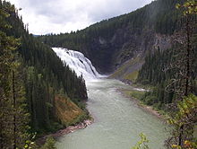 Kinuseo Falls: A geological fault in the course of the Murray River forms a 60 metre cascade.
One of the most outstanding features in Monkman Provincial Park is Kinuseo Falls. At 197 feet (60 metres), Kinuseo Falls is slightly taller than Niagara Falls, though it doesn't move the same volume of water as Niagara. The falls are located a short stroll from any of the campsites in the wild Rocky Mountain Foothills. The campground is also a departure point for people making further explorations into the park.
The Stone Corral
The Stone Corral area of Monkman park was discovered in 1999. A hike to the area takes you through amazing features such as small caves with stalactites, moonsmilk and other limestone formations, ponds and many kinds of moving water, interesting plants, fossils, and magnificent viewpoints. An interpretive brochure has been printed documenting all the areas special features.
The Cascades and Monkman Lake
To the south of the Kinuseo Falls campground lies the main body of Monkman Provincial Park. Access is via the 24-km Monkman Lake Trail, which winds through this portion of the park and provides backpackers and hikers with an opportunity to experience the unspoiled splendour of the area. Small side trails provide scenic views of some of the waterfalls along Monkman Creek. The original trail ended at Monkman Lake, the largest body of water in the park, though as of 2008, the trail has been extended as part of the Monkman Pass Historical Route, but the lake is still the final destination for most people on the trail. Note that mountain bikes are only allowed up to Kilometre 12 on this trail, with horse and llama use not permitted anywhere in the park.
Monkman Pass Historical Trail
Built in 2006 and 2007, the Monkman Pass Historical Trail officially opened Thursday, July 17, 2008. The trail takes six days to hike, and follows part of the old Monkman Pass Highway route. On its way to Monkman Pass, the trail climbs into the alpine (deviating from the original route) to a series of tarns. The route ends at Herrick Creekl, where hikers will either have to turn around and hike back, or arrange for a jetboat to pick them up. This new route is an extension of the Monkman Lake Trail.
See also
- The Green Bowl (gorge near Kinuseo Falls)
References
- ^ "Monkman Park". BC Geographical Names. http://apps.gov.bc.ca/pub/bcgnws/names/25847.html.
Further reading
- Helm, Charles. Tumbler Ridge: Enjoying its History, Trails, and Wilderness MCA Publishing (2001).
External links
- Monkman Provincial Park BC Parks Website
- Tumbler Ridge Website
- BritishColumbia.com Website
- Chetwynd Website
- Kinuseo Falls as featured on DiscoverThePeaceCountry.com
- Town of Tumbler Ridge
Coordinates: 54°36′00″N 121°11′00″W / 54.6°N 121.1833333°W
Categories:- Provincial Parks of British Columbia
- Parks in the Canadian Rockies
- Northern Interior of British Columbia
- Caves of British Columbia

Wikimedia Foundation. 2010.