- Diori Hamani International Airport
-
For other uses, see Nim (disambiguation).
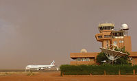
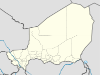
Diori Hamani International Airport IATA: NIM – ICAO: DRRN Location of Airport in Niger Summary Airport type Military/Public Owner Government Location Niamey, Niger Elevation AMSL 732 ft / 223 m Coordinates 13°28′54″N 002°10′13″E / 13.48167°N 2.17028°E Runways Direction Length Surface m ft 09R/27L 3,000 9,843 Bitumen 09L/27R 1,620 5,315 Laterite Sources: Agence pour la Sécurité de la Navigation aérienne en Afrique et à Madagascar[1] Diori Hamani International Airport (IATA: NIM, ICAO: DRRN) is an airport in Niamey, the capital of Niger. It is located in the south eastern suburbs of the city, along the Route Nationale 1, the major highway linking Niamey with the east of the nation. The airport complex also includes the major base for the Armed Forces of Niger's "Armee d'Air".
In 2004, the airport served 97,814 passengers. The Air traffic control for NIM is operated by the ASECNA, which bases one of its five air traffic zones for the continent at Niamey.[2] The airport is named after Hamani Diori, the first President of Niger.
Contents
Airlines and destinations
Airlines Destinations Afriqiyah Airways Bamako, Cotonou, Tripoli (all service is suspended) Air Algérie Algiers Air Burkina Abidjan, Ouagadougou Air France Paris-Charles de Gaulle Air Mali Bamako ASKY Airlines Abidjan, Lomé, Ouagadougou Royal Air Maroc Casablanca Senegal Airlines Dakar, Bamako EAMAC
ASECNA operates the "African School for Meteorology and Civil Aviation/Ecole Africaine de la Météorologie et de l'Aviation Civile" at the Niamey airport complex, as well as in the Plateau quarter of Niamey city centre. Founded in 1963, EAMAC trains civil aviation professionals and aviation meteorologists from across Africa.[3][4]
See also
References
- ^ Aeronautical chart
- ^ Visites du ministre des Transports et de l'Aviation Civile à l'aéroport international Diori Hamani de Niamey et au CNUT: s'enquérir des conditions de travail des agents. Seini Seydou Zakaria, le Sahel] (Niamey) 18 June 2009
- ^ L'EAMAC. asecna.aero Accessed 2009-06-18
- ^ L'EAMAC, c'est la Météorologie, l'Aviation Civile, l'Electronique et l'Informatique au service de la Sécurité de la Navigation Aérienne. Official website. Accessed 2009-06-18
External links
- Accident history for NIM at Aviation Safety Network
- Airport information for DRRN at Great Circle Mapper. Source: DAFIF (effective Oct. 2006).
- Current weather for DRRN at NOAA/NWS
- Airport information for DRRN at World Aero Data. Data current as of October 2006.Source: DAFIF.
- ais-asecna.org Aeronautical charts for NIAMEY/Diori Hamani (DRRN).
 Airports in NigerMano Dayak International Airport · Diori Hamani International Airport · Arlit Airport · Diffa Airport · Dirkou Airport · Dogondoutchi Airport · Dosso Airport · Gaya Airport · Goure Airport · Iferouane Airport · La Tapoa Airport · Maine-Soroa Airport · Maradi Airport · Ouallam Airport · Tahoua Airport · Téra Airport · Tessaoua Airport · Tillabery Airport · Zinder AirportCategories:
- Niger geography stubs
- West African airport stubs
- Airports in Niger
- Buildings and structures in Niamey
Wikimedia Foundation. 2010.


