- Morar railway station
-
Morar 
Mòrar 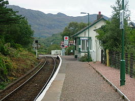
Morar railway station, looking towards the level crossing and Arisaig Location Place Morar Local authority Highland Coordinates 56°58′12″N 5°49′19″W / 56.970°N 5.822°WCoordinates: 56°58′12″N 5°49′19″W / 56.970°N 5.822°W Operations Station code MRR Managed by First ScotRail Number of platforms 1 Live arrivals/departures and station information
from National Rail EnquiriesAnnual rail passenger usage 2002/03 * 3,548 2004/05 *  3,556
3,5562005/06 * 3,6462006/07 * 4,0092007/08 *  3,733
3,7332008/09 * 3,430History Original company Mallaig Extension Railway of West Highland Railway Pre-grouping North British Railway Post-grouping LNER 1 April 1901 Station opened[1] National Rail - UK railway stations A B C D E F G H I J K L M N O P Q R S T U V W X Y Z * Annual passenger usage based on sales of tickets in stated financial year(s) which end or originate at Morar from Office of Rail Regulation statistics. Please note: methodology may vary year on year. Morar railway station is a railway station serving the village of Morar in the Highland region of Scotland. This station is on the West Highland Line.
Contents
History
In 1960, the station was allocated a camping coach converted from a Pullman car, which was fitted with a full kitchen, two sleeping compartments and a room with two single beds.[2]
Services
Preceding station  National Rail
Following station Arisaig First ScotRail
West Highland LineMallaig Historical railways Arisaig
Line and Station openNorth British Railway
Mallaig
Line and Station openStation building
The station building is used by West Word.[3]
References
Notes
- ^ Butt (1995)
- ^ "Pullman Cars as Camping Coaches". Railway Magazine 107 (711): 449–450. July 1960.
- ^ "WEST WORD: Community paper for Mallaig, Morar, Arisaig, Lochailort, Glenfinnan, Glenuig, Knoydart and the Small Isles". http://www.road-to-the-isles.org.uk/westword/.
Sources
- Butt, R. V. J. (1995). The Directory of Railway Stations: details every public and private passenger station, halt, platform and stopping place, past and present (1st ed.). Sparkford: Patrick Stephens Ltd. ISBN 1-8526-0508-1. OCLC 60251199.
- Jowett, Alan (March 1989). Jowett's Railway Atlas of Great Britain and Ireland: From Pre-Grouping to the Present Day (1st ed.). Sparkford: Patrick Stephens Ltd. ISBN 1-8526-0086-1. OCLC 22311137.
- Jowett, Alan (2000). Jowett's Nationalised Railway Atlas (1st ed.). Penryn, Cornwall: Atlantic Transport Publishers. ISBN 0-9068-9999-0. OCLC 228266687.
- RAILSCOT on Mallaig Extension Railway
Categories:- Lochaber
- Railway stations in Highland (council area)
- Former North British Railway stations
- Railway stations opened in 1901
- Railway stations served by First ScotRail
- Scotland railway station stubs

Wikimedia Foundation. 2010.