- New York State Route 416
-
NYS Route 416
Route information Maintained by NYSDOT Length: 4.24 mi[2] (6.82 km) Existed: 1930[1] – present Major junctions South end:  NY 207 in Hamptonburgh
North end:  NY 211 in Montgomery
Location Counties: Orange Highway system Numbered highways in New York
Interstate • U.S. • N.Y. (former) • Reference • County←  NY 415
NY 417  →
→New York State Route 416 (NY 416) is a state highway located entirely within the towns of Hamptonburgh and Montgomery in Orange County, New York, in the United States. It does not intersect any other state routes besides those at its termini, nor pass through any settlements. NY 416 is a two-lane highway for its entire length, and mainly serves to allow traffic from the northwestern corner of the county to get to Goshen, the county seat, more easily. Despite its minimal length, the route passes a number of places of interest and is a quite scenic country road.
Contents
Route description
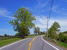 Route 416 passing horse farms after Thomas Bull Park
Leaving NY 207 in Hamptonburgh just past a tunnel under the tracks shared by Metro North and Norfolk Southern, it climbs a hill to pass the modest headquarters of Ottaway Community Newspapers, publishers of the local daily, the Times Herald-Record. A bit further on, it passes the Hill-Hold historic site on the east and provides the main access to Thomas Bull Memorial Park, one of the county's most popular.[3]
After the park it begins a descent to the lowlands around the Wallkill River, a stretch surrounded by picturesque horse farms. On a clear day the Shawangunks can be seen extending across the northwest horizon, and sometimes even the Catskills are visible beyond.[3]
It draws alongside the Wallkill as it and the highway cross under (but does not intersect) Interstate 84. It continues alongside the river and meanders past some more farmland for a mile as it enters the town of Montgomery. On the west side of the highway a parking area gives way to a recently restored slave cemetery. NY 416 reaches its northern terminus just south of the Montgomery village line at NY 211. This intersection is right next to Orange County Airport and two other historic sites. The Harrison Meeting House Site and Cemetery is on the east side of the road, and the Johannes Miller House just opposite on 211.[3]
History
NY 416 was assigned as part of the 1930 renumbering of state highways in New York.[1] Originally, NY 416 followed then-NY 84 northeast into Montgomery, where both routes terminated at NY 17K.[4] In the mid-1960s, the NY 84 designation was eliminated to avoid confusion with the new Interstate 84. The portion of its former alignment east of Middletown was replaced with an extended NY 211.[5][6] NY 416 was truncated to its current length by 1970.[7]
Major intersections
The entire route is in Orange County.
Location Mile[2] Destinations Notes Hamptonburgh 0.00 NY 207Town of Montgomery 4.24 NY 2111.000 mi = 1.609 km; 1.000 km = 0.621 mi References
- ^ a b Standard Oil Company of New York (1930). Road Map of New York (Map). Cartography by General Drafting.
- ^ a b "2008 Traffic Volume Report for New York State" (PDF). New York State Department of Transportation. June 16, 2009. p. 230. https://www.nysdot.gov/divisions/engineering/technical-services/hds-respository/NYSDOT%20TVR%202008%20by%20Route.pdf. Retrieved February 1, 2010.
- ^ a b c Google, Inc. Google Maps – overview map of NY 416 (Map). Cartography by Google, Inc. http://maps.google.com/maps?hl=en&rlz=1T4ADBF_enUS232US232&q=from:+RT-416+%4041.456791,+-74.276135+to:+RT-416+%4041.511393,+-74.252514&um=1&ie=UTF-8&sa=N&tab=wl. Retrieved January 4, 2008.
- ^ United States Geological Survey (1957). Walden Quadrangle – New York (Map). 1:24,000. 7.5 Minute Series (Topographic). http://www.nysgis.state.ny.us/gisdata/quads/drg24/usgspreview/index.cfm?code=o41074e2. Retrieved June 24, 2010.
- ^ Mobil (1965). New York (Map). Cartography by Rand McNally and Company.
- ^ Esso (1968). New York (Map). Cartography by General Drafting (1969–70 ed.).
- ^ State of New York Department of Transportation (January 1, 1970) (PDF). Official Description of Touring Routes in New York State. http://www.greaternyroads.info/pdfs/state70.pdf. Retrieved June 24, 2010.
External links
Categories:- State highways in New York
- Transportation in Orange County, New York
- Wallkill River


Wikimedia Foundation. 2010.