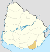
- Maldonado, Uruguay
-
Maldonado — Capital city — Location in Uruguay Coordinates: 34°54′0″S 54°57′0″W / 34.9°S 54.95°WCoordinates: 34°54′0″S 54°57′0″W / 34.9°S 54.95°W Country  Uruguay
Department Maldonado Department Founded 1754 Founder Joaquín de Viana Government - Mayor(Alcalde) Juan Carlos Bayeto (Broad Front) Population (2004) - Total 54,603 - Demonym Fernandino Time zone UTC -3 Postal code 20000 Area code(s) +598 42 Maldonado is the capital of Maldonado Department of Uruguay. It is located on Route 39 and shares borders with Punta del Este to the south, Pinares - Las Delicias to the south and to the east and suburb La Sonrisa to the north. Together they all for a unified metropolitan area. East of the city flows the stream Arroyo Maldonado. The next city to the north is San Carlos, only 13 kilometres (8.1 mi) away on Route 39.
Contents
History
Maldonado was founded in 1755 at the initiative of the Governor of Montevideo Joaquin de Viana. It was firmly established by the arrival of 104 permanent settlers in 1757. Its original name was Maldonado, but, years later, its name was changed to San Fernando de Maldonado, in honor of King Ferdinand VI of Spain.
Population
In 2004, it had a population of 54,603.[1]
Year Population 1963 15,372 1975 22,762 1985 33,535 1996 48,936 2004 54,603 Source: Instituto Nacional de Estadística de Uruguay[2]
Main sights
Remarkable sights in Maldonado include:
- San Fernando de Maldonado Cathedral, a neoclassic cathedral begun in 1801 and completed in 1895;
- Cuartel de Dragones (The Dragoons' Barracks), a Spanish garrison begun in 1771 and completed in 1797;
- Torre del Vigia (meaning "tower of vigilance" or, more simply, "watchtower"), built in 1800 under the direction of Rafael Pérez del Puerto, its function was to inform the authorities of the entrance in Buenos Aires of the approach of any ship to the Río de la Plata;
- El Puente de la Barra[3], a stressed ribbon bridge, where the roadbed swoops up, down, and back up and down once more, demonstrating an exceptional economy of material;
- Casapueblo hotel
Notes
- ^ "2004 Census of Maldonado department" (XLS). INE. 2004. http://www.ine.gub.uy/fase1new/Maldonado/Cuadro7_10.XLS. Retrieved 4 July 2011.
- ^ "1963–1996 Statistics / M" (DOC). Instituto Nacional de Estadística de Uruguay. 2004. http://www.ine.gub.uy/biblioteca/toponimico/TOPOletraM.doc. Retrieved 4 July 2011.
- ^ Puente de la Barra de Maldonado at Structurae. Retrieved on 2009-12-07. 34°54′39″S 54°52′22″W / 34.9109038°S 54.8727447°W
See also
External links
- Many pictures of Maldonado, Punta del Este, Punta Ballena, Casapueblo, José Ignacio, Piriápolis, La Barra, Sierra De Las Animas
- The Maldonado Portal
- INE map of Maldonado
 Maldonado Department of Uruguay
Capital: Maldonado Towns and
villagesAiguá • Balneario Buenos Aires • Barrio Hipódromo • Barrio Los Aromos • Cerro Pelado • El Tesoro • Garzón, Uruguay • Gerona • Gregorio Aznárez • Hipódromo • La Sonrisa • Maldonado • Pan De Azúcar • Pinares - Las Delicias • Piriápolis • Playa Grande • Punta Del Este • San Carlos • San Rafael - El Placer • Villa Delia

Sights Arboretum Lussich • Casapueblo • Cerro Pan de Azúcar • Monumento al Ahogado • Punta Ballena
Categories:- Uruguay geography stubs
- Populated places in the Maldonado Department
- Populated places established in 1755
Wikimedia Foundation. 2010.

