- Cerro Pelado
-
Not to be confused with Cerro Pelado, Rivera.
Cerro Pelado — Suburb of Maldonado — Location in Uruguay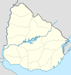
 Cerro Pelado
Coordinates: 34°53′0″S 54°59′0″W / 34.883333°S 54.983333°WCoordinates: 34°53′0″S 54°59′0″W / 34.883333°S 54.983333°W Country  Uruguay
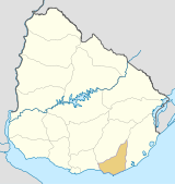
Department Maldonado Department Population (2004) – Total 6,385 Time zone UTC -3 Postal code 20000 Area code(s) +598 42 Cerro Pelado is a fast growing population centre in the Maldonado Department of southeastern Uruguay. It is one of the northern suburbs of Maldonado, along with Villa Delia and La Sonrisa.
Population
In 2004 it had a population of 6,385.[1]
Year Population 1985 130 1996 2.407 2004 6,385 Source: Instituto Nacional de Estadística de Uruguay[2]
References
- ^ "2004 Census of Maldonado department" (XLS). INE. 2004. http://www.ine.gub.uy/fase1new/Maldonado/Cuadro7_10.XLS. Retrieved 27 June 2011.
- ^ "1963–1996 Statistics / C" (DOC). Instituto Nacional de Estadística de Uruguay. 2004. http://www.ine.gub.uy/biblioteca/toponimico/TOPOletraC.doc. Retrieved 27 June 2011.
External links
 Maldonado Department of UruguayCapital: Maldonado
Towns and
villagesAiguá • Balneario Buenos Aires • Barrio Hipódromo • Barrio Los Aromos • Cerro Pelado • El Tesoro • Garzón, Uruguay • Gerona • Gregorio Aznárez • Hipódromo • La Sonrisa • Maldonado • Pan De Azúcar • Pinares - Las Delicias • Piriápolis • Playa Grande • Punta Del Este • San Carlos • San Rafael - El Placer • Villa Delia
Sights Arboretum Lussich • Casapueblo • Cerro Pan de Azúcar • Monumento al Ahogado • Punta Ballena
Categories:- Uruguay geography stubs
- Populated places in the Maldonado Department


Wikimedia Foundation. 2010.