- Indiana State Road 70
Infobox road
state=IN
type=IN
route=70
alternate_name=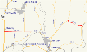
length_mi=
length_round=
length_ref=
established=
direction_a=
starting_terminus=
direction_b=
ending_terminus=
counties=
previous_type=IN
previous_route=69
next_type=IN
next_route=71State Road 70 in the
U.S. state ofIndiana consists of two discontinuous east-west segments of two-lane rural roadway. State Road 70 passes through no cities or towns of significant size.Western segment
The western segment is about convert|10|mi|km long and is relatively straight; it runs entirely within the boundaries of Spencer County, from
U.S. Route 231 at the west end through the unincorporated town of Newtonville to State Road 66 at the east end.Major intersections
Source: INDOT Roadway Referencing Systemcite web|url=http://www.in.gov/indot/3361.htm|title=INDOT Roadway Referencing System] INint
county=Spencer
cspan=3
mile=0.00
road=
location=Spencer County
lspan=3INint
mile=7.18
road=INint
mile=9.75
road=Eastern segment
The eastern segment about convert|6.2|mi|km long and is a more winding road than the western segment; it runs entirely within Perry County, from State Road 37 at the west end to State Road 66 in the community of Derby, on the banks of the
Ohio River , at the east end.Major intersections
Source: INDOT Roadway Referencing SystemINint
county=Perry
cspan=2
mile=9.75
road=
location=Perry County
lspan=2INint
mile=15.92
road=References
External links
* [http://illi-indi.com/EndsPage.php?id=1070§ion=1 Indiana Highway Ends - SR 70]

Wikimedia Foundation. 2010.