- Indiana State Road 69
Infobox road
state=IN
type=IN
route=69
alternate_name=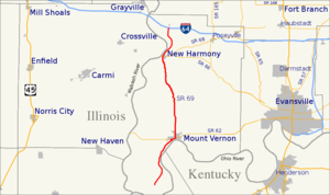
length_mi=22.8
length_round=1
length_ref= [http://illi-indi.com/EndsPage.php?id=1069§ion=1 Indiana Highway Ends - SR 69] ]
established=
direction_a=South
starting_terminus=Hovey Lake Fish and Wildlife Area
direction_b=North
ending_terminus=
counties=Posey
previous_type=IN
previous_route=68
next_type=IN
next_route=70State Road 69 in the
U.S. state ofIndiana cuts north-south through western Posey County. Originally, the highway was between New Harmony and Mount Vernon. Eventually SR 69 was connected to Interstate 64 at the Griffin exit and rerouted to bypass New Harmony. In Mount Vernon, SR 69 was extended all the way down to Hovey Lake State Fish and Wildlife Area. In the late 1990s, SR 69 was routed onto the new William Keck Bypass on the eastern side of Mount Vernon.Because of its status as a connector between
Southwind Maritime Centre andInterstate 64 , State Road 69 has exceptionally wide shoulders throughout much of its route, especially in the section north of Mt. Vernon.From south to north, the highway serves the towns of Mount Vernon, Farmersville, Solitude, New Harmony, and Griffin.
Major Intersections
Source: INDOT Roadway Referencing System [cite web|url=http://www.in.gov/indot/3361.htm|title=INDOT Roadway Referencing System]
INint
county=Posey
cspan=8
location=Posey County
lspan=2
mile=0.00
notes=Southern terminus of SR 69 atHovey Lake Fish and Wildlife Area .INint
type=concur
mile=8.21
road=
notes=Western terminus of concurrence with SR 62.INint
location=Mt. Vernon
type=concur
mile=13.48
road=
notes=Eastern terminus of concurrence with SR 62.INint
location=Posey County
road=
mile=25.91
notes=Spur toHarmonie State Park .INint
location=New Harmony
type=concur
mile=28.81
road=
notes=Western terminus of concurrence with SR 66.INint
location=Posey County
lspan=2
type=concur
mile=29.67
road=
notes=Eastern terminus of concurrence with SR 66.INint
road=
mile=30.48
notes=Western terminus of SR 68.INint
location=Griffin
road=
mile=35.07
notes=Northern terminus of SR 69.References

Wikimedia Foundation. 2010.