Karapınar

Karapınar

Infobox Settlement
settlement_type = District
subdivision_type = Country
subdivision_name = TUR
timezone= EET
utc_offset=+2


map_caption =Location of PAGENAME within Turkey.
timezone_DST=EEST
utc_offset_DST=+3
official_name = Karapınar


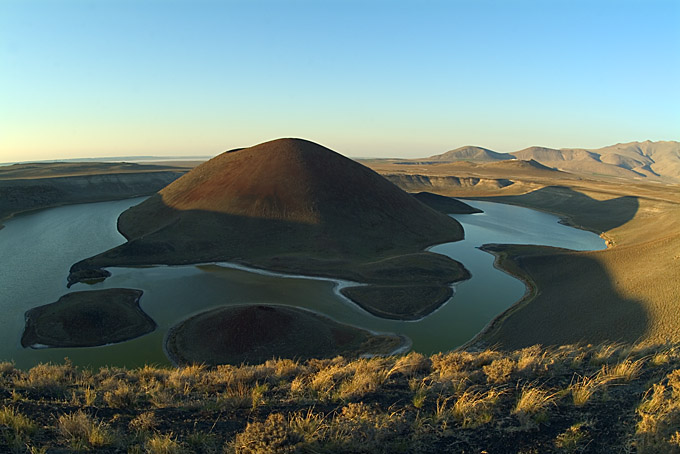
image_caption = Meke Dağı, a volcanic field in Karapınar
image_blank_emblem =
blank_emblem_type =
map c
Turkey
subdivision_type2=Province
subdivision_name2 = Konya
population_total = 55734
population_urban = 35285
population_as_of = 2000
population_footnotes =
population_density_km2 =
area_total_km2 =
latd = 37
latm = 43
latNS = N
longd = 33
longm = 33
longEW = E
elevation_m = 987
postal_code_type=Postal code
postal_code = 42xxx
area_code = 0332
blank_info = 42
blank_name=Licence plate
leader_title=
leader_name =
website = [http://www.karapinar.gov.tr/ www.karapinar.gov.tr]

Karapınar is a town and district of Konya Province in the Central Anatolia region of Turkey. According to 2000 census, population of the district is 55,734 of which 35,285 live in the town of Karapınar.cite web|url=http://www.die.gov.tr/nufus_sayimi/2000tablo5.xls|title=Census 2000, Key statistics for urban areas of Turkey|accessdate=2008-03-24|author=Turkish Statistical Institute|format=XLS|language=Turkish] [cite web|url=http://www.xist.org/cntry/turkey.aspx?levels=Ic%20Anadolu|title=Statistical information on Turkey's administrative units|accessdate=2008-03-24|author=GeoHive|language=English] Volcanic Karapınar Field is located nearby.

Notes

References

*

External links

* [http://www.karapinar.gov.tr/ District governor's official website] tr icon
* [http://www.karapinar.bel.tr/ District municipality's official website] tr icon


Wikimedia Foundation. 2010.

Игры ⚽ Поможем написать реферат

Look at other dictionaries:

  • Karapınar — Administration Pays …   Wikipédia en Français

  • Karapinar — or Macarköy (Hungarian: Feketeforrás or Magyarfalu(Madzsarköj)) is a Hungarian village in Turkey, at the Aegean shore. Karapinar is the new name of the village.HistoryThis village was established 420 years ago. The villagers came here when part… …   Wikipedia

  • Karapinar — Original name in latin Karapnar Name in other language Karapinar, Karapnar, Sultaniye State code TR Continent/City Europe/Istanbul longitude 37.71596 latitude 33.55064 altitude 995 Population 49509 Date 2012 01 18 …   Cities with a population over 1000 database

  • Karapınar (Malatya) — Karapınar is a village of Hekimhan district in Malatya Province, Turkey.HistoryThe word of Karapınar connotes as Black Spring Water . Village s name stems from the village s main spring water. Although this village was established more than 400… …   Wikipedia

  • Karapınar Field — Infobox Mountain Name=Karapınar Photo=Karapinar Field NASA.jpg Caption=Karapınar Field seen from space (false color) Elevation=1,302 metres (4,272 feet) Location=Konya Province, Turkey Range= Prominence = Coordinates =… …   Wikipedia

  • Karapınar — is., öz. Konya iline bağlı ilçelerden biri …   Çağatay Osmanlı Sözlük

  • İncirliova — Infobox Settlement settlement type = Town subdivision type = Country subdivision name = TUR timezone=EET utc offset=+2 map caption =Location of PAGENAME within Turkey. timezone DST=EEST utc offset DST=+3official name = İncirliova image caption =… …   Wikipedia

  • Konyaspor — Voller Name Konyaspor Kulübü Gegründet 26. Mai 1981 Vereinsfarben …   Deutsch Wikipedia

  • Jandarma İstihbarat ve Terörle Mücadele — (abbr. JİTEM , in en. Gendarmerie Intelligence and Counterterrorism) is a wing of the Turkish Gendarmerie, active in the Turkey PKK conflict. [cite news|url=http://turkishdailynews.com.tr/archives.php?id=1902 accessdate=2008 10 09 title=PKK… …   Wikipedia

  • Bagdad-Bahn — Bagdadbahn Streckenlänge: 1597 km Spurweite: 1435 mm (Normalspur) Konya–Bagdad Legende …   Deutsch Wikipedia

Share the article and excerpts

Direct link
Do a right-click on the link above
and select “Copy Link”