- Chatelherault railway station
-
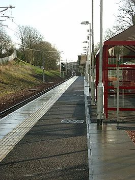
Chatelherault 
Location Place Ferniegair Local authority South Lanarkshire Operations Station code CTE Managed by First ScotRail Number of platforms 1 Live arrivals/departures and station information
from National Rail EnquiriesAnnual rail passenger usage 2005/06 * 3,763 2006/07 * 17,268 2007/08 * 23,480 2008/09 * 40,962 Passenger Transport Executive PTE SPT History Pre-grouping Caledonian Railway 1 December 1866 Opened as Ferniegair, as a terminus 2 October 1876 Re-located as a through station 1 January 1917 Closed 9 December 2005 Re-opened National Rail - UK railway stations A B C D E F G H I J K L M N O P Q R S T U V W X Y Z * Annual passenger usage based on sales of tickets in stated financial year(s) which end or originate at Chatelherault from Office of Rail Regulation statistics. Please note: methodology may vary year on year. Chatelherault railway station serves the village of Ferniegair on the outskirts of Hamilton, South Lanarkshire. It is named Chatelherault after the nearby Chatelherault Country Park.
Contents
History
The station was opened as Ferniegair on 1 December 1866 as a terminus for trains approaching from the south on the Caledonian Railway's Coalburn Branch. Passengers for Glasgow had to transfer to Hamilton by coach. It was re-built and re-located as a through station on 2 October 1876, with trains continuing to Motherwell railway station on the Clydesdale Junction Railway. The Caledonian Railway closed the station on 1 January 1917.
Re-opening
The station is on the Argyle Line, and was officially re-opened on the 9 December 2005 by First Minister Jack McConnell as part of the extension of the Argyle Line to include Larkhall.
Services
From the re-opening in December 2005, trains ran on Mondays and Saturdays every 30 minutes north west to Dalmuir via Singer and south to Larkhall. A trial (for one year) Sunday service commenced from December 2007 with an hourly service in each direction, and due to high uptake was made permanent in December 2008.
External links
- Train times and station information for Chatelherault railway station from National Rail
- New Link for Larkhall opens - BBC News Scotland website
- RAILSCOT on Larkhall re-opening
- RAILSCOT on Coalburn Branch
- RAILSCOT on Mid Lanark Lines
Preceding station  National Rail
Following station Merryton First ScotRail
Hamilton Central Historical railways Larkhall Central
Line and station openMid Lanark Lines
Motherwell
Line and station open
(except section between
Chatelherault and Ross Junction)Larkhall East
Line partially open;
station closedCoalburn Branch
Coordinates: 55°45′54″N 4°00′18″W / 55.765°N 4.005°W
Categories:- Railway stations in South Lanarkshire
- Former Caledonian Railway stations
- Railway stations opened in 1866
- Railway stations closed in 1876
- Railway stations opened in 1876
- Railway stations closed in 1917
- Railway stations opened in 2005
- SPT railway stations
- Railway stations served by First ScotRail
- Hamilton, South Lanarkshire
- Scotland railway station stubs

Wikimedia Foundation. 2010.