- Wattle Grove, Western Australia
Infobox Australian Place | type = suburb
name = Wattle Grove
city = Perth
state = wa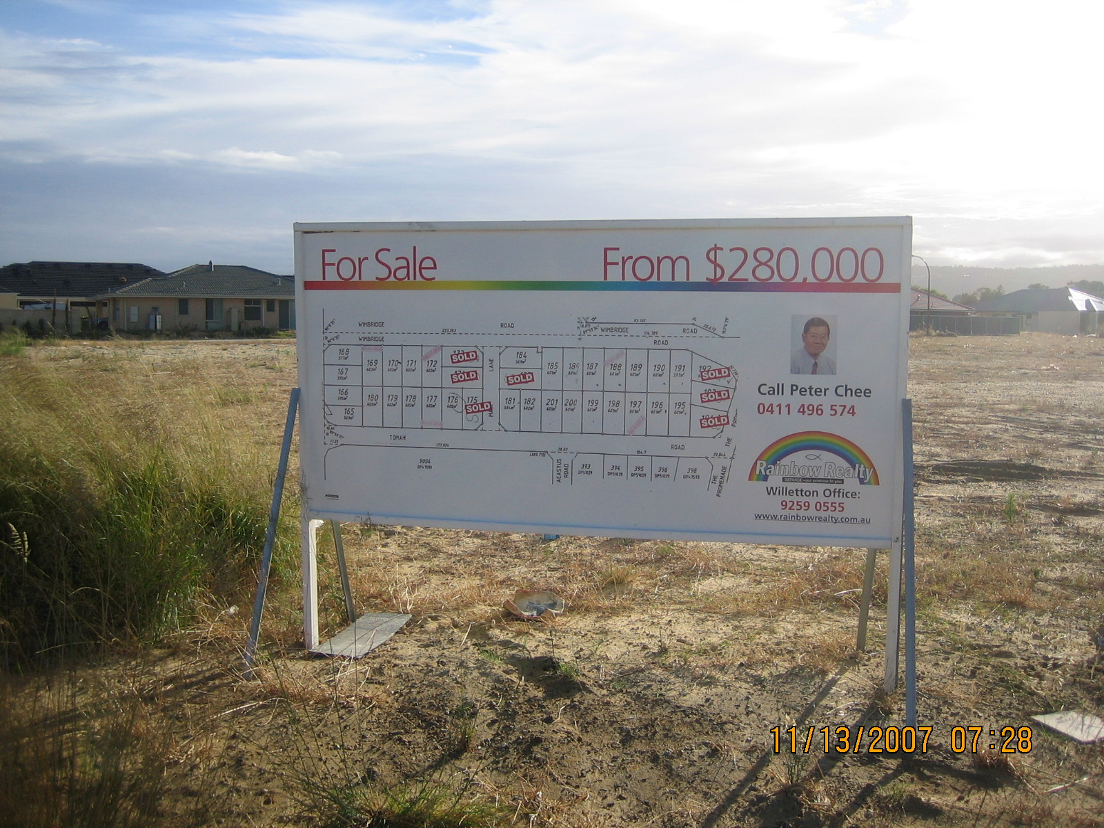
caption = Land for sale signs in cell 9 as land is sub divided by developers in Wattle Grove
lga = Shire of Kalamunda
area =
postcode = 6107
pop = 2,339 (2006)
pop_footnotes= Census 2006 AUS|id=SSC52481|name=Wattle Grove (State Suburb)|accessdate=2008-10-02|quick=on]
dist1 = 13 | dir1 = E
location1 =Perth, Western Australia
est=
fedgov=Hasluck
stategov=Forrestfield
stategov2=Kalamunda
near-e =Forrestfield
near-se =Lesmurdie
near-sw=Orange Grove
near-s =Kenwick
near-n=Welshpool
near-ne=Perth Airport
near-w =Beckenham
near-nw=East Canningtoncoord|-32.008|116.014|type:city(2339)_region:AU-WA_scale:50000|format=dms|display=titleWattle Grove is a suburb of
Perth, Western Australia , located within theShire of Kalamunda .Description
Wattle Grove is approximately 3/4 Semi Rural, and 1/4 Urban Development. It contains some of
Hartfield Park , and extends from Crystal Brook Rd to Roe Hwy. Major Transport Routes through the suburb are Welshpool Rd, Hale Rd, Tonkin Hwy and Roe Hwys.Public Transport
Bus routes are
* 287 to and from the city viaHartfield Park stop on Hale Rd,
* 288 to and from the city viaHartfield Park stop on Hale Rd,
* 787 to and from the city viaHartfield Park stop on Hale Rd,
* 788 to and from the city viaHartfield Park stop on Hale Rd,
* 294 to Midland Train Station or to Cannington Train Station via Hale Rd,
* 282 to and from Lesmuirdie and the city via Welshpool Rd.
* 283 to and from Kalamunda and the city via Crystal Brook Rd.The nearest Train stations are
* Kenwick Train Station on the Armadale Line,
* Beckenham Train Station on the Armadale Line,
* Cannington Train Station on the Armadale Line,Facilities
Playgrounds are located throughout the new subdivisions in the suburb, as well as walking and bike paths leading to newly created artificial lakes.
Wattle Grove is served by Wattle Grove Primary School, and a Community TAFE Centre in Lewis Rd and the Bible College of Western Australia (Private) [ [http://www.bcwa.wa.edu.au/ Bible College of Western Australia] ] . A second primary school is to be built on the area bordered by St John Rd, Tomah Rd, and Acastus Rd.
Hartfield Recreation Centre, located nearby, provides gymnasium facilities [ [http://www.kalamunda.wa.gov.au/Service+We+Provide/Sports+And+Recreation/Hartfield+Park+Rec+Centre/Default.htm Hartfield Park Rec Centre] ] as well as opportunities for playing Rugby League, Soccer, Baseball, Cricket, Tennis. Hartfield Park also contains the Darling Range Horse and Pony Club [ [http://www.efawa.com.au/db/ClubDisplay.asp?ID=790&Action=Display Darling Range Horse and Pony Club] ] , the Hartfield Country Club (Golf Course) [ [http://www.hartfieldgolf.com.au/welcome/index.mhtml Hartfield Country Club] ] , Boy Scouts, and Car Club rooms.
Wattle Grove is well connected to other regions of Perth due to its proximity to the
Roe Highway andTonkin Highway .The most direct route to the Perth CBD is via Welshpool /Shepperton Road s (12 km all in 60 km/h zones), however alternative routes are available viaOrrong Road /Graham Farmer Freeway (14 km in 70 & 80 km/h zones),Tonkin Highway /Guildford Road (18 km in 100 & 60 km/h zones), andRoe Highway /Kwinana Freeway (23 km all in 100 km/h zone and the only route without traffic lights).Wattle Grove has no major retail facilities within its boundaries, has two vets, a motel, a number of nurseries, landscape suppliers, agistment paddocks, boarding kennels and a Bird / Fish & Reptile shop. [ [http://www.campwattlegrove.com.au/ Camp Wattle Grove] ] [ [http://www.wattlegrovemotel.com.au/ Wattle Grove Motel] ] [ [http://www.grasstrees.com.au/ Grasstrees at Wattle Grove] ] [ [http://lovegroveturf.com/ Lovegrove Turf Farm at Wattle Grove] ] [ [http://www.soiland.com.au/ Soiland HQ at Wattle Grove] ] [ [http://www.treesagreen.com/ Trees a green at Wattle Grove] ]
The nearest Police Station is at Forrestfield,and Public Hospitals are available at Bentley and Kalamunda. [WA Police] [List of Hospitals in Western Australia]
History
Wattle Grove was once all agricultural farm land containing Poultry farms, Equestrian Studs, Agistment paddocks, Horticultural Nurseries, Pet Kennels, Hobby farms and Cattle Breeders.
Recent Events
After a concerted campaign was lost during the 1980s by the Save our Foothills action group a quarter of the suburb bounded by Welshpool Road,
Tonkin Highway andRoe Highway has been rezoned as Urban Development by theShire of Kalamunda and is known as cell 9 () in the shire plan. This area of Wattle Grove is now a hive of activity as land is subdivided and houses built. The price of land in cell 9 has subsequently risen exponentially since the first sub division in 1999.Demographics & Politics
Wattle Grove has a broadly middle-class, Owner occupier, Anglo-Australian population and supports the
Australian Liberal Party at both Federal and state elections. [http://results.aec.gov.au/12246/results/HouseDivisionFirstPrefs-12246-305.htm Australian Electoral Commission results for 2004 Federal Election] In the 2004 election the Wattle Grove Booth recorded over 60% support for the Liberal Party.http://psephos.adam-carr.net/countries/a/australia/2007maps/hasluckbig.shtml booth by booth 2004 Federal Election Result [http://psephos.adam-carr.net/countries/a/australia/2007seats/hasluck.shtml Adam Carr's guide to the 2007 Federal Election] In the 2007 Federal Election the Wattle Grove booth recorded just over 58% support for the Liberal Party - A swing of over 6% to the Labor Party, but still a safe Liberal polling booth. [http://results.aec.gov.au/13745/website/HouseDivisionTcpByPollingPlace-13745-305.htm 2007 Hasluck election results (booth by booth)]References
Wikimedia Foundation. 2010.