- Sava Banovina
Infobox Former Subdivision
native_name = Savska banovina
conventional_long_name = Sava Banovina
common_name = Sava Banovina
subdivision = Banovina
nation =Kingdom of Yugoslavia
p1 = Zagreb Oblast
p2 = Osijek Oblast
p3 = Novi Sad Oblast
s1 = Banovina of Croatia
event_start = Royal dictatorship
year_start = 1929
event_end =Cvetković-Maček Agreement
year_end = 1939
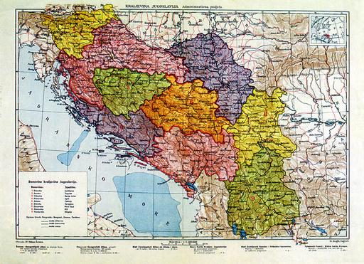
image_map_caption = Sava Banovina (in pink, at top) within the Kingdom of Yugoslavia
capital =Zagreb
stat_area1 =
stat_pop1 =
stat_year1 =
today =
footnotes = The Sava Banovina or Sava Banate (Croatian: "Savska banovina") was a province (banovina) of theKingdom of Yugoslavia between 1929 and 1939. This province consisted of much of present-dayCroatia (the areas of historical Croatia andSlavonia ) and was named for theSava River. The capital city of the Sava Banovina wasZagreb .Borders
According to the 1931
Constitution of the Kingdom of Yugoslavia, :"The Sava Banovina is bounded on the north, as far as the riverMura , by the ... boundary of theDrava Banovina . Thereafter the boundary of this Banovina follows the river Mura, then the State frontier withHungary to the point where this leaves the Drava; from this point the boundary of the Banovina follows the course of the Drava, then that of theDanube , as far as the northern boundary of the district ofIlok . From this point the boundary of the Banovina leaves the Danube and goes towards the Sava, following the eastern boundaries of the district, ofVukovar ,Vinkovci , andŽupanja ; taking in these districts. It then follows the course of the river Sava to the mouth of the river Una, then the course of the river Una as far as the north-eastern boundary of the district ofDvor (south-west of Kostajnica). From this point to the Adriatic (Morlach Channel) the boundary of the Banovina follows the southern boundaries of the districts of Kostajnica,Petrinja , Glina, and Virginmost (Gvozd), then the south-eastern boundary of the district ofVojnić and the eastern boundaries of the districts ofSlunj ,Korenica andDonji Lapac . The boundary then passes along the southern boundary of the districts ofGračac andGospić , which it includes. From the Adriatic coast the boundary follows the gorge ofLjubač and the canal of NovaPovljana , passes between the islands of Maun andPlanik , to rejoin, north of the islands ofOlib andSilba , the State frontier on the Adriatic."History
In 1939, the Sava Banovina was merged with the
Littoral Banovina and parts of neighboring provinces to create theBanovina of Croatia .In 1941, the
World War II Axis Powers occupied the former area of the Sava Banovina. Small areas were annexed by Fascist Italy andHungary with the remainder becoming a part of theIndependent State of Croatia . Following World War II, the region was made a part ofCroatia within a federal Communist Yugoslavia.References
* [http://www.geocities.com/dagtho/yugconst19310903.html The Constitution of the Kingdom of Yugoslavia]
ee also
*
Kingdom of Yugoslavia External links
* [http://terkepek.adatbank.transindex.ro/kepek/netre/178.gifMap]
Wikimedia Foundation. 2010.
