- Desolation Sound
-
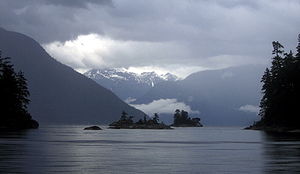
Desolation Sound is a deep water sound in British Columbia, Canada. It is a favourite destination for boaters because of its spectacular fjords, mountains, and wildlife. It is part of the Sunshine Coast.
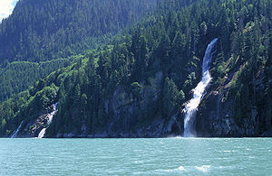
The sound is home to the steepest drop from mountain peak to sea bottom in all of North America.[citation needed] It has many waterfalls cascading into milky green glacial runoff. The geology of the coast is dominated by igneous (mainly granitic) shorelines. These fjords are the result of intense glaciation of the mountainous coastline.
Contents
Desolation Sound Marine Provincial Park
The Government of Canada created Desolation Sound Provincial Marine Park in 1973 out of an area comprising 8449 hectares and over 60km of shoreline.[1] The natural shelter provided by the parks many inlets, islets, coves and bays make it an ideal location to explore by pleasure craft. [1]. The area is home to a wide variety of wildlife, and is still relatively free from development, unfortunately some areas do show signs of clear cut logging such as Theodesia Inlet. [2] The park is extremely popular in the summer months (June-August) as many hundreds of boaters flock to this region; it is not uncommon for a hundred boats to share a small anchorage. [2]
Major Anchorages and Inlets
Prideaux Haven, Grace Harbour, Tenedos Bay, Bute Inlet, Toba Inlet
History
The sound was inhabited by tribes of the Mainland Comox prior to the arrival of Europeans, who first charted the sound in 1792. Two expeditions led by Captains George Vancouver, Dionisio Alcalá Galiano and Cayetano Valdés y Flores arrived that same summer and cooperated in mapping the sound. Vancouver named it Desolation Sound saying "there was not a single prospect that was pleasing to the eye". [3]
Throughout the nineteenth century various European traders continued to visit the area, primarily from the Hudson's Bay Company. In the late 19th century white settlement increased dramatically in the area after a rapid drop in the native population levels following smallpox and tuberculosis outbreaks. The shelter of the sound provided a good foundation for the fishing and logging industries primarily. A large mill was established at Powell River.
Coordinates: 50°00′00″N 124°52′30″W / 50.000°N 124.875°W
References
- ^ A Dreamspeaker Cruising Guide, Volume 2, Second Edition, Anne & Laurence Yeadon-Jones, 2006
- ^ a b Exploring the South Coast of British Columbia, Third Edition, Don Douglass & Reanne Hemingway-Douglass, 2009
- ^ [|Robson, Robson] (2007). "Hakluyt edition of Vancouver's journals". W. Kaye Lamb, editor, Vol. 2, p 609. http://pages.quicksilver.net.nz/jcr/~vancouver5.html. Retrieved 2007-07-27.
External links
Categories:- Central Coast of British Columbia
- Sounds of British Columbia
Wikimedia Foundation. 2010.


