Mariveles Mountains

Mariveles Mountains
Mariveles Mountains

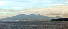
Mariveles Mountains as seen from Manila Bay
Elevation 1,388 m (4,554 ft)
Location
Location Mariveles, Bataan, Luzon, Philippines
Range Mariveles Mountains
Coordinates 14°30′N 120°30′E / 14.5°N 120.5°E / 14.5; 120.5Coordinates: 14°30′N 120°30′E / 14.5°N 120.5°E / 14.5; 120.5
Geology
Type Volcanic
Volcanic arc/belt Western Luzon Volcanic Arc

The Bundok ng Mariveles[pronunciation?] are located on the Bataan Peninsula in the Philippines. The highest peak, Mount Mariveles, is an andesitic stratovolcano reaching 1388 meters asl.

There are already 3 peaks familiar to the local mountaineering community namely: Tarak Ridge, Banayan or Pantingan Peak and Mariveles Ridge. The rest are still waiting to be explored.

Tarak Ridge is the well known destination at Mt. Mariveles with its jump-off point situated at Barangay Alas-asin, Mariveles, Bataan.

Pantingan Peak (locals call it Banayan Peak) can be accessed through Sitio Duhat, Saysain, Bagac, Bataan.

Mariveles bridge can be accessed through Sitio Parca, Mariveles, Bataan.

External links

See also


Wikimedia Foundation. 2010.

Игры ⚽ Нужно решить контрольную?

Look at other dictionaries:

  • Mariveles, Bataan — Mariveles   Municipality   Mariveles as seen from Manila Bay …   Wikipedia

  • Mariveles — may refer to: Mariveles, Bataan (municipality) Mariveles Mountains This disambiguation page lists articles associated with the same title. If an internal link led you here, you may wish to change the link to po …   Wikipedia

  • Mount Mariveles — as seen from Manila Bay Elevation 1,388 m (4,554 ft) …   Wikipedia

  • Zambales Mountains — ▪ mountains, Philippines       volcanic range in the southwestern part of northern Luzon in the Philippines. The range stretches northwest southeast from Lingayen Gulf in the north to the Bataan Peninsula and the entrance to Manila Bay in the… …   Universalium

  • Bataan — Infobox Philippine province name = Bataan sealfile = Ph seal bataan.png region = Central Luzon (Region III) capital = Balanga City founded = 1754 pop2000 = 557,659 pop2000rank = 46th largest popden2000 = 406 popden2000rank = 12th highest areakm2 …   Wikipedia

  • Bataan Peninsula — The Bataan Peninsula is a rocky extension of the Zambales Mountains, on Luzon in the Philippines. It separates the Manila Bay from the South China Sea. The peninsula features Mount Natib (1,253 m) in the north and the Mariveles Mountains in the… …   Wikipedia

  • Péninsule de Bataan — 14°35′N 120°28′E / 14.583, 120.467 …   Wikipédia en Français

  • Battle of Bataan (1945) — Infobox Military Conflict conflict=Battle for the Recapture of Bataan caption= partof=World War II, Pacific theater date=31 January – 8 February 1945 place=Bataan Peninsula, Philippines result=Allied victory combatant1=flagicon|United States|1912 …   Wikipedia

  • Diego Fajardo Chacón — was a Spanish military officer and governor of the Philippines, from August 11, 1644 to July 25, 1653. Contents 1 Background 2 Arrival in the Philippines 3 Domination by Eustacio de Venegas 4 …   Wikipedia

  • Bataan Peninsula — ▪ peninsula, Philippines       peninsula in central Luzon, Philippines, sheltering Manila Bay (east) from the South China Sea. It is about 30 miles (50 km) long and 15 miles (25 km) wide. Corregidor Island lies just off its southern tip at the… …   Universalium

Share the article and excerpts

Direct link
Do a right-click on the link above
and select “Copy Link”