- Georgia State Route 6
Infobox road
state=GA
type=
route=6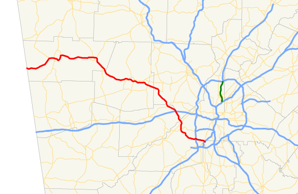
length_mi=72
length_ref= [http://www.dot.state.ga.us/DOT/plan-prog/transportation_data/400reports/2002/dpp444_2002.pdf]
length_round=0
established=
direction_a=West
direction_b=East
starting_terminus=Alabama state line, southwest of Cedartown
junction=
ending_terminus=
previous_route=5
next_route=7State Route 6 (also known as
Tuskegee Airmen Parkway in Fulton County, Thornton Road in Douglas County, C.H. James Parkway in Cobb County and Jimmy Lee Smith Parkway and Wendy Bagwell Parkway in Paulding County) begins at the Georgia-Alabama state line southwest of Cedartown in Esom Hill and ends at I-85, exit 72, in College Park. State Route 6 is the state designation forU.S. 278 from the Alabama border toU.S. 78 in Douglas County. The eastern end of Tuskegee Airmen Parkway (S.R. 6) carries traffic to Interstate 85 North/South and the Atlanta Airport.Recently, at the intersection of Tuskegee Airmen Parkway (S.R. 6) and I-285 in East Point, there has been a renaissance for south Fulton County: the opening of the
Camp Creek MarketPlace . It was opened in late 2003, and the second portion is scheduled to open in spring or summer of 2006. It rivals evenLenox Square in size.On August 1st, 2008, the City of Atlanta, officially renamed Camp Creek Parkway (The 12-mile stretch of GA 6, between Fulton Industrial Boulevard and Interstate 85), in honor of the Tuskegee Airmen.
Wikimedia Foundation. 2010.