- Nossen
-
Nossen 
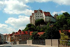
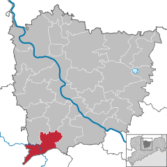
Coordinates 51°03′N 13°18′E / 51.05°N 13.3°ECoordinates: 51°03′N 13°18′E / 51.05°N 13.3°E Administration Country Germany State Saxony Admin. region Dresden District Meißen Mayor Uwe Anke Basic statistics Area 50.50 km2 (19.50 sq mi) Elevation 259 m (850 ft) Population 7,162 (31 December 2010)[1] - Density 142 /km2 (367 /sq mi) Other information Time zone CET/CEST (UTC+1/+2) Licence plate MEI Postal codes 01681–01683, 8255 Area code 035242 Website www.nossen.de Nossen is a town in the district of Meißen, in the Free State of Saxony, Germany. It is part of the Dresden region, and located 80 km southeast of Leipzig. The town is dominated by a large Renaissance castle.
History
During World War II, a subcamp of Flossenburg concentration camp was located here.[2]
References
- ^ "Bevölkerung des Freistaates Sachsen jeweils am Monatsende ausgewählter Berichtsmonate nach Gemeinden" (in German). Statistisches Landesamt des Freistaates Sachsen. 31 December 2010. http://www.statistik.sachsen.de/download/010_GB-Bev/Bev_Gemeinde.pdf.
- ^ Christine O'Keefe.Concentration Camps.ww.tartanplace.com/tartanhistory/concentrationcamps.html
External links
- Official site (German)
Coswig | Diera-Zehren | Ebersbach | Glaubitz | Gröditz | Großenhain | Hirschstein | Käbschütztal | Ketzerbachtal | Klipphausen | Lampertswalde | Leuben-Schleinitz | Lommatzsch | Meissen | Moritzburg | Nauwalde | Niederau | Nossen | Nünchritz | Priestewitz | Radebeul | Radeburg | Riesa | Röderaue | Schönfeld | Stauchitz | Strehla | Tauscha | Thiendorf | Triebischtal | Weinböhla | Weißig am Raschütz | Wülknitz | ZeithainCategories:- Towns in Saxony
- Meißen District
- Saxony geography stubs
Wikimedia Foundation. 2010.


