- Pătârlagele
Infobox Settlement
subdivision_type = Country
subdivision_name = ROU
timezone=EET
utc_offset=+2
timezone_DST=EEST
utc_offset_DST=+3
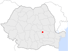
map_caption = Location of Pătârlagele|official_name=Pătârlagele
subdivision_type1=County
subdivision_name1=Buzău County
subdivision_type2=Status
subdivision_name2=Autolink|Town
settlement_type=Town|
leader_title=Mayor
leader_name=Valeriu Sârbu
leader_party=Social Democratic Party
|area_total_km2=80.45
population_as_of=2002
population_total=8226|latd=45|latm=19|lats=8|latNS=N|longd=26|longm=21|longs=35|longEW=E|
website=Pătârlagele (also spelled: "Pătîrlagele"; IPA2|/pə.tɨr'la.dʒe.le/) is a town in the
Buzău County ,Romania . It has a population of 8,414.Geography
Pătârlagele is located in the western part of the county, along the national road connecting
Buzău andBraşov , in the Pătârlagele hollow, between theCarpathian Mountains and the Subcarpathian Hills.Neighbours
* The
Colţi andBozioru communes, to the north
* ThePănătău andCozieni communes, to the east
* TheCislău commune, to the south
* TheCătina ,Calvini andChiojdu communes, to the westHistory
The first evidence of the existence of the Pătârlagele commune date back from 1524-1527 [http://www.cdep.ro/proiecte/2004/000/80/8/em088.pdf] , but it probably existed before the establishment of the medieval state of
Wallachia .The name "Pătârlagele" comes from the German form of the name "Peter" (in Romanian, "Petre" or "Petru"), and the German word "lager", meaning "camp". The German origin of the name can only be explained by the presence of the
Teutonic knights on the other side of the Carpathians, inŢara Bârsei , during the years1211 -1225 and their conquest of the Buzău Mountains, where they raised fortifications against theCumans .The Pătârlagele commune received town rights in 2004. [http://www.cdep.ro/proiecte/2004/000/80/8/doc088.pdf]
Wikimedia Foundation. 2010.