- Mane, Alpes-de-Haute-Provence
-
Mane


 Mane
ManeAdministration Country France Region Provence-Alpes-Côte d'Azur Department Alpes-de-Haute-Provence Arrondissement Forcalquier Canton Forcalquier Intercommunality Haute Provence Mayor Jacques Depieds
(2008–2014)Statistics Elevation 386–868 m (1,266–2,848 ft)
(avg. 500 m/1,600 ft)Land area1 22 km2 (8.5 sq mi) Population2 1,355 (2008) - Density 62 /km2 (160 /sq mi) INSEE/Postal code 04111/ 04300 1 French Land Register data, which excludes lakes, ponds, glaciers > 1 km² (0.386 sq mi or 247 acres) and river estuaries. 2 Population without double counting: residents of multiple communes (e.g., students and military personnel) only counted once. Coordinates: 43°56′21″N 5°46′06″E / 43.9391666667°N 5.76833333333°E
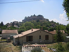
Mane (Mana in Occitan) is a commune in Alpes-de-Haute-Provence department in southeastern France.
It lies near Forcalquier. It was the birthplace of Louis Feuillée. A Minim convent was situated here. The ancient Pont sur Laye is close by the town.
Population
Historical population of Mane, Alpes-de-Haute-Provence 1765 1793 1800 1806 1821 1831 1836 1841 1846 1851 1281 1357 1324 1408 1461 1542 1507 1495 1583 1521 1856 1861 1866 1872 1876 1881 1886 1891 1896 1901 1522 1528 1446 1430 1335 1333 1430 1174 1099 1066 1906 1911 1921 1926 1931 1936 1946 1954 1962 1968 1012 987 990 830 744 775 690 674 703 852 1975 1982 1990 1999 2008 834 943 1135 1169 1355 See also
References
Categories:- Communes of Alpes-de-Haute-Provence
- Alpes-de-Haute-Provence geography stubs


Wikimedia Foundation. 2010.