Morton-on-Swale

Morton-on-Swale

Coordinates: 54°19′19″N 1°30′11″W / 54.32181°N 1.50314°W / 54.32181; -1.50314

Morton-on-Swale
Morton-on-Swale is located in North Yorkshire
Morton-on-Swale

 Morton-on-Swale shown within North Yorkshire
OS grid reference SE324919
District Hambleton
Shire county North Yorkshire
Region Yorkshire and the Humber
Country England
Sovereign state United Kingdom
Police North Yorkshire
Fire North Yorkshire
Ambulance Yorkshire
EU Parliament Yorkshire and the Humber
List of places: UK • England • Yorkshire

Morton-on-Swale is a large village and civil parish in the Hambleton district of North Yorkshire, England. It lies on the A684 road about 4 miles west of Northallerton. It is very close to the village of Ainderby Steeple. As the name suggests it lies on the River Swale and there is also a railway line running along the Northern edge, which runs between Northallerton and Redmire which used to continue on through Hawes all the way to the Settle to Carlisle Railway at Garsdale railway station.

Ainderby Steeple Church of England Primary School

Notwithstanding its name, this school is situated on Station Lane, Morton-on-Swale. The school, under Head teacher Miss Fiona Lloyd, educates around 80 pupils aged 4–11. Following an inspection in December 2007, Ofsted rated the school Good, Grade 2 on a four point scale.

The Ofsted report said "Pupils progress well to reach well above average standards in English and mathematics by the end of Year 6, but achieve less well in science. The school provides high quality personal care and support, particularly for pupils with learning difficulties and/or disabilities. Ainderby Steeple enjoys a positive reputation within the local community. Good leadership and management by the headteacher and staff provide firm direction for the school and highlight its good capacity for further improvement."[1]

References

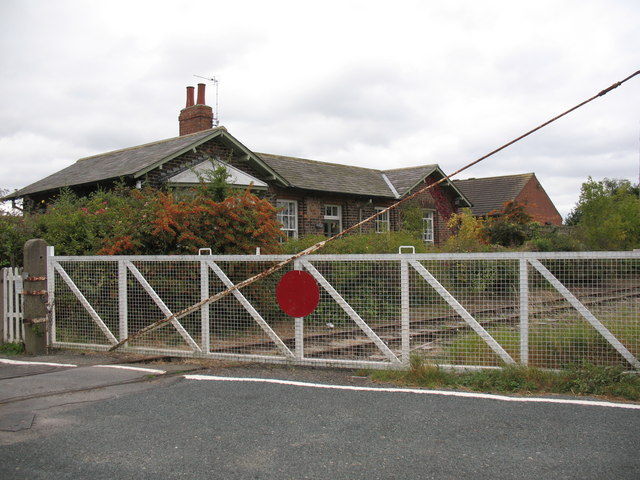
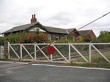
The old station at Morton-on-Swale

External links

Media related to Morton-on-Swale at Wikimedia Commons


Wikimedia Foundation. 2010.

Игры ⚽ Нужно решить контрольную?

Look at other dictionaries:

  • Morton — ist der Name folgender Orte: im Vereinigten Königreich: Morton (Derbyshire) Morton (Gloucestershire) Morton (Isle of Wight) Morton (Norfolk) Morton (Nottinghamshire) Morton and Hanthorpe in Lincolnshire Morton on Swale in North Yorkshire in den… …   Deutsch Wikipedia

  • Morton — See also: Moreton (disambiguation) Morton may refer to: Contents 1 People 2 Fictional 3 Places 4 Other uses People …   Wikipedia

  • River Swale — Infobox River river name = River Swale caption = The River Swale near Richmond. origin = Yorkshire Dales above Great Shunner Fell. mouth = Hull (River Humber) basin countries = England length = elevation = discharge = watershed = The River Swale… …   Wikipedia

  • Dales & District — A Dales District Optare Solo. Parent Procters Coaches …   Wikipedia

  • John Carr (architect) — John Carr (1723 1807) was a prolific English architect. He was born in Horbury, near Wakefield, England, the eldest of nine children and the son of a master mason, under whom he trained. [http://www.oxforddnb.com/view/article/4747 Oxford… …   Wikipedia

  • List of civil parishes in North Yorkshire — This is a list of civil parishes in the non metropolitan county of North Yorkshire, England, and the non metropolitan districts of Middlesbrough, Redcar and Cleveland, Stockton on Tees (south of the river) and York.CravenCraven is entirely… …   Wikipedia

  • Richmond (Yorks) (UK Parliament constituency) — UK constituency infobox Name = Richmond (Yorks) Map1 = Richmond Type = County Map2 = NorthYorkshire Entity = North Yorkshire County = North Yorkshire Year = 1585 MP = William Hague Party = Conservative EP = Yorkshire and the HumberRichmond… …   Wikipedia

  • Ainderby Steeple — infobox UK place country = England static static image caption = Spring flowers on the village green, Ainderby Steeple latitude = 54.3381 longitude = 1.42866 official name = Ainderby Steeple population = shire district= Hambleton shire county =… …   Wikipedia

  • Warlaby — infobox UK place country = England static static image caption = Warlaby latitude = 54.31771 longitude = 1.46451 official name = Warlaby population = shire district= Hambleton shire county = North Yorkshire region = Yorkshire and the Humber… …   Wikipedia

  • A684 road — UK road routebox road= A684 length mi= 70 length km= 112 direction= West East start= Kendal end= Ellerbeck (A19 road) construction date= completion date= junctions= ukroadsmall|6 ukmotorwaysmall|6 ukroadsmall|683 ukroadsmall|6108 ukroadsmall|1… …   Wikipedia

Share the article and excerpts

Direct link
Do a right-click on the link above
and select “Copy Link”