- Mono Basin
-
Mono Basin 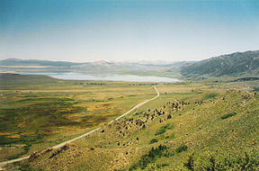
Mono Basin from near Conway Summit.Location Mono County, California, United States Floor elevation 6,380 feet (1,940 m) Area 631 to 801 square miles (1,630 to 2,070 km2) Depth 6,680 feet (2,040 m) Coordinates 38°0′0″N 119°0′0″W / 38°N 119°WCoordinates: 38°0′0″N 119°0′0″W / 38°N 119°W The Mono Basin is an endorheic drainage basin located east of Yosemite National Park in California and Nevada.[1][2] It is bordered to the west by the Sierra Nevada, to the east by the Cowtrack Mountains, to the north by the Bodie Hills, and to the south by the north ridge of the Long Valley Caldera.[3]
Estimates of the size of the basin range from 634 to 801 square miles, and the basin's elevation ranges from around 6,380 feet (level of Mono Lake as of 1986) to 13,061 feet atop Mount Dana near the Sierra Crest.[4][5][6]
Geologically the basin is a structural basin that is bordered to the west by the frontal fault of the Sierra Nevada. The basin has developed over the past three million years.[3]
Notable features in the basin include Mono Lake and the Mono-Inyo Craters, as well as the town of Lee Vining.
See also
References
- ^ Mono Basin Ecosystem Study Committee, National Research Council (1987). The Mono Basin ecosystem : effects of changing lake level. Washington, D.C.: National Academy Press. p. 1. ISBN 9780309037778. http://books.google.com/books?id=J_bYwMC_zr8C&pg=PA12&dq=%22mono+basin%22&hl=en&ei=gxBDTfe7LZSCsQPZsq30Cg&sa=X&oi=book_result&ct=result&resnum=3&ved=0CDYQ6AEwAg#v=onepage&q&f=false. Retrieved 28 January 2011.
- ^ Schweich, Tom. "Overview Map of Mono Basin". Eastern Mojave Vegetation. http://www.schweich.com/imagehtml/Mono_Basin_Overview.html. Retrieved 28 January 2011.
- ^ a b Mono Basin, Mono County, California
- ^ Mono Basin Ecosystem Study Committee, National Research Council (1987). The Mono Basin ecosystem : effects of changing lake level. Washington, D.C.: National Academy Press. p. 13. ISBN 9780309037778. http://books.google.com/books?id=J_bYwMC_zr8C&pg=PA12&dq=%22mono+basin%22&hl=en&ei=gxBDTfe7LZSCsQPZsq30Cg&sa=X&oi=book_result&ct=result&resnum=3&ved=0CDYQ6AEwAg#v=onepage&q&f=false. Retrieved 28 January 2011.
- ^ "Mono Basin EIR" (PDF). May 1993. p. 3A-6. http://www.monobasinresearch.org/images/mbeir/dchapter3/3a.pdf. Retrieved 28 January 2011.
- ^ "Mount Dana". NGS data sheet. U.S. National Geodetic Survey. http://www.ngs.noaa.gov/cgi-bin/ds_mark.prl?PidBox=HR2738.
External links
Categories:- Sierra Nevada (U.S.)
- Landforms of Mono County, California
- Valleys of California
- Sierra Nevada geography stubs

Wikimedia Foundation. 2010.