- Muntenia
-
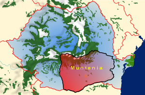
Muntenia (Romanian pronunciation: [munˈteni.a], also known in English as Greater Wallachia) is a historical province of Romania, usually considered Wallachia-proper (Muntenia, Țara Românească, and the seldom used Valahia are synonyms in Romanian). It is situated between the Danube (south and east), the Carpathian Mountains (the Transylvanian Alps branch) and Moldavia (both north), and the Olt River to the west.[1] The latter river is the border between Muntenia and Oltenia (or Lesser Wallachia). Part of the traditional border between Wallachia/Muntenia and Moldavia was formed by the rivers Milcov and Siret.
Geography
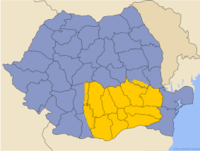
Muntenia includes ten counties entirely:
and parts of three others:
Romania's capital city, Bucharest, is situated in Muntenia. Other important cities are:
References
- ^ "The Muntenia Region". Rest Romania SRL. Retrieved 12 January 2010.
 Historical regions in RomaniaBanat (1918–)a • Dobruja (Northern Dobruja (1878–) • Southern Dobruja (1913–40) • Moldavia (1866–) (Bessarabia (1918–40; 1941–44)b • Bukovinac • Hertza (1866–1940; 1941–44)) • Transylvania (1918–)ad (Crişanae • Maramureş) • Wallachia (1866-) (Muntenia • Oltenia)
aDe jure since 1920. bCahul, Ismail and Bolgrad in Romania, 1866–78.
cSouthern Bukovina in Romania 1918–; Northern Bukovina, 1918–40. dNorthern Transylvania in Hungary, 1940–44. eOnly the eastern part.Categories:
Wikimedia Foundation. 2010.


