- Downtown Richmond, Virginia
-
Coordinates: 37°32′44″N 77°26′20″W / 37.54556°N 77.43889°W
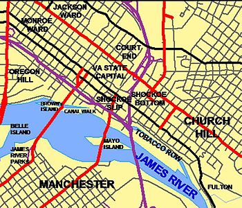 There are several areas in Downtown Richmond, including Shockoe Bottom, Shockoe Slip, the River District, Belle Isle, Monroe Ward, Manchester, Jackson Ward, Main Street, Court End, Tobacco Row, and the Canal Walk. edit
Downtown Richmond, Virginia, is central urban area of that city. It is generally defined as being bound by Belvidere Street to the west, I-95 to the north and east, and the James River to the south.
Description
The area contains many buildings and locations, including the James Monroe Building, VCU Medical Center, The American Civil War Center at Tredegar Iron Works, the Library of Virginia, Richmond Convention Center, the Colosseum, the Red Cross building, the Downtown YMCA, the Virginia State Capitol building, the Federal Reserve Bank of Richmond, the James Center Plaza, the Dominion building, New Market Corp. (formerly Ethyl) headquarters, Belle Isle park in the James River, and The Empire Theatre (the state's oldest operating theatre and home to Theatre IV, The Children's Theatre of VA).
Neighborhood districts within the downtown include Shockoe Slip, the River District, Monroe Ward, Jackson Ward, Main Street, Court End and the Canal Walk. In addition, though formally east of downtown proper, Shockoe Bottom and Tobacco Row are often considered downtown to many Richmond residents.
 Panoramic view from Richmond City Hall looking South along 9th Street. The Business district lies center frame. The Virginia State Capitol and Richmond's old city hall are visible in the center and lower left.
References
External links
The Greater Richmond Region Regional Divisions The West End · The Fan · Downtown · Southside · North Side · Mechanicsville · The East End · Tri-Cities / Petersburg · Varina-Enon
Surrounding Counties Chesterfield · Hanover · Henrico · Goochland
Other Counties Amelia · Caroline · Charles City · Cumberland · Dinwiddie · King and Queen · King William · Louisa · New Kent · Powhatan · Prince George · Sussex
Categories:- Richmond County, Virginia geography stubs
- Geography of Richmond, Virginia
- Central business districts in the United States

Wikimedia Foundation. 2010.