- Margerie Glacier
-
Margerie Glacier 
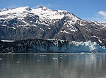
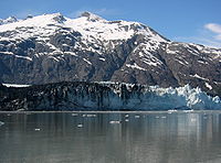
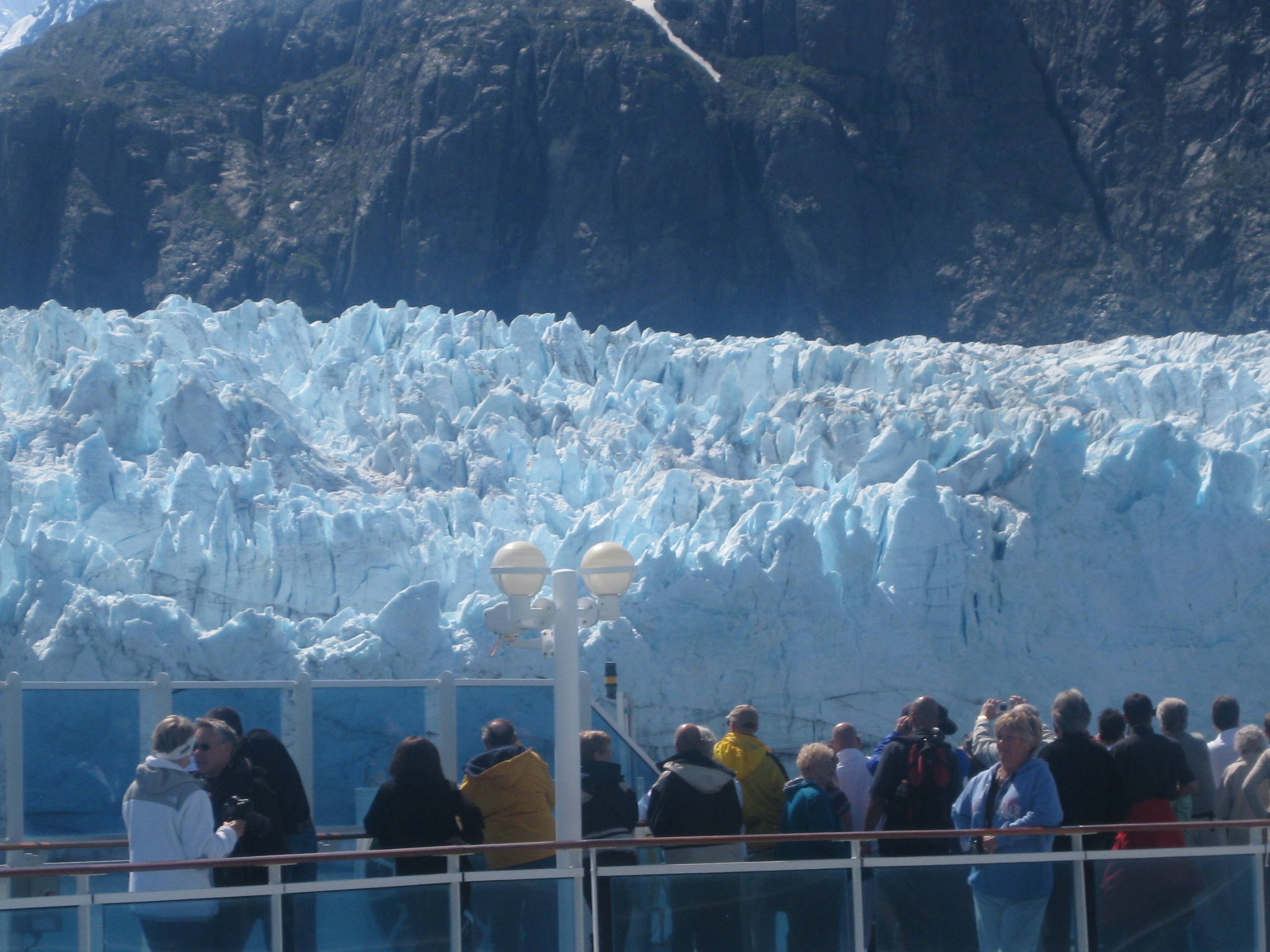
View of Margerie Glacier from a cruise ship in Glacier BayType Tidewater Glacier Location Descending from the Mount Root to Glacier Bay, Alaska. Coordinates Coordinates: 58°58′04″N 137°10′33″W / 58.96778°N 137.17583°W Length 21 miles (34 km) Terminus Sealevel Status Stable Margerie Glacier is a 21-mile-long (34 km) tide water glacier in Glacier Bay in Alaska and is part of the Glacier Bay National Park and Preserve. It begins on the south slope of Mount Root, at the Alaska-Canada border in the Fairweather Range, and flows southeast and northeast to Tarr Inlet. It was named for the famed French geographer and geologist Emmanuel de Margerie (1862–1953), who visited the Glacier Bay in 1913. It is an integral part of the Glacier Bay, which was declared a National Monument on February 26, 1925, a National Park and Wild Life Preserve on December 2, 1980, a UNESCO declared World Biosphere Reserve in 1986 and a World Heritage Site in 1992. While most of the tidewater and terrestrial glaciers in the Park are stated to be thinning and receding over the last several decades, Margerie Glacier is said to be stable and Johns Hopkins Glacier is stated to be advancing, on the eastern face of the Fairweather Range.[1][2][3][4][5][6]
Contents
Topography
Located at the deep end of the Glacier Bay, Margerie Glacier extends over a width of about 1 mile (1.6 km) and extends upstream for a length of 21 miles (34 km) till its source on the southern slopes of the hill of Mount Root, at the Alaska-Canada border. Mount Root (elevation 12,860 feet (3,920 m)), named Boundary Peak 165, is a mountain in Alaska and British Columbia, is part of the Fairweather Range (Mt. Fairweather is the tallest peak with elevation of15,325 feet (4,671 m)) of the Saint Elias Mountains. It is named after Elihu Root, who was among the diplomats involved in settling the Alaska boundary dispute between the United States and Canada. The Margerie Glacier starts from this range of mountains from Mount Root.[2][3][4][7]
Marjerie Glacier at Mile 63 is perpendicular to the Grand Pacific Glacier at Mile 64 (widest glacier in the Glacier bay with width of about 2 miles (3.2 km)). It flows in southeast and northeast direction to Tarr Inlet, one mile (1.6 km) north of the terminus of Grand Pacific Glacier and 87 miles (140 km) northwest of Hoonah. Glacier Bay provides excellent glacier experiences of both receding and advancing glaciers existing side by side. Tarr Inlet forms the northwestern part of the Glacier Bay named in 1912 for professor of geology Dr Ralph Tarr. The Glacier Bay region, which in 1750 was a mass of ice of a single glacier, has undergone a dynamic change and is now a 65-mile long fjord.[2][7][8]
Glacier Bay and the Marjorie Glacier are approachable only by air and water. The steep dropoff of the Margerie Glacier cliff facilitates large cruise ships to park close to the glacier from where one gets incredible views of the glacier.[2][9]
In a study of the bed rock geology and mineral resources of the Glacial Bay, out of 17 areas classified as containing mineral deposits, Marjerie Glacier has been identified as containing copper deposits.[10]
History
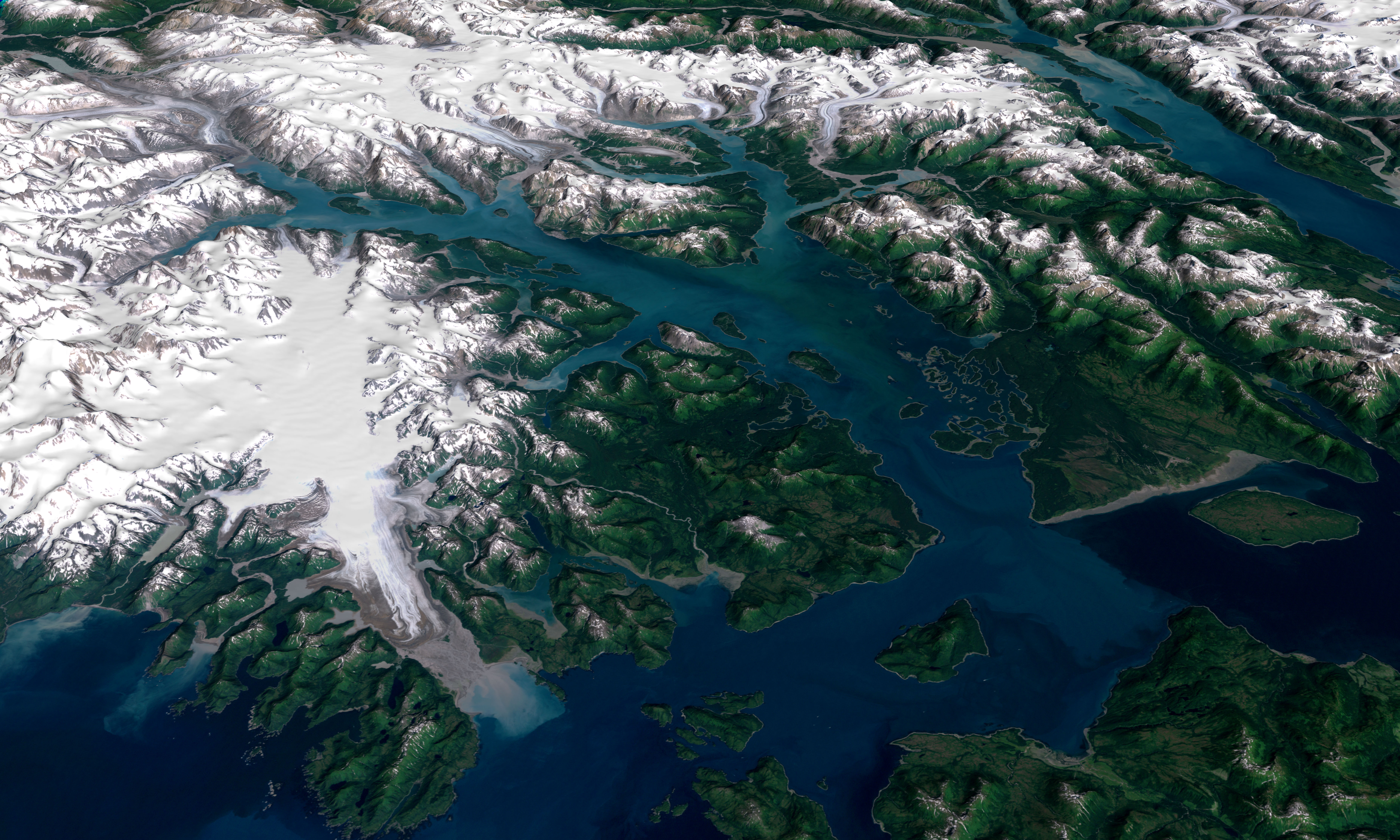
 Landsat imagery of Glacier explored by John Muir and others
History of the Marjerie Glacier is integral to the history of Glacier Bay. In 1791, Glacier Bay was a wall of ice when Captain Vancouver was blocked in his explorations by a wall of 2 miles (3.2 km) width and 4,000 feet (1,200 m) thick. 88 years later, when in 1888 John Muir had first visited the bay, this wall was 48 miles and had retreated by 44 miles (71 km). Now, it has retreated to 65 miles as a remnant of the old wall of the glacier system and has 16 major tidewater glaciers (10 and 12 were also mentioned in some references). Margerie Glacier is at Mile 63 of this system and named after French Geologist Emmanuel de Margerie who visited the area in 1913. The Great Pacific Glacier is at Mile 65 from the mouth of the Glacial Bay.[11]
Features

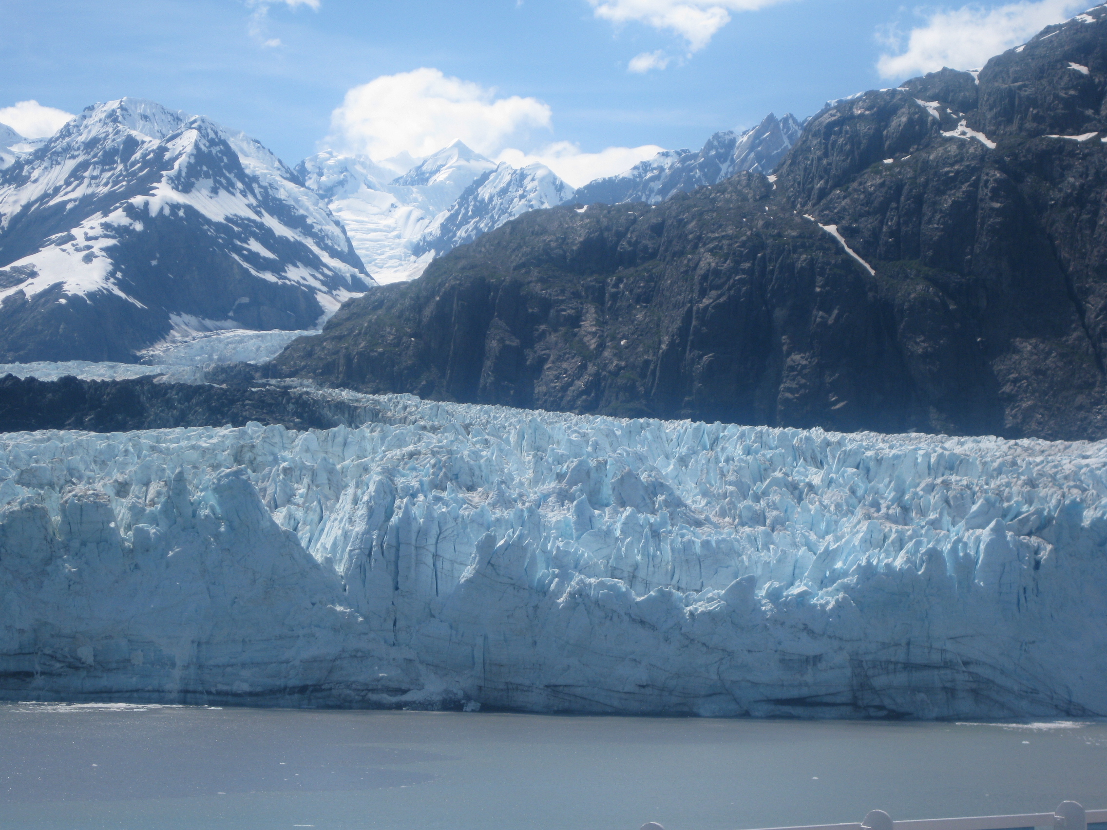
 Left: Full length (21 miles) of Marjerie Glacier from source to Bay. Right: Downstream view of Marjerie Glacier with layers of rock debris mixed with ice on the left end.
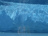
Margerie Glacier, categorized as a typical example of tide-water glacier (tidewater glacier is defined as a glacier which generates sufficient snow to flow out from the mountains to the sea.[12]), has a total height of 350 feet (110 m), out of which 250 feet (76 m) raises above the water level and 100 feet (30 m) is beneath the water surface. (This height is stated to be larger than the 307 feet (94 m) high Statue of Liberty). The glacier exhibits a distinctive curved layer of rock debris mixed with ice. The glacier has impressive configurations (as if carved with hand tools), in a "jagged and twisted form", set in ice which is seen in blue color as a result of absorption of rays of shorter red and green wavelengths. It is a much cleaner glacier as compared to other glaciers in the Glacier Bay. It is also one of the most active glacier for "Calving" (a word meaning breaking and dropping of ice walls into the sea).[1][13] As the glacier calves, "a rifle-like crack and a booming roar is heard creating a boiling like turbulence."[6]
Some times, ice caves get formed in the glacier, which is considered highly unstable since blocks of ice collapse into the water from the sides of the cave formation and create a resounding noise as it splashes.[1]
The glaciers in the Glacier Bay are stated to be remnants of a general "ice advance – the Little Ice Age – that began about 4,000 years ago". This advance is not comparable to continental glaciation that occurred during "Pleistocene times known as the Wisconsin Ice Age". However, about 1750, the 'Little Ice Age' reached its maximum stage and then melting started.[12] Ice flows have been recorded at Marjorie Glacier 2,000 feet (610 m) per year or 6 feet (1.8 m) per day. Its advance was reported to be at the rate of 30 feet (9.1 m) per year till 1998 when some degree of recession has been noticed at its northern terminus "forming a small embayment," while the southern part is advancing at 1 foot (0.30 m) per year. In the 1990s, the glacier was attached to the Grand Pacific Glacier. However, it is now detached from the Grand Pacific (which is said to be receding) and moranic material is seen where it has separated on its northern extremity, discerned by a small stream. As result, the Margerie Glacier is termed "a hanging glacier with its base about 600 feet (180 m) above the floor of Tarr Inlet near its center." Fresh water 'upswellings' are seen to emerge from the central area of the glacier, generated by the melt water discharges of sub glacial streams; such areas are swarmed by sea birds for feeding on fish.[6]
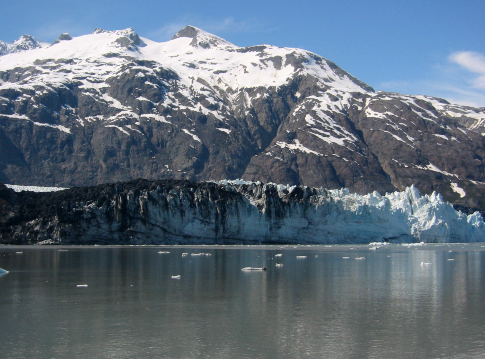
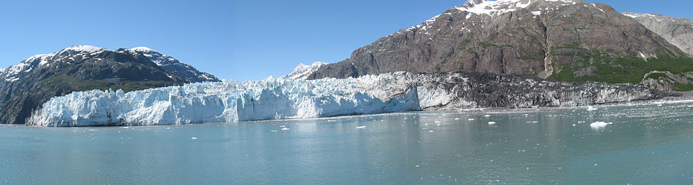 A panoramic view of Margerie Glacier, with adjacent Grand Pacific Glacier, 2006
Flora and fauna
Margerie Glacier is a part of the Glacier Bay National Park and Preserve, which is a myriad combination tidewater glaciers, snow-capped mountain ranges, ocean coastlines, deep fjords, and freshwater rivers and lakes, provides widely varying land and seascape “hosts a mosaic of plant communities and a variety of marine and terrestrial wildlife.”[7] Arctic terns and gulls nest in the rocks of the Margerie Glacier. As this glacier calves, it disturbs the krill and small fish, thus making it an ideal spot for birds. Whales and bears are also seen around this glacier.[6][9]
See also
- Glacier Bay
- Glacier Bay National Park and Preserve
- Fairweather Range
- Grand Pacific Glacier
- Mount Root
Gallery
-
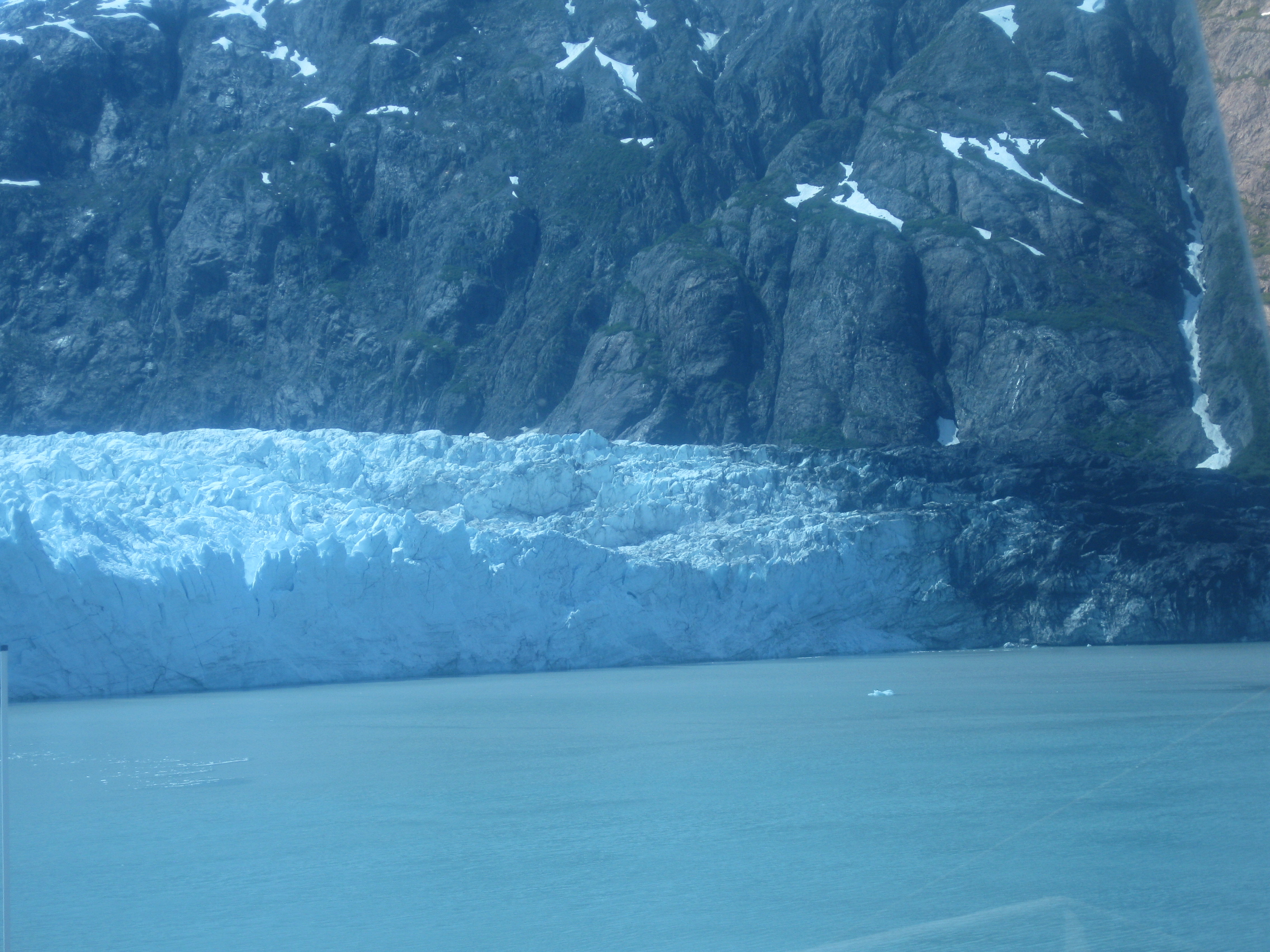
Close view of Margerie Glacier in Glacier Bay, Alaska
-

Another view of Margerie Glacier in Glacier Bay, Alaska
-

Margerie Glacier at end of the Glacier Bay in full view, Alaska
-
Margerie Glacier with the backdrop of Grand Pacific Glacier
References
- ^ a b c "Margerie Glacier". Glacier Bay National Park. http://www.lcss.net/glacierbay/Glacier_Bay_glaciers.htm. Retrieved 2010-07-22.
- ^ a b c d "Margerie Glacier, Glacier Bay National Park, Alaska". Glaciers on Waymarking.com. http://www.waymarking.com/waymarks/WM58Y8. Retrieved 2010-07-2010.
- ^ a b "Mount Fairwaether" (pdf). National Park Service. pp. 1, 4 & 11. http://www.nps.gov/glba/planyourvisit/upload/Climbing%20History.pdf. Retrieved 2010-07-22.
- ^ a b Breen, Terry. The Cruiser Friendly Onboard Guide to Alaska’s Inside Passage. pp. 123–127. http://books.google.com/books?id=Tb5E4GGDWTQC&pg=PA126&dq=Emmanuel+de+Margerie+and+Margerie+Glacier&hl=en&ei=ptpJTMrdK4_GsAP5j8VI&sa=X&oi=book_result&ct=result&resnum=2&ved=0CCwQ6AEwAQ#v=onepage&q=Emmanuel%20de%20Margerie%20and%20Margerie%20Glacier&f=false. Retrieved 2010-07-23.
- ^ "Glacier Bay National Park & Preserve, Alaska" (pdf). Glacier Bay National Park Service U.S. Department of the Interior. http://www.nps.gov/glba/upload/GLBA%20Fact%20Sheet%202010.pdf. Retrieved 2010-07-23.
- ^ a b c d Daniel E. Lawson. "An Overview of Selected Glaciers in Glacier Bay" (pdf). National park Service. pp. 1–4. http://www.nps.gov/glba/upload/2004%20Glaciers%20of%20Glacier%20Bay%20Overview.pdf. Retrieved 2010-07-23.
- ^ a b c "Glacier Bay". National Park Service: US Department of the Interior. http://www.nps.gov/glba/index.htm. Retrieved 2010-07-22.
- ^ "Grand Pacific and Margerie Glaciers". World Reviewer. http://www.worldreviewer.com/travel-guides/frozen-landscapes/grand-pacific-and-margerie-glaciers/14342/. Retrieved 2010-07-22.
- ^ a b Breen, p. 124.
- ^ "The Scientific Adventure: Proceedings of the First Glacier Bay Symposium" (pdf). Glacier Bay National Park and Preserve. 23-26. p. 22. http://www.nps.gov/glba/naturescience/upload/1983Symp.pdf. Retrieved 2010-07-23.
- ^ Breen, p. 122.
- ^ a b "Glacier Bay National Park and Preserve". National park Service. http://www.nps.gov/glba/naturescience/glaciers.htm. Retrieved 2010-07-23.
- ^ Cruise Travel Apr 1990. Lakeside Publishing Co.. 1990. ISSN 0199-5111 ISSN 0199-5111. http://books.google.com/books?id=CjEDAAAAMBAJ&pg=PA49&dq=Marjorie+Glacier&hl=en&ei=cLQ8TJ-rEIbEsAPgm7zaCg&sa=X&oi=book_result&ct=result&resnum=1&ved=0CCYQ6AEwAA#v=onepage&q=Marjorie%20Glacier&f=false. Retrieved 2010-07-23.
External links
- Margerie Glacier
- Mounfaitweather
- Glacier Bay Map. March 14, 2008. Accessed June 29, 2008 via site index National Park Service.
- Glacier Bay Map. March 14, 2008. Accessed June 29, 2008 via site index National Park Service.
Categories:- Glaciers of Alaska
- Landforms of Hoonah–Angoon Census Area, Alaska


Wikimedia Foundation. 2010.