California State Route 124
- California State Route 124
Infobox road
state=CA
type=SR
route=124
section=424
maint=Caltrans
length_mi=10.33
length_round=2
length_ref= [ [http://www.dot.ca.gov/hq/structur/strmaint/brlog2.htm January 1, 2006 California Log of Bridges on State Highways] ]
direction_a=South
terminus_a=jct|state=CA|SR|88 near Ione
direction_b=North
terminus_b=jct|state=CA|SR|16 near Drytown
previous_type=SR
previous_route=123
next_type=SR
next_route=125
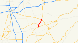
State Route 124 runs from Ione to Route 16 near Waits Station in Amador County.
This route is part of the California Freeway and Expressway System[ [http://www.leginfo.ca.gov/cgi-bin/displaycode?section=shc&group=00001-01000&file=250-257 CA Codes (shc:250-257)] ] .]Major intersections
:"Note: Except where prefixed with a letter, postmiles were measured in 1964, based on the alignment as it existed at that time, and do not necessarily reflect current mileage."
The entire route is in Amador County.
External links
* [http://www.dot.ca.gov/hq/roadinfo/sr124 Caltrans: Route 124 highway conditions]
* [http://www.cahighways.org/121-128.html#124 California Highways: Route 124]
References
Wikimedia Foundation.
2010.
Look at other dictionaries:
California State Route 16 — Infobox road state=CA type=SR route=16 section=316 maint=Caltrans length mi=111.17 length ref= [http://www.dot.ca.gov/hq/structur/strmaint/brlog2.htm July 2007 California Log of Bridges on State Highways] ] length round=2 length notes=(includes… … Wikipedia
California State Route 63 — State Route 63 Route information … Wikipedia
California State Route 41 — CA 41 redirects here. For the congressional district, see California s 41st congressional district. State Route 41 … Wikipedia
California State Route 139 — Infobox road state=CA type=SR route=139 section=439 maint=Caltrans length mi=121.836 length round=3 length ref= length notes=(plus about 21 mi (34 km) on SR 299) history=State highway in ca. 1940 and 1959; numbered by 1946 direction a=South… … Wikipedia
California State Route 125 — Infobox road state=CA type=SR route=125 section=425 maint=Caltrans length mi=36 length round=0 length ref= [ [http://www.dot.ca.gov/hq/structur/strmaint/brlog2.htm January 1, 2006 California Log of Bridges on State Highways] ] direction a=South… … Wikipedia
California State Route 123 — Infobox road state=CA type=SR route=123 section=423 maint=Caltrans length mi=7.39 length round=2 length ref= [ [http://www.dot.ca.gov/hq/structur/strmaint/brlog2.htm January 1, 2006 California Log of Bridges on State Highways] ] direction a=South … Wikipedia
California State Route 168 — Infobox road state=CA type=SR route=168 alternate name=Sierra Freeway, Tollhouse Road section=468 maint=Caltrans length mi=124 length round=2 length ref= [ [http://www.dot.ca.gov/hq/structur/strmaint/brlog2.htm January 1, 2006 California Log of… … Wikipedia
California Freeway and Expressway System — The California Freeway and Expressway System is a system of existing or planned freeways and expressways in the U.S. state of California. It is defined by the Streets and Highways Code.List of roads in the system*State Route 1 (part) *State Route … Wikipedia
List of highways numbered 124 — The following highways are numbered 124: Canada New Brunswick Route 124 Highway 124 (Ontario) United States Interstate 124 … Wikipedia
Liste der State-, U.S.- und Interstate-Highways in Kalifornien — Dies ist eine Aufstellung von State Highways in Kalifornien, USA nach Nummern. Inhaltsverzeichnis 1 State Routes 2 Interstates 2.1 Zubringer und Umgehungen 3 U.S. Highways … Deutsch Wikipedia
