cite web|url=https://metocph.nmci.navy.mil/jtwc/atcr/1959atcr/pdf/1959_complete.pdf|author=Joint Typhoon Warning Center|title=1959 Annual Typhoon Report|accessdate=2007-03-08|work=1959 Annual Tropical Cyclone Report] The first annual tropical cyclone report for the western North Pacific Ocean was issued by the agency.
Of the 23 tropical cyclones and 65 total areas of investigation, 17 storms attained typhoon status, which was below the yearly average of 19.
cite web|url=https://metocph.nmci.navy.mil/jtwc/atcr/1959atcr/pdf/1959_complete.pdf|author=Joint Typhoon Warning Center|title=1959 Annual Typhoon Report|accessdate=2007-03-08|work=1959 Annual Tropical Cyclone Report] At least nine other tropical systems never exceeded tropical storm intensity operationally. Most of the systems were noted to have developed within the typical spawning grounds for typhoons originating from easterly waves within the Intertropical Convergence Zone; the exceptions were Ellen and Georgia which developed from cold-core troughs extending southward into the tropical latitudes.
cite web|url=https://metocph.nmci.navy.mil/jtwc/atcr/1959atcr/pdf/1959_complete.pdf|author=Joint Typhoon Warning Center|title=1959 Annual Typhoon Report|accessdate=2007-03-08|work=1959 Annual Tropical Cyclone Report] Of the 17 typhoons that formed, five were first detected within 300 miles (500 km) of the island of Guam. Three of the typhoons developed at a slow rate, while three others rapidly intensified to typhoon status within hours. Only four typhoons were small in diameter, while at least three typhoons developed to large sizes and became the dominant tropical features during the season.cite web|url=https://metocph.nmci.navy.mil/jtwc/atcr/1959atcr/pdf/1959_complete.pdf|author=Joint Typhoon Warning Center|title=1959 Annual Typhoon Report|accessdate=2007-03-08|work=1959 Annual Tropical Cyclone Report] Two of the typhoons — Joan and Vera — featured sea-level pressures below 900 millibars and were the most intense tropical cyclones during the season, each featuring winds of 190 mph (305 km/h) or greater.cite web|url=https://metocph.nmci.navy.mil/jtwc/atcr/1959atcr/pdf/1959_complete.pdf|author=Joint Typhoon Warning Center|title=1959 Annual Typhoon Report|accessdate=2007-03-08|work=1959 Annual Tropical Cyclone Report] cite web|url=http://weather.unisys.com/hurricane/w_pacific/1959/index.html|author=Unisys|title=1959 Pacific typhoon season|accessdate=2007-04-04|work=1959 Hurricane/Tropical Data for Western Pacific] Of the total number of typhoons, 215 reconnaissance missions were flown into the storms, including 3,799 observations and 391 total fixes. The average track error for each advisory for storms during the season was 63.9 miles (102.8 km) for 12-hour forecasts and 301.6 miles (485.4 km) for 48-hour forecasts.cite web|url=https://metocph.nmci.navy.mil/jtwc/atcr/1959atcr/pdf/1959_complete.pdf|author=Joint Typhoon Warning Center|title=1959 Annual Typhoon Report|accessdate=2007-03-08|work=1959 Annual Tropical Cyclone Report]
Tropical Storm Ruby
Infobox Hurricane Small Basin=WPac
Formed=February 27 Dissipated=March 1 1-min winds=50 Pressure=998The first tropical storm of the season was detected by reconnaissance aircraft on February 27 about 300 miles (500 km) south of Yap with winds of 60 mph (90 km/h).cite web|url=http://weather.unisys.com/hurricane/w_pacific/1959/index.html|author=Unisys|title=1959 Pacific typhoon season|accessdate=2007-04-04|work=1959 Hurricane/Tropical Data for Western Pacific] Moving erratically westward, Ruby maintained intensity until it passed 90 miles (140 km) south of Palau on February 28, when it began to weaken and move to the west-northwest. Ruby weakened to below tropical storm intensity on March 1 and then turned to the southwest. The depression dissipated later on the same day 300 miles (500 km) east of Mindanao. Ruby was a short-lived tropical storm that did not affect any major land masses,cite web|url=http://weather.unisys.com/hurricane/w_pacific/1959/index.html|author=Unisys|title=1959 Pacific typhoon season|accessdate=2007-04-04|work=1959 Hurricane/Tropical Data for Western Pacific] and it was the only tropical cyclone in the season that formed during the month of February.
Tropical Storm Sally
Infobox Hurricane Small Basin=WPac
Formed=March 4 Dissipated=March 13 1-min winds=55 Pressure=990Three days after Ruby dissipated, the second tropical cyclone of the season was detected 200 miles (300 km) southeast of Majuro in the Marshall Islands with winds of 65 mph (100 km/h).cite web|url=http://weather.unisys.com/hurricane/w_pacific/1959/index.html|author=Unisys|title=1959 Pacific typhoon season|accessdate=2007-04-04|work=1959 Hurricane/Tropical Data for Western Pacific] After drifting northwest, Sally moved to the southwest on March 5 and then began to move westward, with its winds fluctuating to 50 mph (80 km/h). Sally soon restrengthened on March 6, reaching a secondary peak of 60 mph (90 km/h), and maintained its intensity for 18 hours as it moved steadily westward. After weakening to 45 mph (75 km/h) on March 8, Sally briefly jogged to the west-northwest on March 9, and it began to re-intensify as it turned back to the west, quickly reaching its third peak of 60 mph (90 km/h) on March 10.cite web|url=http://weather.unisys.com/hurricane/w_pacific/1959/index.html|author=Unisys|title=1959 Pacific typhoon season|accessdate=2007-04-04|work=1959 Hurricane/Tropical Data for Western Pacific] Sally slowly weakened as it turned to the northwest and slowed in forward speed, with its winds decreasing to 45 mph (75 km/h) on March 11. After briefly restrengthening to 60 mph (90 km/h) on March 12, Sally turned to the west and quickly weakened to a tropical depression. The depression briefly turned to the west-southwest and dissipated on March 13 300 miles (500 km) east of Mindanao.cite web|url=http://weather.unisys.com/hurricane/w_pacific/1959/index.html|author=Unisys|title=1959 Pacific typhoon season|accessdate=2007-04-04|work=1959 Hurricane/Tropical Data for Western Pacific]
Typhoon Tilda
Infobox Hurricane Small Basin=WPac
Formed=April 14 Dissipated=April 23 1-min winds=125 Pressure=964One month after Sally dissipated, the first typhoon of the season formed from a closed cyclonic circulation 300 miles (500 km) south of Chuuk. The circulation drifted westward, and reports from the surface showed intensification. On April 14 a reconnaissance aircraft mission estimated winds of tropical storm force, and the third tropical storm of the season was named Tilda.cite web|url=https://metocph.nmci.navy.mil/jtwc/atcr/1959atcr/pdf/wnp/04.pdf|author=Joint Typhoon Warning Center|title=Typhoon Tilda (Four)|accessdate=2007-04-17|work=1959 Annual Tropical Cyclone Report] Tilda slowly moved northwest at 9 mph (14 km/h) and briefly oscillated to 3 mph (6 km/h) on April 15 as it intensified to a typhoon with 75 mph (121 km/h) winds.cite web|url=http://weather.unisys.com/hurricane/w_pacific/1959/index.html|author=Unisys|title=1959 Pacific typhoon season|accessdate=2007-04-04|work=1959 Hurricane/Tropical Data for Western Pacific] Tilda then moved generally to the northwest with minor fluctuations on April 16 and the following day before turning northward on April 18, when it rapidly intensified. Tilda attained its peak intensity of 145 mph (230 km/h) 400 miles (600 km) west of Guam on April 19,cite web|url=https://metocph.nmci.navy.mil/jtwc/atcr/1959atcr/pdf/wnp/04.pdf|author=Joint Typhoon Warning Center|title=Typhoon Tilda (Four)|accessdate=2007-04-17|work=1959 Annual Tropical Cyclone Report] and it slowly weakened as it turned north-northeast and decreased in forward speed. The typhoon became quasi-stationary for 30 hours on April 20,cite web|url=https://metocph.nmci.navy.mil/jtwc/atcr/1959atcr/pdf/wnp/04.pdf|author=Joint Typhoon Warning Center|title=Typhoon Tilda (Four)|accessdate=2007-04-17|work=1959 Annual Tropical Cyclone Report] weakening to a minimal typhoon in the process by the next day. After drifting under weak steering currents, Tilda accelerated to the north-northeast on April 22 and weakened to a tropical storm. Tilda dissipated on April 23 as it merged with the upper-level westerlies130 miles (210 km) southwest of Iwo Jima.cite web|url=http://weather.unisys.com/hurricane/w_pacific/1959/index.html|author=Unisys|title=1959 Pacific typhoon season|accessdate=2007-04-04|work=1959 Hurricane/Tropical Data for Western Pacific] cite web|url=https://metocph.nmci.navy.mil/jtwc/atcr/1959atcr/pdf/wnp/04.pdf|author=Joint Typhoon Warning Center|title=Typhoon Tilda (Four)|accessdate=2007-04-17|work=1959 Annual Tropical Cyclone Report] Thirty-seven warnings for Tilda were issued by the Joint Typhoon Warning Center over the course of seven days. Tilda caused no damage or direct deaths.cite web|url=https://metocph.nmci.navy.mil/jtwc/atcr/1959atcr/pdf/wnp/04.pdf|author=Joint Typhoon Warning Center|title=Typhoon Tilda (Four)|accessdate=2007-04-17|work=1959 Annual Tropical Cyclone Report]
Infobox Hurricane Small Basin=WPac Formed=April 14 Dissipated=April 23 1-min winds=30 Pressure=UnknownAfter two months of inactivity, a tropical depression formed on July 4 in the South China Sea480 miles (770 km) west of Luzon. After briefly drifting northeast, the depression moved erratically northward on July 5, and it made landfall on mainland China east of Hong Kong on July 6. The depression quickly dissipated after moving inland.cite web|url=http://weather.unisys.com/hurricane/w_pacific/1959/index.html|author=Unisys|title=1959 Pacific typhoon season|accessdate=2007-04-04|work=1959 Hurricane/Tropical Data for Western Pacific] Operationally the system was classified as a tropical storm under the name Wilda, but post-analysis determined the tropical cyclone never attained winds of 39 mph (60 km/h) or greater. No reconnaissance aircraft investigated the system, which was one of only three disturbances not monitored during the season.cite web|url=https://metocph.nmci.navy.mil/jtwc/atcr/1959atcr/pdf/1959_complete.pdf|author=Joint Typhoon Warning Center|title=1959 Annual Typhoon Report|accessdate=2007-03-08|work=1959 Annual Tropical Cyclone Report]
Infobox Hurricane Small Basin=WPac Formed=July 12 Dissipated=July 18 1-min winds=90 Pressure=968An area of disturbed weather east of the Philippines organized into a tropical depression on July 12. Moving to the northwest, it quickly strengthened, reaching tropical storm status later on the 12th and typhoon strength on the 13th. After peaking at 105 mph (169 km/h), Billie crossed over northeastern Taiwan, quickly weakened, and made landfall on eastern China on the 15th. A trough of low pressure brought the storm northeastward, where after weakening to a tropical storm, it traversed the Yellow Sea and crossed the Korean Peninsula, losing tropical characteristics on the 18th. Typhoon Billie caused extreme flooding in northeastern Taiwan, causing $500,000 in property damage, leaving 10,000 homeless in the capital city of Taipei, and killing 1. In Japan, the outer edges of the typhoon caused torrential rains, killing 45 and destroying more than 65,000 houses.
Infobox Hurricane Small Basin=WPac Formed=August 2 Dissipated=August 12 1-min winds=100 Pressure=964115 mph (185 km/h) Typhoon Ellen, which reached its peak while south of Japan on August 4, struck the southern part of the country on the 7th. It paralleled the southern portion of the archipelago, and became extratropical on the 9th over the open western Pacific Ocean. Ellen dropped up to convert|35|in|mm of rainfall on Japan, killing 11 and causing severe rice crop damage. Ellen's greatest effect, however, was on Taiwan, where torrential rains associated with the typhoon caused disastrous flooding that killed nearly 700, left tens of thousands homeless, and destroyed much of the transportation infrastructure in the central and southwestern part of the island. Some locations received almost 50 inches of rain in three days, exceeding local annual average totals. The heaviest rain event was on August 7th, when as much as convert|25|in|mm of rain fell in the mountains and western plains, causing rivers and streams to burst through levees and flood thousands of hectares of farmland, washing away rural villages, and causing widespread urban flooding as well in Taichung and other cities. The economic impact was particularly extensive and long-lasting due to the widespread flooding of farmland. In Taiwan the event is remembered as the "Great August 7 (8-7) Flood".
Infobox Hurricane Small Basin=WPac Formed=August 12 Dissipated=August 15 1-min winds=110 Pressure=953Just 4 days after Ellen hit Japan, 105 mph (169 km/h) Typhoon Georgia hit the southeastern portion of the country. After rapidly crossing the archipelago it dissipated in the Sea of Japan on August 15. Georgia brought more heavy rains to the country, causing 246 fatalities and leaving over 50,000 homeless. Georgia caused torrential damage to Japan's railroad network, and, combined with Typhoon Ellen, produced a damage total of $50 million (1959 USD).
Infobox Hurricane Small Basin=WPac Formed=August 19 Dissipated=August 23 1-min winds=90 Pressure=966Typhoon Iris, which formed on August 19 to the east of Luzon, passed near the northeastern portion of the island on the 21st as a minimal typhoon. It turned to the northwest, peaking at 105 mph (169 km/h) before weakening to a tropical storm. Iris made landfall on southeastern China on the 22nd, and quickly dissipated. Typhoon Iris caused rough seas off the coast of Luzon, sinking at least two ships and killing 89 people. In China, the storm brought torrential rains, killing 720 people with 996 missing in the Fujian province in southeast China.
uper Typhoon Joan
Infobox Hurricane Small Basin=WPac Formed=August 25 Dissipated=August 31 1-min winds=170 Pressure=891On August 25, Tropical Storm Joan formed in the open Western Pacific, and attained typhoon status early the next day. As Joan moved to the west-northwest, it continued to rapidly intensify, reaching Super Typhoon status on the 28th and peak winds of 195 mph (314 km/h) on the 29th. Such winds are dubious, due to the infancy of Reconnaissance Aircraft at the time and the lack of satellite images. Nevertheless, Joan was a powerful typhoon, and struck eastern Taiwan with estimated winds of 185 mph (298 km/h) on the 29th. It rapidly weakened while crossing the island and the Formosa Strait, and dissipated over China on the 31st. Strong winds and heavy flooding caused 11 casualties and $3 million in crop damage. Property damage was extensive as well, with 3,308 houses destroyed from the typhoon. In China, 3 people were killed and 57 were injured from Joan.
infobox hurricane small name=Typhoon Louise category=cat4 type=hurricane
formed=August 30 dissipated=September 7, 1959 highest winds=120 knots (220 km/h, 140 mph) (1-min) lowest pressure=964 mbar (HPa)Just 5 days after Joan hit Taiwan, 135 mph (217 km/h) Typhoon Louise southeastern Taiwan, and quickly weakened as it moved northward. After weakening to a tropical depression over China, it restrengthened to a tropical storm before hitting North Korea and dissipating on September 7. Louise left 6 dead and over 6000 homeless.
Tropical Depression Marge
infobox hurricane small name=Tropical Depression Marge category=depression type=tropical depression
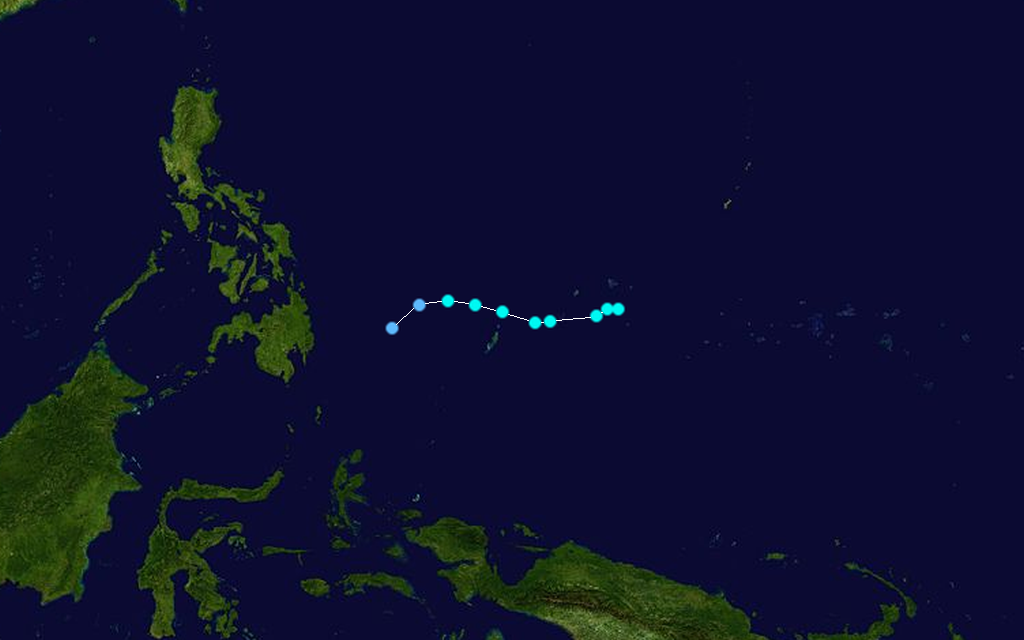
infobox hurricane small name=Typhoon Patsy category=cat4 type=hurricane
track=Patsy 1959 track.pngformed=September 6 dissipated=September 10, 1959 highest winds=150 knots (280 km/h, 175 mph) (1-min) lowest pressure=960 mbar (HPa)Hurricane Patsy reached a peak of 170 mph (270 km/h) winds while moving northward near the International Date Line. It remained out to sea, and dissipated on September 10.
Tropical Depression Ruth
infobox hurricane small name=Tropical Depression Ruth category=depression type=tropical depression
infobox hurricane small name=Super Typhoon Sarah category=cat5 type=hurricane
formed=September 11 dissipated=September 19, 1959 highest winds=165 knots (305 km/h, 190 mph) (1-min) lowest pressure=905 mbar (HPa)Super Typhoon Sarah, which peaked at 190 mph (310 km/h) on September 15, weakened to a 115 mph (185 km/h) typhoon just before making landfall on southern South Korea on the 17th. It continued to the northeast, and dissipated on the 19th over northern Japan. In the Ryūkyū Islands, Sarah's high winds and rain caused 6 deaths and destroyed 6,000 houses, causing $2 million in crop damage. In all of Korea, extreme flooding and storm surge killed 669 people and left 782,126 homeless. Extreme crop damage and property damage amounted to $100 million (1959 USD) ($638 million 2005 USD). Flooding in Japan killed 24, with thousands of houses either destroyed or damaged.
Tropical Depression Thelma
infobox hurricane small name=Tropical Depression Thelma category=depression type=tropical depression
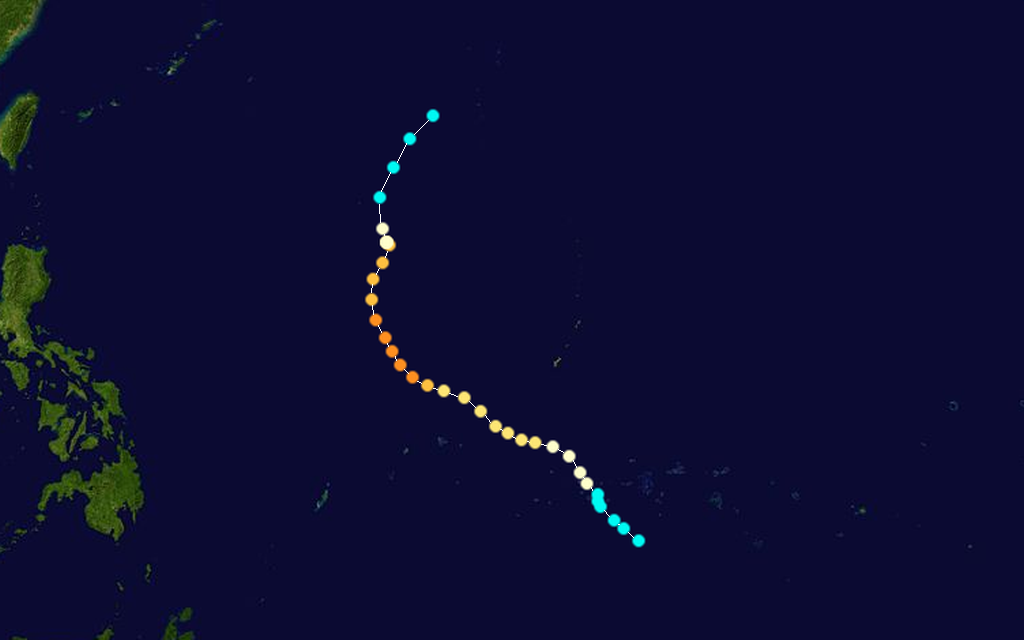
infobox hurricane small name=Super Typhoon Vera category=cat5 type=hurricane
track=Vera 1959 track.pngformed=September 21 dissipated=September 28, 1959 highest winds=165 knots (305 km/h, 190 mph) (1-min) lowest pressure=896 mbar (HPa)Typhoon Vera was one of Japan's worst typhoons ever, causing the deaths of 5,159 people and producing a damage total of $261 million dollars (1959 dollars).
Typhoon Amy
infobox hurricane small name=Typhoon Amy category=cat1 type=hurricane
infobox hurricane small name=Super Typhoon Charlotte category=cat5 type=hurricane
formed=October 9 dissipated=October 19, 1959 highest winds=145 knots (270 km/h, 165 mph) (1-min) lowest pressure=905 mbar (HPa)An area of low pressure organized into a tropical depression on October 9 to the east of the Philippines. It moved northwestward, quickly intensifying to typhoon status on the 10th. Charlotte continued to intensify, and reached a peak of 165 mph (266 km/h) on the 13th before recurving to the northeast. Cooler, drier air weakened the typhoon, and after passing near Okinawa on the 16th it paralleled the southern coast of Japan offshore. The weakening storm turned to the east, and dissipated on the 19th. Charlotte brought a total of convert|24|in|mm of rain on Okinawa, causing landslides that damaged much of the island. Crop damage was severe, with 75% of the rice crop destroyed. The five feet of flooding in some areas damaged 618 homes and destroyed 275. In all, Charlotte caused 46 casualties and left 1,068 homeless.
uper Typhoon Dinah
infobox hurricane small name=Super Typhoon Dinah category=cat5 type=hurricane
formed=October 14 dissipated=October 25, 1959 highest winds=150 knots (280 km/h, 175 mph) (1-min) lowest pressure=913 mbar (HPa)Just weeks after Super Typhoon Vera, another northward moving 170 mph (270 km/h) Super Typhoon was moving northward through the Pacific Ocean. Dinah's turn to the northeast spared the country, and it became extratropical on October 21 to the east of the archipelago.
Typhoon Emma
infobox hurricane small name=Typhoon Emma category=cat3 type=hurricane
infobox hurricane small name=Typhoon Freda category=cat4 type=hurricane
formed=November 13 dissipated=November 21, 1959 highest winds=115 knots (215 km/h, 135 mph) (1-min) lowest pressure=936 mbar (HPa)A disturbance in the Intertropical Convergence Zone organized into a tropical storm to the east of the Philippines on November 13. Freda moved west-northwestward, attaining typhoon status the next day. As it paralleled the northeast coast of Luzon, it rapidly intensified to a 135 mph (217 km/h) typhoon, and made landfall on the 16th with slightly weaker winds of 120, the weakening due to land interaction. Freda rapidly weakened as it crossed the island, and turned to the north. After passing close to Taiwan on the 18th, it accelerated to the north and became extratropical on the 20th. Freda brought torrential rains to the city of Manila, driving two vessels aground. Crop damage was heavy on the southern part of the island, while 7,600 were left homeless from the flooding. Freda caused 58 fatalities as it passed through the Philippines.
uper Typhoon Gilda
infobox hurricane small name=Super Typhoon Gilda category=cat5 type=hurricane
formed=December 13 dissipated=December 22, 1959 highest winds=150 knots (280 km/h, 175 mph) (1-min) lowest pressure=914 mbar (HPa)On December 18, 170 mph (270 km/h) Super Typhoon Gilda made landfall on the eastern Philippines. It quickly crossed the archipelago, and weakened over the South China Sea. Gilda made landfall on southeastern Vietnam on the 21st as a tropical storm, and dissipated the next day. Gilda caused 23 casualties in the Philippines from extensive rainfall, and left nearly 60,000 homeless.
uper Typhoon Harriet
infobox hurricane small name=Super Typhoon Harriet category=cat4 type=hurricane
formed=December 24, 1959 dissipated=January 2, 1960 highest winds=130 knots (240 km/h, 150 mph) (1-min) lowest pressure=926 mbar (HPa)On December 30, just weeks after Gilda, 145 mph (233 km/h) Typhoon Harriet hit the eastern Philippines. It weakened as it crossed the islands, and dissipated over the South China Sea on January 2. Harriet brought strong winds and rainfall to Luzon, causing considerable property and crop damage. In all, the typhoon killed 5 and left more than 12,000 homeless.
1959 storm names
Two Central Pacific storms developed and were named Dot and Wanda. The policy at the time was to use the Western Pacific nomenclature for the basin.
ee also
* 1959 Atlantic hurricane season * 1950-1969 Pacific hurricane seasons
References
External links
* [https://metocph.nmci.navy.mil/jtwc/atcr/1959atcr/pdf/1959.html Joint Typhoon Warning Center 1959 report] * [http://www.basedn.freeserve.co.uk/weather.htm Death stats]
1950-1959 Pacific typhoon seasons — The decade of the 1950s featured the 1950 1959 Pacific typhoon seasons. The seasons had no official bounds, but most tropical cyclones tend to form in the northwestern Pacific Ocean between June and December. These dates conventionally delimit… … Wikipedia
1960 Pacific typhoon season — Infobox hurricane season Basin=WPac Year=1960 Track=1960 Pacific typhoon season summary.jpg First storm formed=April 22, 1960 Last storm dissipated=December 20, 1960 Strongest storm name=Super Typhoon Shirley Strongest storm pressure=910 Total… … Wikipedia
1961 Pacific typhoon season — Infobox hurricane season Basin=WPac Year=1961 Track=1961 Pacific typhoon season summary.jpg First storm formed=January 14, 1961 Last storm dissipated=December 13, 1961 Strongest storm name=Super Typhoon Nancy, Super Typhoon Violet Strongest storm … Wikipedia
1958 Pacific typhoon season — Infobox hurricane season Basin=WPac Year=1958 Track=1958 Pacific typhoon season summary.jpg First storm formed=January 7, 1958 Last storm dissipated=December 8, 1958 Strongest storm name=Super Typhoon Ida Strongest storm pressure=877 Total storms … Wikipedia
1964 Pacific typhoon season — Infobox hurricane season Basin=WPac Year=1964 Track=1964 Pacific typhoon season summary.jpg First storm formed=May 14, 1964 Last storm dissipated=December 16, 1964 Strongest storm name=Sally Strongest storm pressure=894 Strongest storm winds=170… … Wikipedia
1957 Pacific typhoon season — Infobox hurricane season Basin=WPac Year=1957 Track=1957 Pacific typhoon season summary.jpg First storm formed=January 3, 1957 Last storm dissipated=November 25, 1957 Strongest storm name=Super Typhoon Lola Strongest storm pressure=900 Total… … Wikipedia
1981 Pacific typhoon season — Infobox hurricane season Track=1981 Pacific typhoon season summary.jpg Basin=WPac Year=1981 First storm formed=March 11, 1981 Last storm dissipated=December 28, 1981 Strongest storm name=Elsie Strongest storm pressure=893 Strongest storm… … Wikipedia
1976 Pacific hurricane season — Infobox hurricane season Basin=EPac Year=1976 Track=1976 Pacific hurricane season map.png First storm formed=June 2, 1976 Last storm dissipated=October 29, 1976 Strongest storm name=Annette Strongest storm pressure=925 Strongest storm winds=120… … Wikipedia
1992 Pacific hurricane season — Infobox hurricane season Basin=EPac Year=1992 Track=1992 Pacific hurricane season map.png First storm formed=January 26, 1992 Last storm dissipated=November 22, 1992 Strongest storm name=Tina Strongest storm winds=130 Strongest storm pressure=932 … Wikipedia
1982 Pacific hurricane season — Infobox hurricane season Basin=EPac Year=1982 Track=1982 Pacific hurricane season map.png First storm formed=May 20, 1982 Last storm dissipated=November 25, 1982 Strongest storm name=Olivia Strongest storm pressure= Strongest storm winds=125… … Wikipedia