- Colwell Bay
-
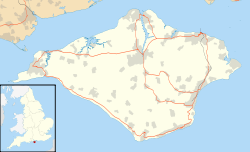
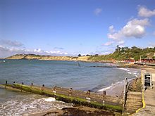
Colwell Bay (grid reference SZ323873) is a bay in the west of the Isle of Wight. It is located between the towns of Totland and Yarmouth. The bay's northernmost point is Cliff's End (Fort Albert) the closest point of the Island to the British mainland, with Hurst Castle lying at the end of a long peninsula just 1500 metres (a little less than a mile) to the northwest. The southernmost point is Warden Point.Colwell Bay has a popular beach, with two miles of sand and shingle, and facilities including cafes, shops and equipment hire outlets.
An area of 13.56 hectares has been notified as a geological Site of Special Scientific Interest, notification originally taking place in 1959. The site is significant for its Eocene geology and maritime vegetated soft cliff habitat.[1]
It is the location of three chines: Colwell Chine, Brambles Chine and Linstone Chine.
Colwell Bay is on the A3054 road and near the western end of the A3055 road. Public transport to the area is provided by Southern Vectis route 7 and the Needles Tour.
Colwell Bay Site of Special Scientific Interest Area of Search Isle of Wight Grid reference SZ323873 Interest Geological Area 13.56 hectare Notification 1959 Location map Natural England References
External links
- Colwell Bay, official IoW tourism website
- IOW Council information
Around the Bays of the Isle of Wight West
Totland BayColwell Bay East
Newtown BayChines on the Isle of Wight Alum Bay • Barnes Chine • Blackgang Chine • Brambles Chine • Brook Chine • Chilton Chine • Churchill Chine • Colwell Bay • Compton Chine • Cowleaze Chine • Grange/Marsh Chine • Ladder Chine • Linstone Chine • Luccombe Chine • New Chine • Shanklin Chine • Shepherd's Chine • Shippards Chine • Walpen Chine • Whale Chine • Widdick ChineSites of Special Scientific Interest on the Isle of Wight Alverstone Marshes • America Wood • Arreton Down • Bembridge Down • Bembridge School And Cliffs • Bonchurch Landslips • Bouldnor And Hamstead Cliffs • Brading Marshes To St. Helen's Ledges • Briddlesford Copses • Calbourne Down • Colwell Bay • Compton Chine to Steephill Cove • Compton Down • Cranmore • Cridmore Bog • Eaglehead and Bloodstone Copses • Freshwater Marshes • Garston's Down • Greatwood And Cliff Copses • Headon Warren And West High Down • King's Quay Shore • Lacey's Farm Quarry • Lake Allotments • Locks Farm Meadow • Medina Estuary • Mottistone Down • Newtown Harbour • Northpark Copse • Parkhurst Forest • Priory Woods • Prospect Quarry • Rew Down • Rowridge Valley • Ryde Sands and Wootton Creek • Shide Quarry • St Lawrence Bank • The Wilderness • Thorness Bay • Ventnor Downs • Whitecliff Bay And Bembridge Ledges • Yar Estuary
This article about a Site of Special Scientific Interest is a stub. You can help Wikipedia by expanding it. Categories:- Isle of Wight geography stubs
- United Kingdom Site of Special Scientific Interest stubs
- Sites of Special Scientific Interest on the Isle of Wight
- Geography of the Isle of Wight
- Bays of the Isle of Wight
- Beaches of the Isle of Wight
- Chines of the Isle of Wight
Wikimedia Foundation. 2010.
Look at other dictionaries:
Colwell — may refer to: Colwell Barton, Devon, England Colwell, Northumberland, England Colwell Bay, Isle of Wight, England Colwell, Iowa, United States This disambiguation page lists articles about distinct geographical locations with the same name. If an … Wikipedia
Newtown Bay — … Wikipedia
Eileen Colwell — (1904 – 2002) was a Pioneer Children’s Librarian.Born in Robin Hood’s Bay in Yorkshire, Colwell was the third daughter of a Methodist Minister. She obtained a scholarship and studied librarianship at University College. She had become interested… … Wikipedia
Headon-Hill-Formation — Die Headon Hill Formation ist eine geologische Formation im südengländischen Hampshire Becken. Sie ist die unterste Formation der Solent Gruppe und wurde im Oberen Eozän abgelagert. Nach ihr wurde das Headonium benannt, eine europäische… … Deutsch Wikipedia
Chine — For other uses, see Chine (disambiguation). Shanklin Chine, circa 1910 … Wikipedia
List of bays of the British Isles — This is a list of bays of the British Isles, geographically by island. They are listed by island, in clockwise order, from the stated starting point.BritainClockwise from the River Tweed:England from the River Tweed to the Bristol Channel*Budle… … Wikipedia
The Needles — For other uses, see The Needles (disambiguation). The Needles from the cliffs inshore at The Needles Battery … Wikipedia
Cranmore, Isle of Wight — Coordinates: 50°43′14″N 1°26′46″W / 50.72067°N 1.44623°W / 50.72067; 1.44623 … Wikipedia
Mottistone — For Lord Mottistone, the soldier and politician, see J. E. B. Seely, 1st Baron Mottistone. Mottistone is a village on the Isle of Wight, it is located in the popular tourist area the Back of the Wight.[1] It is located 8 Miles southwest of… … Wikipedia
Compton Down — Site of Special Scientific Interest Area of Search Isle of Wight Grid reference SZ365856 Interest Biological and Geological Area 196.3 hectare … Wikipedia


