North Wales (SEPTA station)
- North Wales (SEPTA station)
-
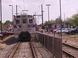
North Wales is a station along the SEPTA Lansdale/Doylestown Line. The station, located at Beaver and 5th Streets in North Wales, Pennsylvania, includes a 167-space parking lot.
External links
Categories: - SEPTA Regional Rail stations
- Stations along Reading Company lines
- Pennsylvania railway station stubs
- SEPTA stubs
Wikimedia Foundation.
2010.
Look at other dictionaries:
North Wales (disambiguation) — North Wales is an unofficial region of Wales, UK. North Wales may also refer to: North Wales, Pennsylvania, a suburb of Philadelphia in the United States North Wales (National Assembly for Wales electoral region), a constituency covering much of… … Wikipedia
North Wales, Pennsylvania — Coordinates: 40°12′39″N 75°16′30″W / 40.21083°N 75.275°W / 40.21083; 75.275 … Wikipedia
SEPTA Main Line — SEPTA Main Line A train operating on the SEPTA Main Line. Overview … Wikipedia
North Hills, Pennsylvania — North Hills is an unincorporated community in Abington, Springfield, and Upper Dublin townships in Montgomery County, Pennsylvania, United States. It is served by the 19038 zip code. It is a lesser developed town than their neighbor, Glenside. It … Wikipedia
Narberth, Pennsylvania — Coordinates: 40°00′27″N 75°15′44″W / 40.0075°N 75.26222°W / 40.0075; 75.26222 … Wikipedia
National Register of Historic Places listings in Montgomery County, Pennsylvania — Location of Montgomery County in Pennsylvania This is a list of the National Register of Historic Places listings in Montgomery County, Pennsylvania. This is intended to be a complete list of the properties and districts on National Register of… … Wikipedia
Upper Gwynedd Township, Pennsylvania — Geobox Township name = Upper Gwynedd Township native name = other name = other name1 = category = Township image size = image caption = Seal of the Township of Upper Gwynedd flag size = symbol = symbol size = nickname = motto = country = United… … Wikipedia
Pennsylvania Route 463 — PA Route 463 Route information M … Wikipedia
Cheltenham Township, Montgomery County, Pennsylvania — Coordinates: 40°04′00″N 75°06′59″W / 40.0666667°N 75.11639°W / 40.0666667; 75.11639 … Wikipedia
Oreland, Pennsylvania — Coordinates: 40°06′52″N 75°10′48″W / 40.11444°N 75.18°W / 40.11444; 75.18 … Wikipedia