- Moelwyn Mawr
-
Moelwyn Mawr 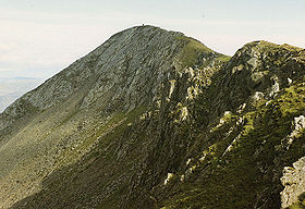
Moelwyn Mawr summit ridgeElevation 770 m (2,526 ft) Prominence 385 m (1,263 ft) Parent peak Moel Siabod Listing Marilyn, Hewitt, Nuttall Translation great white hill (Welsh) Pronunciation Welsh: [ˈmɔilwɨn ˈmaur] Location Location Gwynedd,  Wales
WalesRange Snowdonia Topo map OS Landranger 124 OS grid SH658448 Listed summits of Moelwyn Mawr Name Grid ref Height Status Moelwyn Bach 710 m (2,329 ft) Hewitt, Nuttall Craigysgafn 689 m (2,260 ft) sub Hewitt, Nuttall Moel-yr-hydd 648 m (2,126 ft) Hewitt, Nuttall Moelwyn Mawr North Ridge Top 640 m (2,100 ft) Nuttall Moelwyn Mawr is a mountain in Snowdonia, North Wales and forms part of the Moelwynion. From its summit, which directly overlooks the Vale of Ffestiniog, it affords spectacular views in all directions.
A popular hike combines both Moelwyn Mawr and Moelwyn Bach via the Craigysgafn ridge.
A steep climb to the summit (which sports a trig point) allow views of areas that cannot be seen without climbing.
Moelwyn Mawr has a high lake, Llyn Stwlan, which is used as part of the small hydro-electric power plant in Tanygrisiau.
The walk over the main peaks in the Moelwyns, those being Moelwyn Mawr and Moelwyn Bach involves a walk up a disused incline, before gaining the grassy slopes of Moelwyn Mawr and onto the rockier Moelwyn Bach, before walking back down the road from the Stwlan Dam. Both the Snowdonia and Harlech Ordnance Survey maps are needed to cover the walk. Transport to the beginning may be done by car to Tanygrisiau or Ffestiniog, or by train from Llandudno Junction.[1]
References
- ^ Nuttall, John & Anne (1999). The Mountains of England & Wales - Volume 1: Wales (2nd edition ed.). Milnthorpe, Cumbria: Cicerone. ISBN 1-85284-304-7.
External links
Coordinates: 52°59′01″N 4°00′02″W / 52.98369°N 4.00044°W

This article about a Site of Special Scientific Interest is a stub. You can help Wikipedia by expanding it.
