- Moel-yr-hydd
-
Moel-yr-hydd 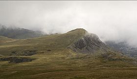
Moel-yr-hydd from Moelwyn MawrElevation 648 m (2,126 ft) Prominence 82 m (269 ft) Listing Hewitt, Nuttall Translation hill of the stag (Welsh) Pronunciation Welsh: [ˈmɔil ɐɾ ˈhɨːð] Location Location Gwynedd,  Wales
WalesRange Snowdonia Topo map OS Landranger 115 OS grid SH672454 Moel-yr-hydd is a subsidiary summit of Moelwyn Mawr in Snowdonia, North Wales and forms part of the Moelwynion. (Strictly the mountain is not actually in the Snowdonia National Park as it falls within the exclusion "hole" around the former slate town of Blaenau Ffestiniog.)
The mountain overlooks the village of Tanygrisiau and Tanygrisiau railway station (a halt on the Ffestiniog Railway) from where the mountain can easily be ascended.[1]
References
- ^ Nuttall, John & Anne (1999). The Mountains of England & Wales - Volume 1: Wales (2nd edition ed.). Milnthorpe, Cumbria: Cicerone. ISBN 1-85284-304-7.
External links
Coordinates: 52°59′22″N 3°58′47″W / 52.98943°N 3.97984°W
Categories:- Hewitts of Wales
- Mountains and hills of Snowdonia
- Nuttalls
- Gwynedd geography stubs

Wikimedia Foundation. 2010.