- Craigysgafn
-
Craigysgafn 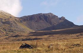
Elevation 689 m (2,260 ft) Listing sub Hewitt, Nuttall Translation mild crag (Welsh) Pronunciation Welsh: [ˈkræiɡ ˈɐsɡævn] Location Location Snowdonia, Wales Topo map OS Landranger 124 OS grid SH659443 Climbing Easiest route Walk, Scramble Craigysgafn is a rocky ridge and a top of Moelwyn Mawr that leads south from Moelwyn Mawr to Moelwyn Bach in Snowdonia, North Wales. It has several impressive gullies which lead directly down to the scree slopes above Llyn Stwlan. Some scrambling is needed in places.[1]
References
- ^ Nuttall, John & Anne (1999). The Mountains of England & Wales - Volume 1: Wales (2nd edition ed.). Milnthorpe, Cumbria: Cicerone. ISBN 1-85284-304-7.
External links
Coordinates: 52°58′45″N 3°59′55″W / 52.97922°N 3.99874°W
Categories:- Mountains and hills of Snowdonia
- Hewitts
- Nuttalls
- Ridges
- Gwynedd geography stubs

Wikimedia Foundation. 2010.