Churchill Falls Airport

Churchill Falls Airport
IATA: ZUMICAO: CZUM
WMO: 71182
Summary
Airport type Public
Owner/Operator Churchill Falls (Labrador) Corp.
Location Churchill Falls, Newfoundland and Labrador
Elevation AMSL 1,442 ft / 440 m
Coordinates 53°33′43″N 064°06′23″W / 53.56194°N 64.10639°W / 53.56194; -64.10639Coordinates: 53°33′43″N 064°06′23″W / 53.56194°N 64.10639°W / 53.56194; -64.10639
Map
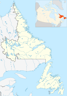
CZUM is located in Newfoundland and Labrador
CZUM
Runways
Direction Length Surface
ft m
13/31 5,500 1,676 Asphalt
Sources: Canada Flight Supplement[1]
Environment Canada[2]
Transport Canada[3]

Churchill Falls Airport (IATA: ZUMICAO: CZUM) is owned and operated by Churchill Falls Labrador Corporation Limited. Provincial Airlines provides regularly scheduled passenger service at the airport, which handled about 1,400 passengers annually over between 2000 and 2003. The airport is located 4 NM (7.4 km; 4.6 mi) northwest of Churchill Falls, Newfoundland and Labrador, Canada.

Four small structures are the only buildings, as the airport has no formal terminal.

References

  1. ^ Canada Flight Supplement. Effective 0901Z 20 October 2011 to 0901Z 15 December 2011
  2. ^ Synoptic/Metstat Station Information
  3. ^ Airport Divestiture Status Report

External links


Wikimedia Foundation. 2010.

Игры ⚽ Нужна курсовая?

Look at other dictionaries:

  • Aeropuerto de Churchill Falls — Churchill Falls Airport IATA: ZUM   OACI: CZUM Sumario Tipo Público …   Wikipedia Español

  • Deer Lake Airport (Newfoundland) — Infobox Airport name = Deer Lake Regional Airport image width = 150px IATA = YDF ICAO = CYDF type = Public owner = operator = Deer Lake Regional Airport Authority city served = location = Deer Lake, Newfoundland and Labrador elevation f = 72… …   Wikipedia

  • Deer Lake Regional Airport — For the airport in Ontario, see Deer Lake Airport. Deer Lake Regional Airport IATA …   Wikipedia

  • Wabush Airport — Infobox Airport name = Wabush Airport IATA = YWK ICAO = CYWK type = Public owner = operator = Transport Canada city served = location = Wabush, Newfoundland and Labrador elevation f = 1,808 elevation m = 551 coordinates =… …   Wikipedia

  • Ottawa Macdonald-Cartier International Airport — Ottawa Airport redirects here. For other airports in Ottawa, see List of airports in the Ottawa area. For the airport serving Ottawa County, Ohio, see Erie Ottawa Regional Airport. For the airport serving Ottawa, Kansas, see Ottawa Municipal… …   Wikipedia

  • Cincinnati/Northern Kentucky International Airport — Cincinnati Voir aussi une ville de quelques centaines d habitants : Cincinnati (Iowa). Cincinnati …   Wikipédia en Français

  • Hydro-Québec's electricity transmission system — is an expansive, international power transmission system located in Quebec, Canada with extensions into the Northeastern United States. Major expansion of the network began with the commissioning of the alternating current 735,000 volt (735 kV)… …   Wikipedia

  • Liste der IATA-Codes/Z — Diese Teilliste führt alle IATA Flughafen Codes auf, die mit „Z“ beginnen, und enthält Informationen zu den bezeichneten Verkehrsknotenpunkten. IATA Codes   A B C D E F G H …   Deutsch Wikipedia

  • CFB Goose Bay — Goose Bay Airport IATA …   Wikipedia

  • Diffusion of technology in Canada — This article outlines the history of the diffusion or spread of technology in Canada. Technologies chosen for treatment here include, in rough order, transportation, communication, energy, materials, industry, public works, public services… …   Wikipedia

Share the article and excerpts

Direct link
Do a right-click on the link above
and select “Copy Link”