- Church Stretton railway station
-
Church Stretton 
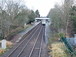
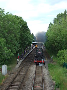
The station, looking north – a train for Carmarthen stands at platform 2 Location Place Church Stretton Local authority Shropshire Council Grid reference SO455935 Operations Station code CTT Managed by Arriva Trains Wales Number of platforms 2 Live arrivals/departures and station information
from National Rail EnquiriesAnnual rail passenger usage 2004/05 * 100,068 2005/06 *  104,206
2006/07 *  111,834
2007/08 *  125,955
2008/09 *  125,024
2009/10 *  117,812
History 1852 Opened 1914 Station moved National Rail - UK railway stations A B C D E F G H I J K L M N O P Q R S T U V W X Y Z * Annual passenger usage based on sales of tickets in stated financial year(s) which end or originate at Church Stretton from Office of Rail Regulation statistics. Please note: methodology may vary year on year. Church Stretton railway station is a railway station serving the town of Church Stretton in Shropshire, England. It is situated on the Welsh Marches Line, 12¾ miles (20.5 km) south of Shrewsbury railway station, while trains on the Heart of Wales Line also serve the station. All trains serving the station are operated by Arriva Trains Wales, who also manage the station.
Contents
History
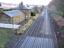
The station opened on 20 April 1852 as part of the newly created Shrewsbury and Hereford Railway along with the rest of the line and stations. It was originally situated to the north of (what is now known as) Sandford Avenue and the old station building still remains, but is no longer in railway use. Sandford Avenue had been for centuries called Lake Lane and became Station Road with the arrival of the railway in the town, before becoming Sandford Avenue in 1884.[1]
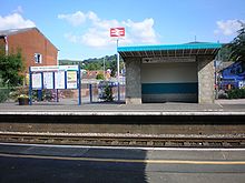
In 1914 the station was relocated just to the south of the Sandford Avenue road bridge, where it continues to the present day. New station buildings were erected, but these were demolished in 1970, the station having become unstaffed in 1967. Today the only station structures in use are two passenger shelters on the platforms and a footbridge.[1]
Today's station
The station has two platforms, one for northbound services (platform 1) and the other for southbound services (platform 2), with a footbridge crossing the line connecting the two platforms. The platform shelters were replaced and electronic information displays were installed in the spring of 2011. There are two small areas for car parking/dropping off, on either side of the line — one can be accessed from Sandford Avenue (the B4371), the other from Crossways (which comes off the A49).
The station lies on the highest point of the line between Shrewsbury and Craven Arms, and is the highest station in Shropshire. There is on the northbound platform a small plinth noting the station's altitude: 613ft (187m) above sea level.
As of May 2011, trains call (Monday to Saturday) approximately one per hour, running between Cardiff Central (and other locations in south Wales) and Manchester Piccadilly (via Crewe) or Holyhead (via Chester). All trains calling at Church Stretton also call at Shrewsbury, immediately prior or after, which is a 15 minutes' journey. Not all trains operating on the Welsh Marches Line stop at Church Stretton. Services operate infrequently on Sundays, with very few trains before mid-afternoon. There are four trains a day (two on Sundays) in each direction along the Heart of Wales Line, of which all call at Church Stretton.[2]
The station has a large number of passengers using it considering the town has a population of just 3000; it is the sixth most-used station in Shropshire (the fourth for the Shropshire Council area). The high usage can be explained by two reasons: the town is a popular tourist destination and many of its inhabitants travel to Shrewsbury and Ludlow for employment, education and shopping.
The station has been "adopted" by local volunteers and is regularly kept tidy by them, including the garden areas behind both platforms.[3] In 2011 a tree sculpture depicting two owls was carved by David Bytheway.[4]
Infrastructure
The track through the station is prone to flooding when heavy rain occurs as, although at the apex of the line, it is at the bottom of the valley which Church Stretton is found in. (Church Stretton effectively lies at a saddle point.) At one stage during the infamously wet autumn of 2000, the space between the two platforms resembled a canal and train services had to be cancelled along the line.
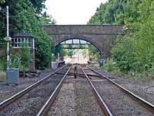
Following the serious flooding of the railway line in 2000, the signal box at Church Stretton (which was situated to the north of the Sandford Avenue bridge) was "switched out". The signal box at Church Stretton closed entirely in 2004 and the set of points at the station lay defunct for a number of years and were removed in 2009, together with the box (built 1872) and all signals.[1] The control of the line here has been transferred to Marsh Brook signal box, which is to the south.[5]
Bus connections
Church Stretton is served by the 435 bus route (the Shrewsbury-Ludlow service), run by Minsterley Motors, which runs Monday-Saturday.[6] This connects the town with some nearby villages including All Stretton, Dorrington, Leebotwood, Little Stretton and Marshbrook. In addition there is a Shropshire Hills Shuttles service (route 780) that operates during the spring/summer, which runs over the Long Mynd to Ratlinghope & Bridges, Stiperstones, Habberley and Pulverbatch. This operates at the weekends and on Bank Holiday Mondays.[7] Bus services run to and from Beaumont Road, 275 metres (301 yd) from the station (grid reference SO454937).
External links
- Train times and station information for Church Stretton railway station from National Rail
References
- ^ a b c Crowe and Raynor (2011) Church Stretton through the ages
- ^ Arriva Trains Wales — timetables
- ^ Church Stretton – Volunteering – Railway
- ^ Stretton Focus June 2011 page 11
- ^ The Signal Box 'Section C' – 2004
- ^ Minsterley Motors 435 timetable
- ^ Shropshire Hills AONB Shuttle bus service
Preceding station  National Rail
Following station Craven Arms Arriva Trains Wales
Welsh Marches LineShrewsbury Arriva Trains Wales
Cardiff-HolyheadArriva Trains Wales
Heart of Wales LineHistorical railways Little Stretton
Line open, station closedShrewsbury and Hereford Railway All Stretton
Line open, station closedCoordinates: 52°32′15″N 2°48′13″W / 52.5375°N 2.8035°W
National Rail stations Albrighton · Broome · Bucknell · Church Stretton · Cosford · Craven Arms · Gobowen · Hopton Heath · Knighton · Ludlow · Oakengates · Prees · Shifnal · Shrewsbury · Telford Central · Wellington · Wem · Whitchurch · Yorton
Severn Valley Railway stations Other heritage railway stations Llynclys South (Cambrian) · Horsehay & Dawley (Telford) · Spring Village (Telford)
Notable former stations Abbey Foregate · Baschurch · Market Drayton · Newport · Oswestry · Shrewsbury Abbey
Main article: Railways of Shropshire. Categories:- Railway stations in Shropshire
- Former Shrewsbury and Hereford Railway stations
- Railway stations opened in 1852
- Railway stations served by Arriva Trains Wales
- DfT Category F1 stations
Wikimedia Foundation. 2010.

